
The Rio Grande (known as the Río Bravo in Mexico) is one of North America’s most significant and historically influential rivers, stretching approximately 1,900 miles (3,060 kilometers) from the Rocky Mountains of Colorado to the Gulf of Mexico. For nearly 1,254 miles (2,018 kilometers) of its journey, the river serves as a natural boundary between the United States and Mexico, making it one of the world’s most prominent international rivers.
Rising in the high mountains of Colorado and flowing southward through deserts, mountains, valleys, and fertile plains before reaching the Gulf Coast, the Rio Grande connects rural communities, major metropolitan areas, and important border regions in a continuous natural system shaped by both geography and human activity.
It is not only a geographic landmark but also a lifeline for millions of people who depend on its waters for agriculture, drinking water supply, ecosystems, and economic development. The river’s importance goes far beyond its physical presence, as it has shaped settlement patterns, trade routes, and cultural identities across the American Southwest and northern Mexico.
Origin of the Rio Grande
The Rio Grande originates in the San Juan Mountains of the Rocky Mountains in southwestern Colorado. It springs to life as a high-altitude, snow-fed mountain stream in the western part of the Rio Grande National Forest, at an elevation of about 12,000 feet.
The river is formed by the convergence of several small, spring-fed streams at the base of Canby Mountain. It begins just east of the Continental Divide of the Americas.
At this early stage, the river flows through narrow valleys and steep terrain, where the water is fast-moving, cold, and highly oxygenated, supporting unique high-altitude ecosystems.
Course of the Rio Grande
The Rio Grande is a major transboundary river stretching roughly 1,900 miles from the high Rocky Mountains of southern Colorado to the Gulf of Mexico. Throughout its journey, it serves as a critical water source for communities, agriculture, and ecosystems across the southwestern United States and northern Mexico. It also forms 1,254 miles long natural boundary between the two countries, making it both a geographic feature and a political landmark.
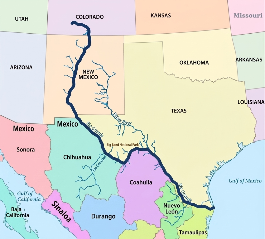
To understand its full journey, the river’s course is commonly divided into three major segments: the upper course, middle course, and lower course. Each section has distinct landscapes, climate conditions, and human uses that shape the river’s character.
Upper Course of the Rio Grande
In its upper course, the Rio Grande begins in the San Juan Mountains of the Rocky Mountains in southwestern Colorado. It originates within the Rio Grande National Forest as a high-altitude, snow-fed mountain stream. The river starts at an elevation of about 12,000 feet, where melting snow and spring-fed waters converge to form its early flow. This headwater region is located in San Juan County, Colorado, near approximately 37°47′ N latitude and 107°32′ W longitude, just east of the Continental Divide of the Americas.
At this early stage, the river is formed by the merging of several small streams at the base of Canby Mountain. The terrain is steep, cold, and heavily influenced by seasonal snowmelt, which controls the strength and volume of the river’s initial flow. As it moves southward into New Mexico, the Rio Grande begins to carve deep valleys and scenic canyons, including the famous Rio Grande Gorge near Taos. This upper section is characterized by dramatic elevation changes and fast-flowing water that gradually transitions into a broader river system.
Middle Course of the Rio Grande
The middle course of the Rio Grande begins as it flows through central New Mexico and continues toward the Texas border region. In this section, the river becomes more established and begins to play a major role in supporting agriculture, cities, and regional water systems. It passes through important urban centers such as Albuquerque and Las Cruces, where it provides essential water for municipal supply and irrigation.
As the river continues south, it approaches the region near El Paso, Texas, where it undergoes a significant geographic transition. Here, the Rio Grande turns southeast and begins forming the international boundary between the United States and Mexico. Along this stretch, it borders Mexican states including Chihuahua, Coahuila, Nuevo León, and Tamaulipas. The surrounding environment becomes increasingly arid, with desert landscapes, rugged terrain, and limited rainfall.
This middle course also includes dramatic natural features such as the canyon systems of Big Bend National Park, where the river winds through deep valleys and limestone cliffs. Despite the harsh environment, the river remains a vital water source. Its flow is strengthened by major tributaries such as the Pecos River in the United States and the Rio Conchos in Mexico, which help sustain water levels during seasonal fluctuations and dry periods.
Lower Course of the Rio Grande
In its lower course, the Rio Grande enters the Lower Rio Grande Valley, a region known for its warm climate and highly productive agricultural land. Here, the river slows significantly and spreads across flatter terrain, forming a wide and fertile corridor that supports intensive farming. This area is one of the most important agricultural zones in the region, relying heavily on the river for irrigation and water supply.
As the river approaches its final destination, it continues southeast until it reaches the Gulf of Mexico. The river eventually empties through a small delta system that has been greatly reduced over time due to water diversion and reduced natural flow. Even so, the lower course remains a critical ecological and economic zone, marking the final stage of the Rio Grande’s long journey from mountain headwaters to the sea.
Rio Grande Delta
The Rio Grande Delta represents the final stage of the Rio Grande, where the river eventually empties into the Gulf of Mexico after traveling nearly 1,900 miles from the Rocky Mountains of Colorado. This broad coastal region extends across southernmost Texas and northern Tamaulipas in Mexico, where the Rio Grande has formed a wide, lobate delta plain roughly 150 kilometers wide. More than just the river’s endpoint, the delta is a complex environmental and economic region that supports major cities, productive agricultural lands, and internationally important ecosystems.
The delta region has long been known for its fertile soils, extensive wetlands, and rich biodiversity. Over thousands of years, sediment carried downstream by the Rio Grande gradually accumulated near the river’s mouth, creating low-lying floodplains, marshes, and distributary channels. These natural processes formed a productive coastal environment that supported wildlife, fisheries, and agriculture. Historically, the delta was much larger and more active than it is today, with seasonal flooding helping maintain wetland ecosystems and replenish nutrient-rich soils.
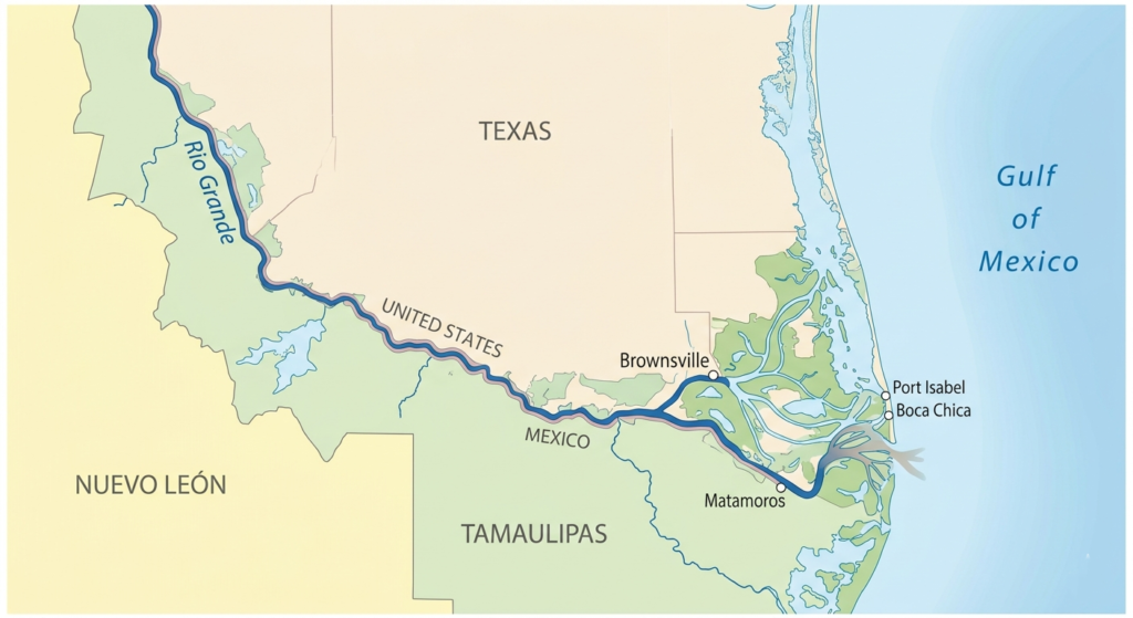
Geographically, the Rio Grande Delta is part of the broader Lower Rio Grande Valley, a warm sub-tropical region characterized by flat terrain, fertile farmland, and a relatively humid climate compared to the arid landscapes farther upstream. The river slows considerably in this lower section as it approaches the Gulf of Mexico, spreading across a wider floodplain before finally entering the sea through a narrow and sandy outlet.
One of the defining features of the delta region is its agricultural productivity. The combination of warm temperatures, fertile alluvial soils, and irrigation from the Rio Grande has transformed the Lower Rio Grande Valley into an important farming region. Crops such as citrus fruits, cotton, sugarcane, vegetables, and grains are widely cultivated throughout the area. Agriculture has become a major economic activity on both sides of the border, making the river’s water supply critically important for local communities and regional economies.
Beyond farming, the delta has also developed into a major bi-national economic hub. Metropolitan areas such as Brownsville and McAllen in Texas, along with Matamoros and Reynosa in Tamaulipas, play central roles in cross-border manufacturing, transportation, and international trade. The close economic connection between the United States and Mexico has transformed the region into an active industrial corridor where commerce, logistics, and population growth continue to expand rapidly.
One of the most distinctive ecological features of the delta is the Rio Grande Delta Thorn Woodland, a dense evergreen subtropical habitat found nowhere else in the United States. This thorny woodland ecosystem contains a mixture of drought-resistant shrubs, trees, and native vegetation adapted to the region’s warm climate and seasonal rainfall patterns. Although much of the original habitat has been cleared for agriculture and urban development, remaining patches continue to support diverse wildlife populations and rare plant species.
The delta also supports valuable ecosystems that provide habitat for numerous species of birds, fish, reptiles, and mammals. Because the region lies along major migratory bird routes, it serves as an important resting and feeding area for migratory species traveling between North and South America. Wetlands and riparian forests within the delta create ecological diversity that is relatively rare in the surrounding dry regions of the American Southwest and northern Mexico.
Despite its importance, the Rio Grande Delta has undergone significant environmental changes over the past century. Large-scale dam construction, irrigation projects, and water diversion upstream have drastically reduced the amount of freshwater reaching the delta. In many years, very little water from the Rio Grande actually reaches the Gulf of Mexico naturally. Reduced flow has caused wetland loss, increased salinity, habitat degradation, and shrinking coastal ecosystems that once depended on regular flooding and sediment deposits.
Urban development and agricultural expansion have also altered the natural landscape of the delta. Many original wetlands have been drained or converted into farmland and settlements, reducing biodiversity and disrupting natural ecological cycles. Climate change has added further pressure through rising temperatures, prolonged drought conditions, and the threat of sea-level rise along the Gulf Coast.
In response, conservation groups, environmental agencies, and regional planners on both sides of the border have worked to protect and restore portions of the delta ecosystem. Restoration projects focused on wetlands, thorn woodlands, and wildlife habitats aim to preserve the natural character of the region while balancing the growing demands of agriculture, cities, and industry.
Today, the Rio Grande Delta remains one of the most geographically unique and strategically important regions along the entire river system. It serves as a meeting point between river and ocean, nature and development, and the economies of two nations. Even though modern water management and urban expansion have transformed much of the original landscape, the delta continues to play a vital role in supporting biodiversity, agriculture, trade, and coastal life along the Gulf of Mexico.
Rio Grande Basin
The Rio Grande Basin is one of the largest and most geographically diverse river basins in North America. Covering more than 330,000 square miles (800,000 square kilometers), the basin stretches across the U.S. states of Colorado, New Mexico, and Texas, while also extending into the Mexican states of Chihuahua, Durango, Coahuila, Nuevo León, and Tamaulipas. The basin includes all the land areas drained by the Rio Grande and its tributaries, creating a vast watershed system that supports millions of people, major agricultural regions, industries, and ecosystems across two nations.
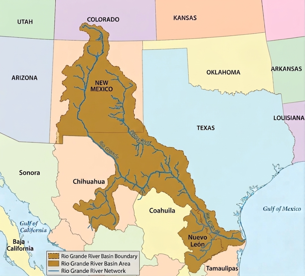
One of the defining characteristics of the Rio Grande Basin is its international significance. For approximately 1,254 miles of its journey, the Rio Grande forms the natural boundary between the United States and Mexico, making it one of the most important transboundary river systems in North America. Throughout this border region, the river serves as a critical source of drinking water, irrigation, industry, and ecological support for rapidly growing urban centers and rural communities alike.
In Texas alone, the Rio Grande Basin drains nearly 86,720 square miles of land. Because of the basin’s enormous size and the wide range of landscapes it covers, environmental conditions vary considerably from one region to another. Mountain headwaters, desert valleys, grasslands, reservoirs, wetlands, and coastal plains all form part of the broader watershed system. To better manage these differences, the basin is commonly divided into four major sections: the Upper Rio Grande Sub-Basin, the Middle Rio Grande Sub-Basin, the Lower Rio Grande Sub-Basin, and the Pecos River Basin.
Upper Rio Grande Basin
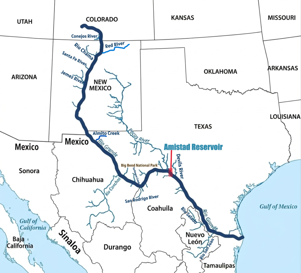
The Upper Rio Grande Basin begins at the Texas–New Mexico border and extends downstream to the International Amistad Reservoir. This section covers approximately 650 river miles and is characterized by semi-arid conditions, hot summers, limited rainfall, and long periods of intense sunshine. Water in this region is heavily used for agriculture and municipal supply, making irrigation and drinking water the dominant demands placed on the river system.
Because irrigation withdrawals are extensive in this section, water quality and water availability have become major concerns. Agricultural runoff, increasing salinity, and reduced river flow affect both environmental conditions and long-term water sustainability. Despite these challenges, the river remains essential to the communities and cities located within the basin.
This sub-basin includes major population centers such as El Paso, Texas, and Ciudad Juárez, Mexico, which together form one of the largest binational metropolitan regions along the border, with a combined population of several million residents. The region also includes communities such as Presidio and Ojinaga, as well as environmentally important areas like Big Bend National Park, where the river flows through dramatic desert canyons and rugged landscapes.
Middle Rio Grande Basin
The Middle Rio Grande Basin extends from the Amistad Reservoir downstream to Falcon Reservoir and covers approximately 303 river miles. This section of the basin continues through an arid environment where temperatures are frequently high and rainfall remains limited. Water from the river is widely used for agriculture, municipal supply, and industrial activities, making the basin economically important for both the United States and Mexico.
Urban development along this portion of the river has increased pressure on water resources and environmental quality. One of the most common concerns in the region is elevated bacteria levels in the water, which can affect public health and ecosystem conditions. Population growth and expanding infrastructure have made water management increasingly important throughout the basin.
Several major cross-border metropolitan areas are located within this sub-basin. The neighboring cities of Laredo, Texas, and Nuevo Laredo, Mexico, form a major commercial and transportation corridor, while Eagle Pass and Piedras Negras also serve as important border communities. Reservoir systems in this section, particularly Amistad and Falcon reservoirs, play essential roles in flood control, water storage, irrigation support, and hydroelectric power generation.
Lower Rio Grande Basin
The Lower Rio Grande Basin begins below Falcon Reservoir and continues downstream to the Gulf of Mexico, covering roughly 280 river miles. This region includes the Lower Rio Grande Valley, one of the most agriculturally productive areas along the U.S.-Mexico border. The climate ranges from arid to semi-arid, although it becomes warmer and slightly more humid closer to the Gulf Coast.
Communities throughout this sub-basin rely almost entirely on the Rio Grande for their water supply. Cities such as McAllen, Harlingen, and Brownsville in Texas depend heavily on the river for drinking water, irrigation, and economic activity. On the Mexican side, Reynosa and Matamoros are major urban centers with rapidly growing populations that also depend on the river system.
Agriculture remains one of the dominant industries in the lower basin, supported by fertile soils and extensive irrigation systems. However, this section faces several environmental challenges, including elevated salinity levels, bacterial contamination, and low dissolved oxygen in certain areas. Reduced freshwater flow and heavy water demand have intensified these issues over time, placing stress on ecosystems and water quality throughout the lower basin.
Pecos River Basin
The Pecos River is one of the most important tributaries within the Rio Grande Basin. Originating in the Sangre de Cristo Mountains of New Mexico, the river flows approximately 926 miles through New Mexico and Texas before joining the Rio Grande near the Amistad International Reservoir. Its waters contribute significantly to the overall flow of the Rio Grande system, particularly in the western Texas region.
Like much of the surrounding basin, the Pecos River region experiences predominantly arid to semi-arid climate conditions. Water from the Pecos is heavily utilized for irrigation and municipal purposes, especially in farming communities that depend on reliable access to freshwater. However, intensive water use and natural climatic conditions have contributed to environmental concerns such as high salinity and low dissolved oxygen levels.
Several communities and regional centers, including Pecos, Fort Stockton, and Monahans, are located within the Pecos River Basin. These towns rely on the river system for agriculture, economic activity, and local water supplies. Although the Pecos River flows through relatively dry and sparsely populated terrain, it remains a critical component of the larger Rio Grande watershed system.
Tributaries of the Rio Grande
The Rio Grande is sustained by an extensive network of tributaries that flow into the river from both the United States and Mexico. These tributaries play a critical role in maintaining water levels, supporting agriculture, replenishing ecosystems, and sustaining communities across the arid and semi-arid landscapes of the Rio Grande Basin. Because much of the basin experiences limited rainfall and high evaporation rates, tributary rivers and seasonal streams are essential for preserving the overall health and functionality of the river system.
Throughout its course, the Rio Grande receives water from mountain streams, spring-fed rivers, desert creeks, and major regional waterways. Some tributaries contribute consistent year-round flow, while others are highly seasonal and depend heavily on rainfall and monsoon activity. Together, they form a complex watershed network that supports both environmental systems and binational water supplies across the southwestern United States and northern Mexico.
Major Tributaries of the Rio Grande in the United States
Several important tributaries join the Rio Grande from the United States side, particularly across Colorado, New Mexico, and Texas. These rivers provide essential freshwater to the Rio Grande system and help sustain agriculture, reservoirs, ecosystems, and growing urban populations throughout the basin. Many of these tributaries originate in mountainous regions where snowmelt and springs supply reliable flow to otherwise dry landscapes.
Pecos River
The Pecos River is the longest tributary of the Rio Grande and one of the most significant rivers in the basin. Extending approximately 926 miles, it begins in the Sangre de Cristo Mountains of New Mexico before flowing southward through eastern New Mexico and West Texas. The river eventually joins the Rio Grande within the Amistad National Recreation Area near the Amistad Reservoir.
The Pecos River is heavily used for irrigation, municipal water supply, and agricultural activities throughout its course. Because it flows through arid and semi-arid regions, water availability is extremely important for surrounding communities. However, portions of the river face environmental challenges such as elevated salinity and reduced flow caused by extensive water withdrawals and drought conditions.
Rio Chama
The Rio Chama is a 135-mile scenic tributary of the Rio Grande in northern New Mexico. Famous for its stunning multi-colored sandstone canyons and cliffs, it is a highly protected “Wild and Scenic” river renowned for wilderness rafting, fishing, and backcountry exploration.
It originates in the San Juan Mountains of southern Colorado and flows southward into north-central New Mexico, where it eventually merges with the Rio Grande.
Devils River
The Devils River is a spring-fed tributary located in southwestern Texas. Known for its pristine turquoise waters and rugged limestone canyons. Spanning roughly 94 miles, it flows through Val Verde County before emptying into the Amistad Reservoir.
Conejos River
The Conejos River is a 92.5-mile-long important tributary of the Rio Grande located within the San Luis Valley of southern Colorado. Originating in the San Juan Mountains, the river flows through agricultural valleys and high-elevation terrain before contributing water to the Rio Grande system.
Renowned as a premier fly-fishing destination, the river offers some of Colorado’s most spectacular mountain scenery, diverse trout populations, and rich ecological habitats.
Red River
The Red River of New Mexico is a 68-mile perennial tributary that flows down from the Sangre de Cristo Mountains into the Rio Grande. The lower 4 miles of the Red River cut through the spectacular 800-foot deep gorge of the Rio Grande del Norte National Monument in northern New Mexico.
Jemez River
The Jemez River is a picturesque 50-mile waterway in Sandoval County, New Mexico, renowned for its exceptional cold-water fishing, dramatic red rock canyons, and geothermal activity. It is formed by the confluence of the East Fork Jemez River and San Antonio Creek within the Jemez Mountains before flowing south into the Rio Grande near Bernalillo.
Santa Fe River
The Santa Fe River is a 46-mile-long tributary of the Rio Grande in northern New Mexico. Originating in the Sangre de Cristo Mountains, it flows through downtown Santa Fe before draining into the Rio Grande at the Cochiti Reservoir.
Alamito Creek
Alamito Creek is an 82-mile-long intermittent stream in West Texas. Rising north of Marfa in Presidio County, it flows southwest through the Chihuahuan Desert before emptying into the Rio Grande just southeast of Presidio. It features vital desert riparian habitats and conservation initiatives.
Terlingua Creek
Terlingua Creek is an 83-mile-long desert stream located in Brewster County, Texas, flowing through Big Bend National Park before emptying into the Rio Grande. Its mouth sits right at the entrance of the famous Santa Elena Canyon. As a classic “desert stream,” its water levels vary heavily; it can be completely dry for months or instantly turn into a rushing torrent after heavy flash floods.
Major Tributaries of the Rio Grande in Mexico
Several major tributaries from Mexico contribute significantly to the flow and sustainability of the Rio Grande. These rivers drain large portions of northern Mexico and play a critical role in supporting agriculture, reservoir systems, urban development, and ecological habitats throughout the basin. In many cases, Mexican tributaries provide essential water to the lower Rio Grande, especially during dry seasons when river flow is reduced.
Rio Conchos
The Río Conchos is a 350-mile tributary of the Rio Grande and the most important river system in Chihuahua, Mexico. Rising in the Sierra Madre Occidental, it flows northeast through the Chihuahuan Desert before joining the Rio Grande at Ojinaga, opposite Presidio, Texas.
The river supports major agricultural areas and cities including Camargo, Delicias, and Ojinaga. It also contains important reservoirs and hydroelectric projects such as Boquilla Dam, the largest dam in Chihuahua.
Rio Salado
The Salado River rises in the Sierra Madre Oriental in Coahuila and flows east-northeastward through northern Mexico before joining the Rio Grande at Falcón International Reservoir opposite Zapata, Texas. It drains large areas of Coahuila and parts of Nuevo León, collecting runoff from dry plains and seasonal streams before contributing to the Rio Grande watershed.
Rio San Juan
The Río San Juan is the largest and most important river system in Nuevo León, Mexico, with a drainage basin covering about 33,538 square kilometers. Originating in southeastern Coahuila, it flows eastward through Coahuila, Nuevo León, and Tamaulipas before joining the Rio Grande near Camargo, Tamaulipas. The river is economically important because it supplies water to El Cuchillo Dam, a major freshwater source for the city of Monterrey.
San Rodrigo River
The San Rodrigo River (Río San Rodrigo) is a stream in Coahuila, Mexico. It originates in the Chihuahua Desert and serves as a major tributary to the Rio Grande. It empties into the main channel near El Moral, Mexico, and Quemado, Texas.
Rio Alamo
The Río Álamo is an important tributary of the Rio Grande in Tamaulipas, Mexico. It drains a watershed of about 1,675 square miles and joins the Rio Grande near Ciudad Mier, around 12 miles downstream from Falcon Dam. The river is part of northeastern Mexico’s water management system and includes Las Blancas Dam, which diverts water toward the Marte R. Gómez Reservoir for agricultural irrigation and municipal storage.
Arroyo Las Vacas
The Arroyo Las Vacas This is a prominent and legally significant tributary of the Rio Grande located near Ciudad Acuña in Coahuila, Mexico. It flows into the Amistad Reservoir region along the Texas border and plays an important role in binational water management between the United States and Mexico.
History of the Rio Grande
The Rio Grande has a long and complex history that stretches from prehistoric geological events to modern international politics. The river has shaped landscapes, supported civilizations, guided exploration, and influenced the relationship between the United States and Mexico for centuries. Its history is deeply connected to the natural evolution of the North American continent as well as the cultural and political development of the American Southwest and northern Mexico.
Over time, the Rio Grande became far more than a river. It evolved into a transportation corridor, an agricultural lifeline, a cultural center, and eventually an international boundary of enormous geopolitical importance. The story of the Rio Grande reflects the interaction between nature, human settlement, exploration, and modern resource management across one of the driest yet most historically significant regions in North America.
Geological Origins of the Rio Grande
The Rio Grande has origins that date back millions of years and are closely connected to major geological changes in the Earth’s crust. The river’s present-day course was largely shaped by the formation of the Rio Grande Rift, a massive tectonic feature stretching from Colorado through New Mexico. This rift began developing around 29 million years ago when sections of the Earth’s crust slowly pulled apart, creating deep structural valleys and basins that eventually guided the river’s flow southward.
As tectonic activity continued over millions of years, the evolving river system carved through volcanic plateaus, mountain ranges, and sediment-filled valleys. Faulting, erosion, and shifting lake systems repeatedly altered the river’s route before it gradually established a more connected drainage network. Geological evidence suggests that the Rio Grande eventually linked with tributary systems such as the Pecos River and reached the Gulf of Mexico approximately 800,000 years ago.
The geological development of the river also created many of the dramatic landscapes seen today, including steep desert canyons, volcanic formations, and the famous Rio Grande Gorge in New Mexico. These landforms reflect millions of years of erosion and tectonic movement that shaped the basin into one of the most distinctive river systems in North America.
Prehistoric and Indigenous History
Long before European exploration, Indigenous peoples lived along the Rio Grande and depended on its water for survival, agriculture, and transportation. The fertile floodplains and riparian corridors created by the river supported human settlement for thousands of years in an otherwise dry and challenging environment.
Ancient communities such as the Ancestral Puebloans developed sophisticated agricultural societies along the river system. Using irrigation methods and seasonal farming practices, they cultivated crops in areas where river water and fertile soils allowed stable settlements to flourish. Villages, trade routes, and ceremonial centers gradually emerged along different sections of the river basin.
Many Indigenous groups referred to the river as “Poh,” meaning “Big River,” highlighting its importance as a central source of life and movement throughout the region. The river not only provided freshwater and fertile land but also supported fishing, hunting, and trade between communities across the Southwest. Even today, the cultural influence of these early civilizations remains deeply connected to the Rio Grande and its surrounding landscapes.
Spanish Exploration and Colonization
The arrival of Spanish explorers in the 16th century marked a major turning point in the history of the Rio Grande. Spanish expeditions moving northward from Mexico encountered the river and recognized its importance as a natural travel corridor through the arid Southwest. Over time, explorers and settlers gave the river several different names, including Río del Norte and Río Bravo, the latter meaning “fierce” or “turbulent river.”
In 1598, Spanish explorer Juan de Oñate is believed to have been the first European to use the name “Rio Grande” near present-day El Paso. As Spanish colonization expanded, settlements, missions, and agricultural communities were established along the upper sections of the river. The Rio Grande Valley became a vital route for trade, livestock movement, and communication between distant colonial settlements.
Communities such as Santa Fe and Albuquerque grew in importance because of their proximity to the river and access to irrigated farmland. Spanish settlers introduced new agricultural practices, irrigation systems, livestock, and transportation networks that permanently transformed the cultural landscape of the region.
Political Changes and Border Formation
The political significance of the Rio Grande increased dramatically during the 19th century as territorial conflicts reshaped North America. Following Mexico’s independence from Spain in 1821 and the later Texas Revolution, the river became a focal point in disputes over territory and sovereignty.
During this period of instability, political unrest in the borderlands led to the brief creation of the Republic of the Rio Grande in 1840. Centered around Laredo, the short-lived republic attempted to establish independence from Mexico but was eventually reintegrated into Mexican territory. Although it existed only briefly, the event highlighted the strategic and political importance of the river region.
The most significant turning point came after the Mexican–American War. The war ended with the signing of the Treaty of Guadalupe Hidalgo in 1848, which officially established the Rio Grande as the international boundary between the United States and Mexico. From that point onward, the river became one of the most important political borders in North America.
The new boundary reshaped trade routes, settlement patterns, military strategy, and diplomatic relations between the two nations. Cities and communities developed on both sides of the river, creating a unique border culture that blended American, Mexican, and Indigenous influences.
Modern Development and Water Management
In the modern era, the Rio Grande continues to serve as a vital economic and environmental resource for both countries. Agriculture remains one of the river’s most important functions, with irrigation systems supporting farming across Colorado, New Mexico, Texas, and northern Mexico. Major crops grown along the river include cotton, chile peppers, citrus fruits, vegetables, and pecans.
To manage water supply in a region with limited rainfall, an extensive network of dams, reservoirs, and irrigation canals has been constructed throughout the basin. Reservoirs such as Elephant Butte, Amistad, and Falcon play important roles in flood control, hydropower generation, municipal water supply, and agricultural irrigation.
The river also flows through ecologically important areas, including Big Bend National Park and the Lower Rio Grande Valley. These regions contain valuable desert ecosystems, wetlands, migratory bird habitats, and riparian woodlands that support exceptional biodiversity in otherwise dry landscapes.
At the same time, the Rio Grande faces significant modern challenges. Population growth, prolonged drought, groundwater depletion, climate change, and increasing water demand have placed considerable pressure on the river system. In some sections, especially during dry years, the river’s flow is dramatically reduced due to irrigation withdrawals and reservoir management.
Despite these pressures, the Rio Grande remains one of the most culturally and politically important rivers in North America. It continues to define a major international border while supporting agriculture, cities, ecosystems, and cross-border communities that rely on its waters every day.
Dams on the Rio Grande
The Rio Grande contains an extensive system of dams, reservoirs, and diversion structures that regulate water across its nearly 1,900-mile course from Colorado to the Gulf of Mexico. More than 15 major dams and water-control structures operate throughout the basin, helping manage floodwaters, store irrigation supplies, generate hydroelectric power, and provide drinking water to millions of people in both the United States and Mexico.
Because the Rio Grande flows through dry and water-scarce regions, these dams are essential for controlling and distributing limited water resources. Much of the river system is jointly managed through agreements between the United States and Mexico, particularly along the international border where the International Boundary and Water Commission oversees water distribution, flood control, and treaty compliance between the two countries.
The Rio Grande dam system is generally divided into three major operational regions: the Upper and Middle Rio Grande in Colorado and New Mexico, the Lower Rio Grande Project along southern New Mexico and West Texas, and the international dam system along the Texas–Mexico border.
Upper and Middle Rio Grande Dams
The upper basin of the Rio Grande begins in the Rocky Mountains and relies heavily on large storage reservoirs to regulate snowmelt runoff, support agriculture, and maintain water deliveries under interstate and international agreements. Reservoirs in this region are especially important because mountain snowpack serves as one of the river’s primary water sources.
Rio Grande Dam
The Rio Grande Dam is located near Creede, Colorado, in the upper reaches of the basin. Managed by the San Luis Valley Irrigation District, the dam stores water originating from the Rocky Mountains and helps regulate downstream flow for agricultural irrigation in southern Colorado. The reservoir plays an important role in stabilizing seasonal water supplies in the upper basin, particularly during dry years when snowpack levels are reduced.
Heron Dam
The Heron Dam is located on the Rio Chama in northern New Mexico and forms part of the major San Juan–Chama Project. This project transfers water from the Colorado River Basin into the Rio Grande Basin to supplement water supplies across central New Mexico. Heron Reservoir stores imported water that is later distributed for municipal use, irrigation, and environmental management. The dam is an important part of long-term water planning in New Mexico.
El Vado Dam
The El Vado Dam is another key structure located on the Rio Chama. Built primarily for irrigation storage and flow regulation, the reservoir supports farming communities and downstream water management within the upper Rio Grande Basin. The dam also contributes to recreational activities and seasonal water storage throughout northern New Mexico.
Abiquiu Dam
The Abiquiu Dam is situated along the Rio Chama system and serves multiple functions including flood control, sediment management, and water storage. It is also connected to the San Juan–Chama Project and helps regulate water deliveries throughout the basin. The reservoir supports flood protection for downstream communities while improving water management flexibility during periods of drought and high runoff.
Cochiti Dam
Cochiti Dam is an enormous earthen-fill dam located on the Rio Grande in Sandoval County, New Mexico, approximately 50 miles north of Albuquerque. Stretching over 5 miles across, it is the 23rd largest dam in the world by volume and operates primarily for flood damage reduction and sediment control.
Cochiti Lake, created by the dam, also provides recreational opportunities including boating, fishing, and tourism. In addition, the structure helps regulate sediment movement and stabilize river flow in central New Mexico.
Elephant Butte Dam
The Elephant Butte Dam is one of the most important dams on the Rio Grande and forms the backbone of the Rio Grande Project. Completed in 1916, the dam created Elephant Butte Reservoir, one of the largest reservoirs in New Mexico.
The reservoir stores large volumes of water used for irrigation in southern New Mexico, West Texas, and northern Mexico. In addition to agricultural supply, the dam supports hydroelectric power generation, recreation, and long-term water storage throughout the basin.
Caballo Dam
The Caballo Dam is located downstream from Elephant Butte Dam near Truth or Consequences, New Mexico. The dam works together with Elephant Butte Reservoir to regulate water releases for irrigation systems and municipal needs. Caballo Reservoir temporarily stores water before it is distributed downstream, helping balance seasonal agricultural demands throughout the lower Rio Grande region.
Lower Rio Grande Project Dams and Diversion Structures
Below Caballo Reservoir, the Rio Grande enters a heavily managed irrigation region where multiple diversion dams and canals distribute water to farms and cities in southern New Mexico, West Texas, and northern Mexico.
American Diversion Dam
The American Diversion Dam is located upstream of El Paso near the U.S.–Mexico border, Texas. This structure diverts much of the remaining river flow into the American Canal system for agricultural and municipal use. The diverted water supports irrigation projects in both the United States and Mexico, making the structure highly important for regional water management.
Leasburg Diversion Dam
The Leasburg Diversion Dam is a historic engineering structure on the Rio Grande in Doña Ana County, New Mexico. Located about 15 miles north of Las Cruces in Radium Springs, it holds the distinction of being the first dam completed for the federal Rio Grande Project. Unlike storage dams that hold back water to create reservoirs, its primary purpose is to safely redirect the river’s flow into canals to support regional farming.
Mesilla Diversion Dam
The Mesilla Diversion Dam is a critical water control structure located on the Rio Grande in Doña Ana County, New Mexico, roughly 6 miles south of Las Cruces and 40 miles upstream from El Paso, Texas. Built as an integral asset for regional agriculture, the dam does not store water long-term. Instead, its main purpose is to divert water from the river channel into a system of irrigation canals supplying farms across the lower Mesilla Valley.
Riverside Diversion Dam
The Riverside Diversion Dam was a historical concrete irrigation structure located on the Rio Grande, approximately 15 miles southeast of El Paso, Texas. Owned by the United States Bureau of Reclamation, it served as the southernmost diversion point for the massive federal Rio Grande Project.
International Dams
The lower stretch of the Rio Grande forms the international boundary between the United States and Mexico and contains several major dams jointly managed by both countries. These structures are essential for treaty compliance, flood management, hydropower generation, and water distribution.
International Diversion Dam
The International Diversion Dam (often called the International Dam) is a binational concrete weir on the Rio Grande between El Paso, Texas, and Ciudad Juárez, Chihuahua. It is operated by the International Boundary and Water Commission (IBWC) to divert water into Mexico’s Acequia Madre canal for irrigation.
Anzalduas Dam
Anzalduas Dam is an international diversion dam on the Rio Grande, located south of Mission, Texas, and Reynosa, Tamaulipas, Mexico. Constructed between 1956 and 1960, it is operated by the International Boundary and Water Commission to manage floodwaters, support irrigation, and allocate water between the United States and Mexico.
Amistad Dam
The Amistad Dam is a major international reservoir located near Del Rio, Texas. Built jointly by the United States and Mexico, the dam stores water from the Rio Grande and major tributaries such as the Pecos River and Rio Conchos. Amistad Reservoir provides flood control, municipal water supply, hydroelectric power generation, and irrigation storage for communities on both sides of the border.
Falcon Dam
Falcon Dam is a major earthen embankment dam located on the Rio Grande along the international border between Starr County, Texas, United States, and Nueva Ciudad Guerrero, Tamaulipas, Mexico. It serves critical regional functions including water conservation, flood control, irrigation, and hydroelectric power generation. It is jointly managed by both countries through the International Boundary and Water Commission (IBWC).
Ports on the Rio Grande
The Rio Grande is not a major commercial navigation river like the Mississippi River because much of its course flows through shallow, arid, and heavily regulated terrain. Large-scale river shipping is limited due to fluctuating water levels, dams, sediment buildup, and extensive irrigation withdrawals. However, the lower Rio Grande region still supports several strategically important ports connected to the river’s delta, nearby waterways, and the Gulf of Mexico.
These ports play a major role in international trade between the United States and Mexico, supporting industries such as agriculture, petroleum, manufacturing, logistics, and shipping. Most major port facilities associated with the Rio Grande are located near the river’s mouth in southern Texas and northeastern Mexico, where the river enters the Gulf Coast region.
Port of Brownsville
The Port of Brownsville is the most important port associated with the Rio Grande system and one of the largest deepwater seaports on the U.S.–Mexico border. Located near the mouth of the river in southern Texas, the port is connected to the Gulf of Mexico through a ship channel that allows large cargo vessels to access the region.
The Port of Brownsville handles a wide range of cargo, including petroleum products, steel, agricultural goods, chemicals, machinery, and industrial materials. It also serves as a major center for cross-border trade and manufacturing because of its proximity to Mexico. The port supports thousands of jobs and plays an important role in the economy of the Lower Rio Grande Valley.
In recent years, the port has gained additional attention for industrial development, energy projects, and aerospace-related activities connected to the growing commercial space industry in South Texas.
Port Isabel
The Port Isabel is a smaller coastal port located near the southern tip of Texas close to the Rio Grande Delta region. Historically, Port Isabel served as an important fishing and maritime community connected to Gulf Coast trade and transportation.
Today, the port remains important for commercial fishing, shrimping operations, tourism, and recreational boating. Its location near the Laguna Madre and Gulf Coast ecosystems also makes it an important center for eco-tourism and marine activities in the Lower Rio Grande region.
Port of Matamoros
The Port of Matamoros is a developing port facility located on the Mexican side of the lower Rio Grande region near the Gulf of Mexico. The port is strategically positioned to support offshore energy development, international trade, and industrial growth in northeastern Mexico.
The surrounding Matamoros region is an important manufacturing and logistics center connected to both Mexican and U.S. markets. Expansion projects in the area have focused on improving maritime infrastructure and increasing economic activity tied to energy production and cross-border commerce.
Port Mansfield
The Port Mansfield is located north of the Rio Grande Delta along the Texas Gulf Coast. Although smaller than the Port of Brownsville, it contributes to the regional economy through fishing, recreational boating, and coastal transportation activities.
The port is especially known for its connection to sport fishing and tourism within the Gulf Coast region. Its location near coastal wetlands and estuaries also makes it part of the broader environmental system associated with the lower Rio Grande watershed.
Cities Along the Rio Grande River
The Rio Grande passing through a wide range of landscapes, agricultural regions, historic settlements, and major urban centers along the way. Throughout its course, the river has served as a critical water source for communities living in the arid and semi-arid Southwest while also functioning as one of the most important international boundaries in North America.
From small mountain communities in Colorado to massive binational metropolitan regions along the Texas–Mexico border, cities along the Rio Grande have developed around the river’s economic, agricultural, and strategic importance. Many of these urban areas exist as closely connected “sister cities,” where communities on both sides of the border share trade networks, transportation systems, culture, and history.
Cities in Colorado Along the Rio Grande River
Alamosa
The Alamosa is one of the earliest major communities connected to the upper Rio Grande. Located in the high-altitude San Luis Valley of southern Colorado, the city lies near the river’s headwaters region in the Rocky Mountains.
The surrounding valley depends heavily on the Rio Grande for irrigation, agriculture, and groundwater recharge. Snowmelt flowing from the San Juan Mountains supports farming and ranching activities throughout the area. Alamosa also serves as an important regional center for tourism and outdoor recreation connected to the upper basin.
Cities in New Mexico Along the Rio Grande River
Española
The Española is located in north-central New Mexico within the Rio Grande Valley. The city is surrounded by historic Pueblo lands and has long been influenced by Indigenous and Spanish colonial heritage.
The Rio Grande supports agriculture and settlement throughout the region by providing irrigation water and fertile floodplain soils. Española remains an important cultural and transportation center linking northern New Mexico communities.
Albuquerque
The Albuquerque is the largest city situated directly on the Rio Grande in New Mexico. The river flows through the heart of the metropolitan area and plays a major role in the city’s water supply, recreation, and environmental management.
One of Albuquerque’s most important natural features is the Rio Grande Bosque, a riparian forest corridor that supports wildlife and outdoor recreation within the urban environment. The Middle Rio Grande Valley has historically been central to farming, settlement, and economic growth in the region.
Las Cruces
The Las Cruces is located in southern New Mexico along the Rio Grande Valley. Surrounded by desert landscapes, the city relies heavily on irrigation systems connected to the river to support extensive agricultural production.
Farming remains an important part of the regional economy, with crops such as chile peppers, pecans, onions, and cotton grown throughout the valley. Las Cruces also serves as a major educational, transportation, and economic center in southern New Mexico.
Border Cities Along the Rio Grande
South of El Paso, the Rio Grande forms the international border between the United States and Mexico for more than 1,200 miles. Along this stretch, numerous sister cities developed on opposite sides of the river, creating one of the most economically and culturally interconnected border regions in the world.
El Paso, Texas and Ciudad Juárez, Chihuahua
The El Paso and Ciudad Juárez metropolitan region forms the largest binational urban community along the Rio Grande. The river serves as the international boundary separating the two cities while also connecting them economically and culturally.
This border region is one of the most important trade and manufacturing centers in North America. Both cities rely heavily on the Rio Grande for municipal water supply, industry, and agriculture. Historically, the river corridor also served as a major route for migration, transportation, and commerce across the Southwest.
Presidio, Texas and Ojinaga, Chihuahua
The neighboring communities of Presidio and Ojinaga are located within the rugged Big Bend region along the Rio Grande. The river provides essential water resources for these smaller border communities, which depend on agriculture, ranching, tourism, and cross-border trade. The surrounding desert mountains and canyon landscapes make this one of the most scenic stretches of the river.
Del Rio, Texas and Ciudad Acuña, Coahuila
The Del Rio and Ciudad Acuña border region lies near the massive Amistad Dam and Amistad Reservoir system. The reservoir plays a critical role in flood control, irrigation storage, hydroelectric power generation, and municipal water supply for both countries. The cities maintain strong economic and transportation links across the international border.
Eagle Pass, Texas and Piedras Negras, Coahuila
The Eagle Pass and Piedras Negras metropolitan area has historically been an important crossing point along the Rio Grande. The region supports rail transportation, international commerce, and industrial activity while also depending on the river for water resources. Cross-border trade and manufacturing continue to drive economic growth in the area.
Laredo, Texas and Nuevo Laredo, Tamaulipas
The Laredo and Nuevo Laredo region is one of the busiest inland trade corridors in North America. Massive volumes of commercial goods move through the area every year, making it one of the most important transportation gateways between the United States and Mexico. The Rio Grande continues to support municipal water systems and nearby agricultural lands despite heavy urban and industrial development.
McAllen, Texas and Reynosa, Tamaulipas
The McAllen and Reynosa metropolitan region lies within the subtropical Lower Rio Grande Valley, one of the most fertile agricultural regions in the basin. The area is widely known for citrus farming, vegetable production, and extensive irrigation agriculture supported by Rio Grande water. Reynosa has also grown into a major manufacturing and industrial center closely tied to the Texas economy.
Brownsville, Texas and Matamoros, Tamaulipas
The Brownsville and Matamoros metropolitan region forms the southernmost major urban area along the Rio Grande before the river empties into the Gulf of Mexico. Located within the broad delta plain of the Lower Rio Grande Valley, these cities support international trade, manufacturing, shipping, and agriculture. Nearby facilities such as the Port of Brownsville play a major role in Gulf Coast commerce and cross-border economic activity.
Economic Importance of the Rio Grande
The Rio Grande is one of the most economically important rivers in North America, particularly for the arid and semi-arid regions of the southwestern United States and northern Mexico. The river supports agriculture, urban development, manufacturing, trade, energy production, and tourism across a vast international region.
For millions of people living along its course, the Rio Grande serves as a primary source of freshwater in an environment where rainfall is limited and drought conditions are common. Entire regional economies depend on the river’s water supply, making it essential for both local livelihoods and broader economic stability on both sides of the U.S.–Mexico border.
Agricultural Economy
Agriculture is one of the most important economic sectors supported by the Rio Grande. Extensive irrigation systems connected to the river allow farming to thrive in otherwise dry desert regions across Colorado, New Mexico, Texas, and northern Mexico.
The fertile floodplains and alluvial soils of the Rio Grande Valley support a wide variety of crops, including cotton, chile peppers, onions, pecans, alfalfa, citrus fruits, sugarcane, and vegetables. The Lower Rio Grande Valley in southern Texas is especially productive and is widely known for grapefruit and citrus farming.
In Colorado’s San Luis Valley and central New Mexico, irrigation from the Rio Grande sustains large agricultural areas that would otherwise struggle to support crop production. Farming communities throughout the basin rely heavily on reservoir systems, canals, and diversion dams that distribute water from the river to agricultural lands.
Agriculture also supports secondary industries such as food processing, transportation, packaging, and export trade, making the Rio Grande a major driver of regional employment and economic activity.
Municipal Water Supply
The Rio Grande is a critical source of drinking water for major cities across the American Southwest and northern Mexico. Urban centers such as Albuquerque, Las Cruces, El Paso, Ciudad Juárez, Laredo, Reynosa, and Brownsville all depend heavily on the river for municipal water supply.
Because much of the surrounding region experiences low annual rainfall, the river is essential for sustaining population growth and urban expansion. Reservoirs and water management systems along the Rio Grande help store and distribute water to millions of residents throughout the basin.
As populations continue to increase, maintaining reliable water supplies has become one of the most important economic and environmental challenges facing the region.
International Trade and Border Economy
The Rio Grande forms the international boundary between the United States and Mexico for more than 1,200 miles, making it a central feature of one of the busiest trade corridors in the world. Border cities along the river support massive volumes of international commerce, manufacturing, logistics, and transportation.
Metropolitan regions such as El Paso and Ciudad Juárez, Laredo and Nuevo Laredo, and McAllen and Reynosa function as major economic hubs linking the economies of both nations.
The river corridor supports highways, railroads, bridges, industrial parks, and international ports of entry that facilitate trade under North American supply chains. Manufactured goods, automobiles, agricultural products, electronics, machinery, and petroleum products all move through the Rio Grande border region in enormous quantities each year.
The border economy has become one of the most important sources of employment and industrial growth in the region, particularly in manufacturing and logistics sectors.
Hydroelectric Power and Water Infrastructure
Dams and reservoirs along the Rio Grande contribute significantly to regional economic development by supporting hydroelectric power generation, flood control, irrigation storage, and municipal water management.
Major structures such as Elephant Butte Dam, Amistad Dam, and Falcon Dam help regulate river flow while generating electricity for surrounding communities.
These reservoir systems also reduce flood risks, support recreational industries, and stabilize water supplies during drought periods. Without these water-control structures, large portions of the Rio Grande Basin would face severe economic limitations due to unreliable water availability.
Industry and Manufacturing
Industrial development along the Rio Grande has expanded rapidly over the past several decades, especially within the border region. Manufacturing centers in northern Mexico and southern Texas depend heavily on the river for water supply and industrial operations.
Cities such as Ciudad Juárez, Reynosa, Matamoros, and Nuevo Laredo have become major manufacturing hubs connected to global supply chains. Industries in these regions include automobile production, electronics manufacturing, aerospace components, food processing, and logistics services.
The availability of water, transportation infrastructure, and cross-border trade access has made the Rio Grande corridor one of the most economically dynamic regions in North America.
Tourism and Recreation
The Rio Grande also contributes significantly to tourism and outdoor recreation economies throughout the basin. Scenic landscapes, national parks, wildlife refuges, and river recreation attract millions of visitors each year.
Areas such as Big Bend National Park and the Rio Grande Gorge in New Mexico are popular destinations for rafting, hiking, fishing, camping, birdwatching, and ecotourism. The Lower Rio Grande Valley is internationally recognized for bird migration and wildlife diversity, supporting a growing tourism industry centered on nature and conservation.
Reservoirs such as Elephant Butte Lake and Amistad Reservoir also support boating, fishing, and recreational businesses that contribute to local economies.
Wildlife and Ecosystem of the Rio Grande
The Rio Grande supports one of the most biologically diverse ecosystems in the American Southwest and northern Mexico. Flowing from the snow-covered Rocky Mountains of Colorado to the subtropical wetlands near the Gulf of Mexico, the river passes through a remarkable range of habitats that sustain an enormous variety of wildlife.
Scientists estimate that the Rio Grande Basin supports more than 700 vertebrate species and over 300 butterfly species. Its ecosystems include alpine forests, mountain streams, desert canyons, riparian woodlands, wetlands, thorn forests, and coastal delta habitats. Because water is limited across much of the surrounding region, the river corridor acts as a vital ecological lifeline for both resident and migratory species.
The Rio Grande is especially important for wildlife migration. Birds, mammals, reptiles, amphibians, and insects depend on the river’s vegetation and wetlands for food, shelter, breeding grounds, and seasonal movement across North America.
Birdlife Along the Rio Grande
The Rio Grande Valley is internationally recognized as one of the best birdwatching regions in North America. More than 500 bird species either live in or migrate through the river corridor, making it a major flyway connecting the United States, Mexico, and Central America.
The lower basin near southern Texas and northeastern Mexico is particularly famous for rare subtropical bird species rarely found elsewhere in the United States. Dense riparian forests, wetlands, and thorn woodlands create ideal nesting and feeding habitats for a wide variety of birds.
Among the region’s most distinctive species are the great kiskadee, Altamira oriole, green jay, zone-tailed hawk, and ringed kingfisher. These colorful birds are closely associated with the subtropical ecosystems of the Lower Rio Grande Valley and attract birdwatchers from around the world.
The river also supports numerous waterfowl and wetland birds. American white pelicans, Mexican ducks, egrets, ibises, and several species of herons are commonly seen along riverbanks, reservoirs, marshes, and delta wetlands.
One of the most important protected habitats for birdlife is the Lower Rio Grande Valley National Wildlife Refuge, which preserves critical riparian corridors and migration habitats along the lower river system.
Mammals of the Rio Grande Basin
The wide variety of climates and landscapes along the Rio Grande supports an equally diverse mammal population. Dense riverside vegetation, known as riparian habitat, provides food, shelter, and water for animals ranging from small rodents to large predators.
One of the rarest mammals associated with the lower Rio Grande region is the endangered ocelot. Small breeding populations survive within the thorn forests of southern Texas near the river, representing the only remaining wild breeding population of the species in the United States.
The river itself supports semi-aquatic mammals such as American beavers, muskrats, and North American river otters. These animals depend on healthy riverbanks, wetlands, and slow-moving water channels for habitat and food.
In the upper basin near Colorado and northern New Mexico, larger mammals such as elk, mule deer, black bears, and bighorn sheep inhabit mountainous landscapes and canyon environments connected to the Rio Grande watershed.
Farther south in the desert brushlands of Texas and northern Mexico, javelinas, also known as collared peccaries, roam thorn scrub habitats near the river. Coyotes, bobcats, mountain lions, and gray foxes also inhabit different sections of the basin.
Fish and Aquatic Life
The Rio Grande supports a unique collection of fish, amphibians, and aquatic reptiles adapted to highly variable water conditions. Cold mountain streams in the upper basin contain species very different from those found in the warmer and slower-moving waters downstream.
One of the most important native fish species is the Rio Grande cutthroat trout, which inhabits cold headwater streams in Colorado and northern New Mexico. This trout species is highly valued for both ecological importance and recreational fishing.
Farther downstream, fish such as channel catfish, longnose dace, carp, sunfish, and minnows dominate the river system. Reservoirs and slower river sections provide important habitats for these species despite increasing environmental pressures from dams and water withdrawals.
Amphibians and reptiles are also common throughout the basin. Species such as the yellow mud turtle, Texas horned lizard, diamond-backed water snake, and several frog and toad species inhabit wetlands, marshes, and shallow river habitats.
The health of aquatic ecosystems along the Rio Grande is closely tied to river flow, water quality, and seasonal flooding patterns. Reduced water levels and habitat fragmentation caused by dams and irrigation systems have affected many native aquatic species over time.
Butterflies and Insects
The Rio Grande Basin is also known for its extraordinary insect diversity, particularly in the Lower Rio Grande Valley where subtropical and desert ecosystems meet. More than 300 butterfly species have been recorded in the region, making it one of the richest butterfly habitats in North America.
Species such as the monarch butterfly and Mexican bluewing depend on native vegetation growing along the river corridor. Plants including Texas wild olive, honey mesquite, and flowering shrubs provide nectar sources and breeding habitats for butterflies and pollinating insects.
Seasonal migrations and warm subtropical climates support year-round insect activity in parts of the lower basin. Butterfly tourism and nature photography have therefore become increasingly popular economic activities within the region.
Riparian Habitats and Wetlands
Riparian ecosystems along the Rio Grande are among the most important wildlife habitats in the Southwest. Cottonwood forests, willow groves, wetlands, marshes, and delta estuaries provide critical shelter and breeding grounds for countless species.
In otherwise dry desert environments, these river-fed habitats function as ecological corridors connecting mountain ecosystems to coastal wetlands. Wildlife uses these corridors for migration, feeding, and seasonal survival.
The Lower Rio Grande Delta and surrounding wetlands are particularly important because they support both freshwater and coastal ecosystems near the Gulf of Mexico. These habitats sustain migratory birds, fish nurseries, amphibians, reptiles, and countless insect species.
Frequently Asked Questions about Rio Grande
What is the Rio Grande?
The Rio Grande is one of the longest and most important rivers in North America. It flows from the Rocky Mountains in Colorado to the Gulf of Mexico and forms approximately 1,254 miles (2,018 kilometers) of the international border between the United States and Mexico.
Where is the Rio Grande located?
The Rio Grande flows through the U.S. states of Colorado, New Mexico, and Texas while also bordering the Mexican states of Chihuahua, Coahuila, Nuevo León, and Tamaulipas.
Where does the Rio Grande start and end?
The Rio Grande begins in the San Juan Mountains of southern Colorado within the Rocky Mountains and travels southward before emptying into the Gulf of Mexico near Brownsville, Texas, and Matamoros, Mexico.
How long is the Rio Grande River?
The Rio Grande is approximately 1,900 miles (3,060 kilometers) long, making it one of the major river systems in North America.
Why is the Rio Grande so famous?
The Rio Grande is famous for forming a large section of the U.S.–Mexico border, supporting agriculture and cities across the Southwest, and flowing through well-known landscapes such as Big Bend National Park and the Rio Grande Gorge.
Why do Americans call it “Rio Grande”?
The name “Rio Grande” comes from Spanish and means “Big River.” Spanish explorers used the term to describe the river’s size and regional importance during the colonial period.
What animals live in the Rio Grande?
The Rio Grande supports diverse wildlife including fish, birds, mammals, reptiles, and butterflies. Species commonly found along the river include catfish, river otters, turtles, pelicans, green jays, beavers, and migratory birds.
Are there snakes in the Rio Grande?
Yes. Several snake species live near the Rio Grande, including water snakes, garter snakes, and some venomous desert species found in parts of Texas and New Mexico.
Are there alligators in the Rio Grande?
Yes. American alligators can occasionally be found in wetlands and marshes near the Lower Rio Grande Valley and Gulf Coast region. They are uncommon in most parts of the river and are mainly limited to warmer southern habitats.
Are crocodiles in the Rio Grande?
No. Crocodiles are not native to the Rio Grande. The river’s ecosystems do not naturally support crocodile populations.
Is it safe to swim in the Rio Grande?
Swimming conditions vary depending on the location. Some sections of the river contain strong currents, deep water, pollution concerns, or rugged terrain, so visitors should always follow local safety advisories before entering the water.
Is the Rio Grande drying up?
Parts of the Rio Grande experience declining water levels because of drought, climate change, dams, and heavy agricultural water use. During severe drought periods, some stretches of the river may become shallow or temporarily dry.