
The Hudson River is one of the most important and historically significant rivers in the northeastern United States. Flowing primarily through eastern New York State, the river stretches for about 315 miles (507 km) from the Adirondack Mountains to the Atlantic Ocean at New York Harbor. It has played a major role in the exploration, settlement, transportation, trade, and economic development of the region for centuries.
Named after English explorer Henry Hudson, who sailed up the river in 1609 while searching for a route to Asia, the Hudson River later became a vital waterway connecting inland regions with the Atlantic coast. During the colonial era and the American Revolution, it held immense strategic importance and helped shape the history of the United States.
The river is also famous for its stunning natural scenery, especially through the Hudson Valley, where forested hills, cliffs, historic towns, vineyards, and castles line its banks. Today, the Hudson River supports major cities including Albany and New York City, while also serving as an important ecological corridor for fish, birds, and other wildlife.
Origin and Source of the Hudson River
The Hudson River originates in the Adirondack Mountains of northern New York State. Its generally recognized source is Lake Tear of the Clouds, a small glacial lake located on the slopes of Mount Marcy, the highest peak in New York. The lake lies within the Adirondack High Peaks region at an elevation of about 4,322 feet (1,317 meters) above sea level.
From Lake Tear of the Clouds, a small stream known as Feldspar Brook flows into the Opalescent River, which later joins the upper Hudson River. In its early course, the river flows southward through dense forests, rocky valleys, and mountainous terrain before gradually widening as it moves toward central and eastern New York.
The upper Hudson River is primarily fed by snowmelt, rainfall, mountain streams, and numerous small tributaries originating in the Adirondack region. This mountainous source area provides cold, clean freshwater that supports diverse aquatic ecosystems and helps maintain the river’s flow throughout the year.
Course of the Hudson River
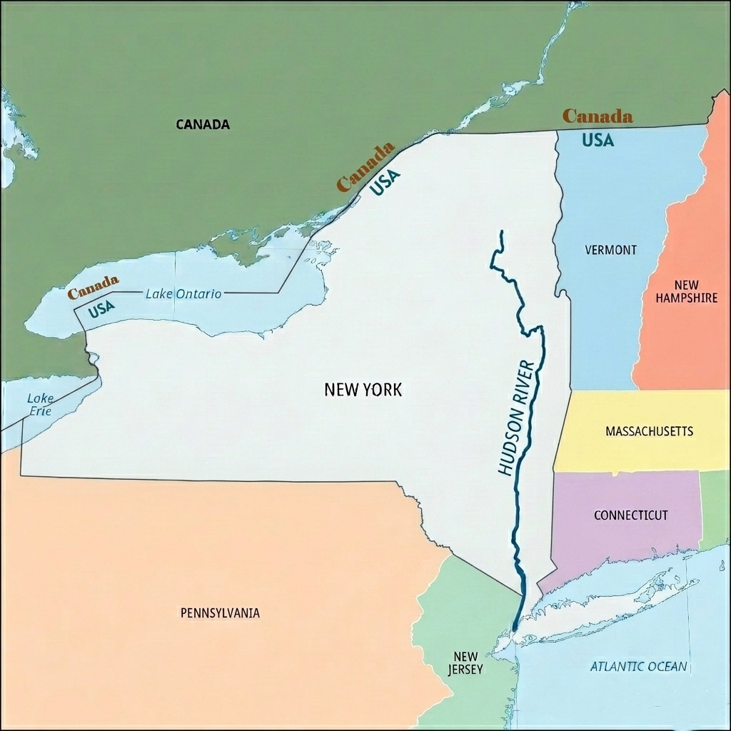
The Hudson River is a 315-mile river flowing through eastern New York State in the northeastern United States. It begins in the Adirondack Mountains at Lake Tear of the Clouds and flows generally southward before emptying into the Atlantic Ocean at New York Harbor. In its lower section, the river also forms part of the boundary between New York and New Jersey.
The course of the Hudson River is commonly divided into three major geographic sections: the Upper Course, the Middle Course, and the Lower Course.
1. Upper Course (Headwaters)
The Hudson River originates near Mount Marcy in the Adirondack Mountains, where a small stream flows out of Lake Tear of the Clouds. In this upper section, the river begins as a narrow, fast-flowing trout stream moving through rugged mountain terrain, forests, and rocky valleys.
From its source, the river follows a winding southeastward path through the Adirondack region toward Corinth. It then bends northeastward near Hudson Falls before eventually turning south at the Federal Dam in Troy. This upper section contains rapids, waterfalls, and steep gradients typical of a youthful mountain river.
One of the most important tributaries of the Hudson River is the Mohawk River, which joins the Hudson just north of Albany. The Mohawk River significantly increases the Hudson’s water volume and historically provided an important transportation route connecting the Atlantic coast with the interior of North America.
2. Middle Course (Hudson Valley)
Below Troy, the Hudson River enters its middle course and flows almost entirely southward for nearly 200 miles through the scenic Hudson River Valley. This region is one of the most famous landscapes in New York State and has played an important role in American history, art, agriculture, and trade.
In this section, the river flows between the Catskill Mountains to the west and the Taconic Mountains to the east. Farther south, the river cuts through the dramatic Hudson Highlands, a rugged extension of the Appalachian Mountain system known for its steep hills, cliffs, and scenic beauty.
A defining feature of the middle and lower Hudson is its tidal nature. Due to the influence of the Atlantic Ocean, tides affect the river as far north as Troy. Because of this, the lower Hudson functions as a tidal estuary or “drowned river,” where water levels and currents regularly rise and fall with ocean tides. Historically, Native American communities referred to it as the “river that flows both ways” because the tidal currents could reverse the river’s direction temporarily.
3. Lower Course (New York Harbor and Estuary)
South of the Hudson Highlands, the river broadens considerably and enters its lower course. In this section, the Hudson forms the boundary between New York and New Jersey and becomes heavily urbanized as it approaches the New York metropolitan area.
The river passes alongside the famous Palisades, a line of steep basalt cliffs rising dramatically above the western bank of the river. These geological formations are among the most recognizable natural landmarks in the region.
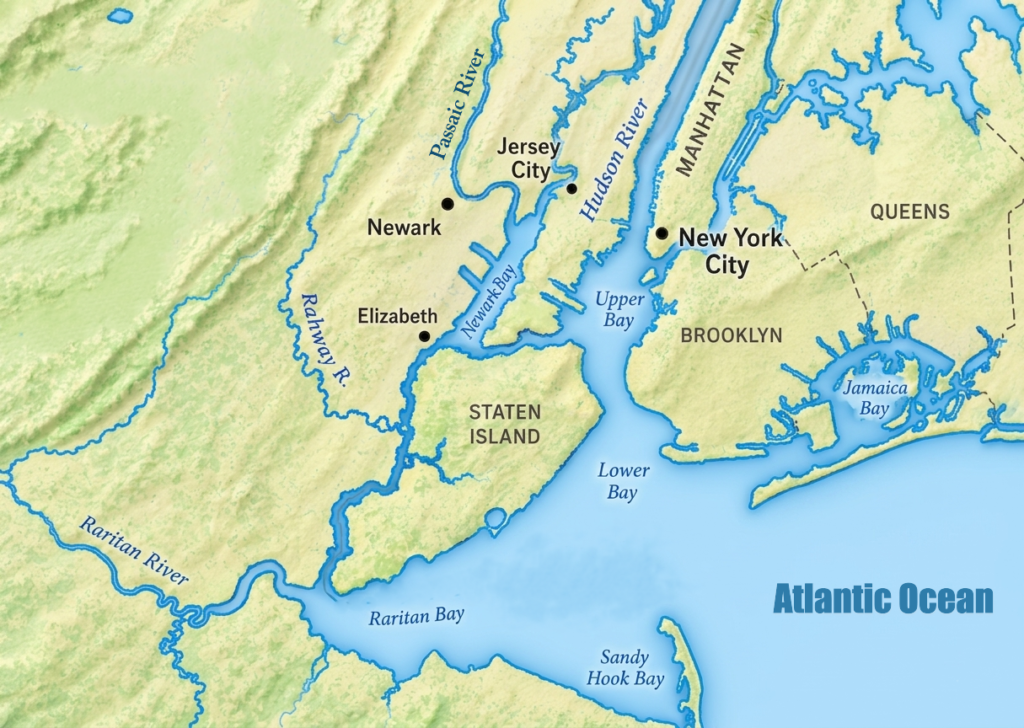
Farther south, the Hudson flows past Manhattan and Jersey City before entering New York Harbor. The river ultimately empties into the Atlantic Ocean through The Narrows, the narrow maritime passage connecting Upper and Lower New York Bay. This final section of the Hudson is one of the busiest and most economically important waterways in the United States.
Hudson River Estuary
The Hudson River Estuary is a 153-mile-long tidal estuary extending from the Federal Dam at Troy to Verrazzano-Narrows in New York City. It forms the lower portion of the Hudson River and is one of the largest freshwater tidal estuaries in the United States. Influenced by tides from the Atlantic Ocean, the estuary contains a constantly changing mixture of freshwater flowing from the north and saltwater moving inland from the ocean, creating a rich and highly productive aquatic ecosystem.
One of the most unique characteristics of the Hudson River Estuary is its strong tidal influence. Because the river drops only about five feet in elevation between Troy and the Atlantic Ocean, ocean tides travel all the way upstream to Troy. This causes the river’s water levels and currents to rise, fall, and even reverse direction twice each day. The Lenape people historically called the river Muhheakantuck or Mahicannituk, meaning “the waters that are never still” or “the river that flows both ways,” reflecting this unusual tidal behavior.
The boundary between freshwater and saltwater, known as the salt front, constantly shifts depending on rainfall, seasonal river flow, and drought conditions. In most years, this mixing zone lies between Yonkers and Newburgh. The estuary also contains extensive freshwater tidal marshes, mudflats, wetlands, and shallow bays that provide critical ecological functions such as water filtration, flood control, and shoreline stabilization.
The Hudson River Estuary supports exceptional biodiversity and serves as an important habitat for more than 200 fish species and many migratory birds. It is especially important as a spawning and nursery ground for fish such as striped bass, Atlantic sturgeon, American shad, and river herring. Wetlands and shoreline habitats along the estuary also form part of the Atlantic Flyway, making the region vital for seasonal bird migration.
Conservation and scientific research play a major role in protecting the estuary. The Hudson River National Estuarine Research Reserve manages protected areas including Piermont Marsh, Iona Island, Tivoli Bays, and Stockport Flats. These sites are used for environmental monitoring, habitat restoration, scientific research, and educational programs. The New York State Department of Environmental Conservation also operates the Hudson River Estuary Program, which works with regional partners to improve water quality, restore ecosystems, and support long-term watershed management.
The estuary is deeply connected to surrounding communities and provides numerous opportunities for boating, fishing, kayaking, hiking, and wildlife observation. Parks, waterfront trails, and greenways along the river attract millions of visitors each year while also supporting tourism and recreation. Today, the Hudson River Estuary remains one of the most important natural and cultural landscapes in the northeastern United States, balancing ecological conservation with urban development and human activity.
Hudson River Basin
The Hudson River Basin is the large watershed area drained by the Hudson River and its numerous tributaries. The basin stretches across much of eastern and central New York and also includes parts of Vermont, Massachusetts, Connecticut, and New Jersey. It contains a wide variety of landscapes, including the Adirondack Mountains, fertile valleys, forests, wetlands, lakes, and densely populated urban regions. The river system supports millions of people through water supply, agriculture, transportation, recreation, and industry.
According to the United States Geological Survey, the Hudson River Basin is commonly divided into three major sections based on geography and hydrological characteristics: the Upper Hudson River Basin, the Mohawk River Basin, and the Lower Hudson River Basin.
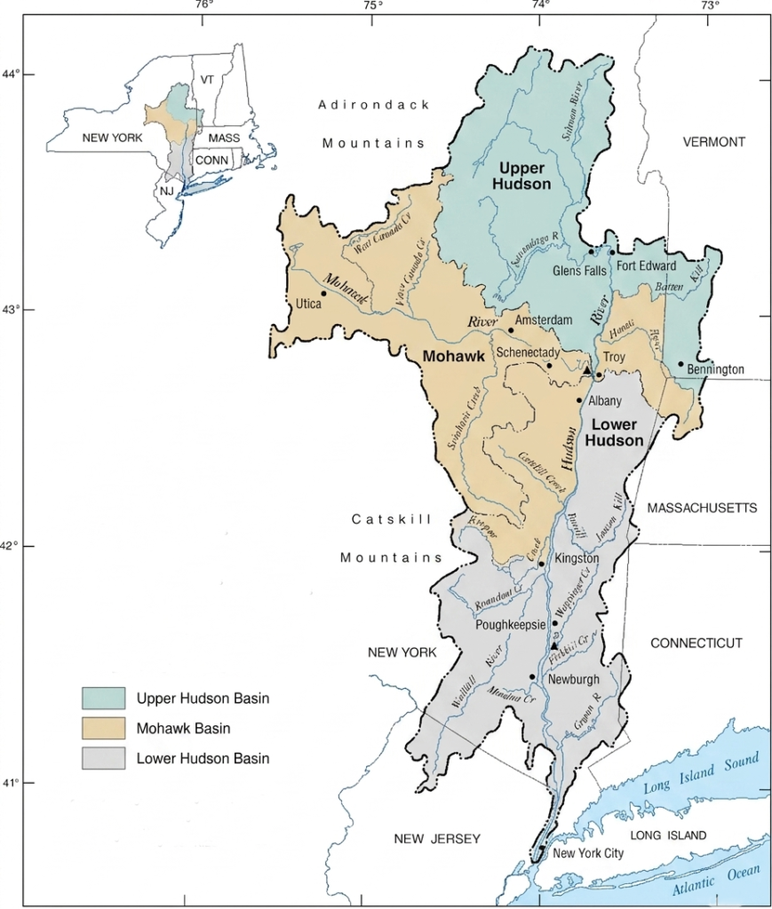
1. Upper Hudson River Basin
The Upper Hudson River Basin extends from the headwaters in the Adirondack Mountains southward to Troy. This northern region drains around 4,590 square miles and is dominated by forests, mountain lakes, rocky terrain, and wilderness areas located largely within Adirondack Park.
The Hudson River begins near Mount Marcy at Lake Tear of the Clouds, where a small stream known as Feldspar Brook joins the Opalescent River before forming the main river channel. In this upper course, the river descends more than 4,000 feet, creating swift currents, rapids, and waterfalls. The water in this section is cold, clear, and fast-moving, supporting healthy freshwater ecosystems.
The Upper Hudson Basin also contains 14 major dams that are used for hydroelectric power generation, flood control, and navigation management. These dams help regulate river flow and support regional infrastructure throughout eastern New York.
Several major tributaries feed the upper basin. The Sacandaga River is one of the largest tributaries and is controlled by the Conklingville Dam, which created Great Sacandaga Lake. The Schroon River drains northeastern Adirondack lakes and forests before joining the Hudson near Warrensburg. Other important tributaries include the Batten Kill and the Hoosic River, which originate in Vermont and Massachusetts.
2. Mohawk River Basin
The Mohawk River Basin forms the largest tributary system of the Hudson River and is often considered the western branch of the basin. The Mohawk River drains approximately 3,460 square miles of central New York before joining the Hudson near Cohoes.
This basin occupies a broad valley that cuts through the Appalachian Mountain system, creating one of the few natural east-west transportation corridors in the northeastern United States. Because of this strategic location, the valley became the route for the historic Erie Canal, which connected the Hudson River to the Great Lakes and played a major role in the economic growth of New York State.
The Mohawk Basin includes fertile agricultural land, historic canal towns, industrial cities, and rolling uplands. Major tributaries feeding the Mohawk River include the West Canada Creek and East Canada Creek, which bring cold freshwater from the southern Adirondacks. The Schoharie Creek drains the northern slopes of the Catskill Mountains before entering the Mohawk River. Smaller tributaries such as Oriskany Creek and Sauquoit Creek drain farmland and rural valleys across central New York.
3. Lower Hudson River Basin
The Lower Hudson River Basin stretches from Troy southward to New York Harbor and includes the tidal estuary section of the river. Unlike the upper river, this section lies close to sea level and is heavily influenced by Atlantic Ocean tides. As a result, water levels and currents change throughout the day, and in some areas the river can temporarily flow in both directions depending on tidal movement.
This section of the basin is surrounded by the Catskill Mountains to the west and the Hudson Highlands farther south. The region contains tidal wetlands, marshes, mudflats, urban waterfronts, and highly developed transportation corridors.
The northern part of the Lower Hudson Basin, extending from Troy to Wappingers Falls, remains entirely freshwater despite the tidal influence. Major tributaries in this section include the Fishkill Creek, Rondout Creek, and Wallkill River. Farther south, the river gradually becomes brackish as saltwater from the Atlantic mixes with freshwater from upstream. In this lower estuarine zone, important tributaries include the Croton River, which is an important part of New York City’s water supply system, and the Sparkill Creek.
The Hudson River Basin as a whole is an ecologically and economically important region that supports transportation, fisheries, agriculture, hydroelectric power, recreation, and millions of residents throughout the northeastern United States.
Tributaries of the Hudson River
The Hudson River is fed by a large network of rivers, creeks, streams, and watersheds throughout its 315-mile course from the Adirondack Mountains to New York Harbor. The river system contains more than 30 named tributaries, many of which originate in the Adirondack Mountains, Catskill Mountains, Taconic Range, and surrounding valleys. These tributaries supply freshwater, sediment, nutrients, and ecological diversity to the Hudson River Basin.
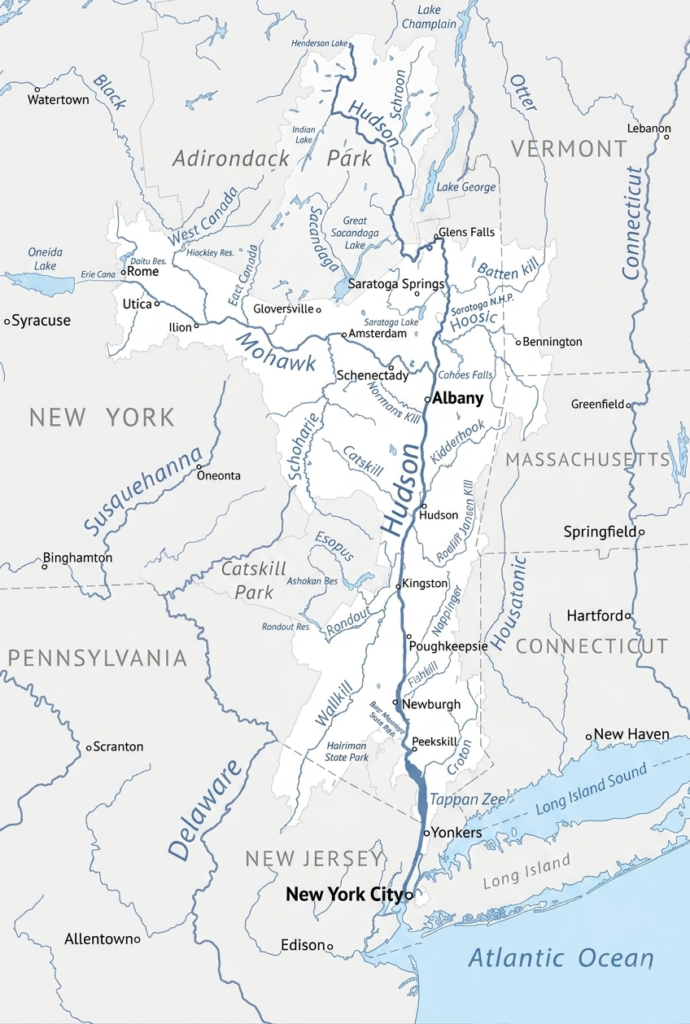
Tributaries of the Hudson are commonly classified according to the side of the river from which they enter — either the western (right-bank) side or the eastern (left-bank) side.
Right-Bank Tributaries (Western Side) of the Hudson River
The western side of the Hudson River receives water from several major tributaries flowing from the Adirondacks, Catskills, and western valleys of New York.
Mohawk River
The Mohawk River is the largest tributary of the Hudson River and one of the most historically important rivers in New York State. Stretching about 149 miles, it flows eastward across central New York before joining the Hudson near Cohoes. The Mohawk Valley forms a natural transportation corridor through the Appalachian Mountains and later became the route of the historic Erie Canal.
Sacandaga River
The Sacandaga River is a 64-mile-long tributary of the Hudson River located in the southern Adirondack Mountains of upstate New York. It flows southeasterly before being impounded by the Conklingville Dam, creating the 29-mile-long Great Sacandaga Lake. Below the dam, the river resumes its course for a short stretch before flowing into the Hudson River at Hadley.
Wallkill River
The Wallkill River is an 88.3-mile-long tributary of the Hudson River that flows generally northward from northern New Jersey into New York. Unique for its northward flow, it begins at Lake Mohawk in Sparta Township, NJ, and ultimately empties into Rondout Creek in New York to reach the Hudson River.
Esopus Creek
Esopus Creek is a 65.4-mile tributary in New York’s Catskill Mountains, flowing from Winnisook Lake to the Hudson River. It is famously divided by the Ashokan Reservoir into the trout-rich Upper Esopus and the lower warmwater section, serving as a major NYC water source and outdoor recreation hub.
Rondout Creek
Rondout Creek is a 63.3-mile-long tributary of the Hudson River in New York’s Ulster and Sullivan counties. Originating in the Catskill Mountains, it flows southeast through Ellenville, turns northeast over High Falls, and empties into the Hudson River at Kingston, famously passing the historic Rondout Lighthouse.
Left-Bank Tributaries (Eastern Side) of the Hudson River
The eastern side of the Hudson River receives tributaries flowing from the Taconic Mountains, Vermont highlands, and eastern valleys of New York and Massachusetts.
Croton River
The Croton River is a 40-km waterway in southern New York that flows into the Hudson River. Fed by three main tributaries, it forms a vital part of the New York City water supply system via the New Croton Reservoir and Gorge. The river is formed in Croton Falls where the East and West Branch tributaries meet, meandering through northern Westchester County before draining into the Hudson River.
Hoosic River
The Hoosic River is a 76-mile-long tributary of the Hudson River that flows northwestward from the Berkshires in Massachusetts, briefly into southern Vermont, and across eastern New York. It empties into the Hudson River about 15 miles north of Troy, near Stillwater. Known for its scenic valleys, varied recreational paddling, and flood-control infrastructure, it serves as a prominent waterway for both outdoor enthusiasts and local communities.
Batten Kill
The Batten Kill (or Battenkill River) is a scenic 59.4-mile-long river that flows from its source in East Dorset, Vermont, southwest into New York, where it eventually empties into the Hudson River. It is celebrated for its world-class trout fishing and recreational activities like tubing and kayaking.
Schroon River
The Schroon River is a 67.7-mile-long recreational tributary of the Hudson River located entirely within the Adirondack Park in upstate New York. Flowing from Underwood to Warrensburg, it is highly regarded for kayaking, premier trout fishing, and scenic Adirondack camping.
Kinderhook Creek
Kinderhook Creek is a scenic, 49-mile-long tributary in upstate New York that flows from the Taconic Mountains in Massachusetts down to the Hudson River. It is highly regarded for its thriving brown trout fishery, peaceful hiking trails, and stunning autumn foliage.
History of the Hudson River
The Hudson River has played a central role in the history, culture, economy, and development of the northeastern United States for thousands of years. Carved by glaciers during the last Ice Age around 20,000 years ago, the river stretches approximately 315 miles from the Adirondack Mountains to New York Harbor.
Over time, it became an important transportation route for Native American communities, a major colonial trade corridor, a strategic military waterway during the American Revolution, and later a center of commerce, art, and environmental activism.
Indigenous Roots and Early Exploration
Long before European explorers arrived, the Hudson River Valley was inhabited by Indigenous Algonquian-speaking peoples. The southern portion of the river was home mainly to the Lenape, especially the Munsee Lenape communities, while the northern valley was inhabited by the Mahican people. These communities depended heavily on the river for fishing, hunting, agriculture, and transportation.
The deep tidal estuary allowed Native Americans to travel efficiently along the river using canoes, while surrounding forests and wetlands provided abundant natural resources. The Lenape referred to the river as Muhheakantuck, meaning “the river that flows both ways,” because of the tidal currents that reverse direction daily.
European contact began in the early 16th century. In 1524, Italian explorer Giovanni da Verrazzano became the first European known to sight the entrance of the river while exploring the Atlantic coast for France. However, it was not until 1609 that English navigator Henry Hudson, sailing for the Dutch East India Company, traveled up the river in search of a northwest passage to Asia. His voyage established Dutch claims in the region and led to the creation of the colony of New Netherland.
Dutch Colonization and Settlement
Following Hudson’s expedition, Dutch traders and settlers established trading posts and settlements along the river. The Hudson quickly became the commercial backbone of New Netherland, supporting the fur trade and agricultural development.
Settlements such as Albany and New York City grew into important colonial centers because of their access to the river. Dutch influence remained strong throughout the valley even after the English seized control of New Netherland in 1664.
The Hudson River During the American Revolution
During the American Revolutionary War, the Hudson River became one of the most strategically important waterways in North America. British military leaders believed that controlling the river would allow them to separate New England from the southern colonies, weakening the revolutionary movement.
Several major military sites and battles were connected to the Hudson River corridor. The Americans established defensive fortifications and heavy iron chains across the river at West Point to block British naval movements. The river valley also witnessed the important Battles of Saratoga, where American forces achieved a decisive victory over the British. This victory is often considered a turning point in the war because it helped secure French support for the American cause.
Trade, Transportation, and Industrial Expansion
The Hudson River became even more important during the 19th century as transportation and trade expanded rapidly. One of the most transformative developments was the opening of the Erie Canal in 1825. The canal connected the Hudson River to the Great Lakes, creating a direct water route between the Atlantic Ocean and the interior of North America.
This connection turned New York City into the leading commercial gateway of the United States and accelerated westward expansion, immigration, and economic growth. Goods from the Midwest could now be transported efficiently to eastern ports through the Hudson River corridor.
Throughout the 19th and early 20th centuries, the river became a major transportation hub filled with steamships, tugboats, ferries, and cargo barges. Factories, mills, railroads, and industrial cities developed along its banks, making the Hudson Valley one of the country’s most important industrial regions.
The Hudson River School and Cultural Influence
In the 1800s, the dramatic scenery of the Hudson Valley inspired an influential American art movement known as the Hudson River School. Artists associated with this movement painted landscapes featuring the river, forests, waterfalls, mountains, and dramatic skies of the Hudson Valley and Catskills.
Natural landmarks such as the Palisades and the Catskill Mountains became symbols of American natural beauty. The movement played a major role in shaping early American landscape painting and increasing public appreciation for wilderness and conservation.
Environmental Challenges and Conservation
By the mid-20th century, rapid industrialization and urban growth had severely polluted the Hudson River. Industrial waste, sewage, and chemical contamination damaged ecosystems and threatened public health throughout the river valley.
One of the most important moments in modern environmental history occurred in 1963 when a proposed power plant project at Storm King Mountain sparked widespread public opposition. The legal battle that followed lasted for nearly 18 years and eventually led to the formation of the environmental organization Scenic Hudson. The case established important legal precedents for environmental protection and citizen involvement in conservation decisions across the United States.
Cleanup efforts, environmental regulations, and habitat restoration projects gradually improved water quality in the Hudson River during the late 20th and early 21st centuries.
The Hudson River in the Modern Era
Today, the Hudson River is both an important economic corridor and a major center for recreation, tourism, and environmental restoration. Waterfront parks, greenways, trails, and conservation projects have transformed many former industrial areas into public recreational spaces.
The river continues to support shipping, transportation, fishing, boating, and tourism while also serving as an important ecological habitat. The Hudson has additionally become part of modern American history through notable events such as the emergency landing of US Airways Flight 1549 emergency landing in 2009, often called the “Miracle on the Hudson,” when a passenger airplane safely landed on the river after striking birds shortly after takeoff.
From Indigenous settlements to colonial trade, revolutionary battles, industrial expansion, artistic inspiration, and environmental activism, the Hudson River has remained one of the most historically significant waterways in the United States.
Cities Along the Hudson River
The Hudson River passing through numerous historic cities, towns, and riverfront communities along the way. Over centuries, these settlements developed because of the river’s importance for transportation, trade, industry, government, and commerce. Today, the Hudson River corridor includes state capitals, industrial centers, artistic communities, tourist destinations, and some of the most densely populated urban waterfronts in the United States.
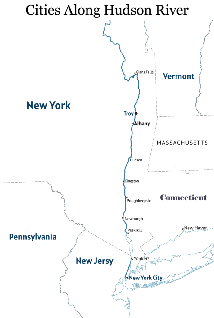
The cities along the Hudson River are commonly grouped into three major regions: the Upper Hudson and Capital District, the Mid-Hudson Valley, and the Lower Hudson and New York metropolitan waterfront.
The Capital District and Upper Hudson Cities
The upper portion of the Hudson River includes several historically important cities connected to New York’s colonial, industrial, and political development.
Troy
Troy is located near the head of the tidal section of the Hudson River and was once one of America’s leading industrial centers during the 19th century. Known for its historic architecture and manufacturing heritage, Troy played an important role in iron production, textiles, and trade along the river.
Albany
Albany, the capital of New York State, sits on the western bank of the Hudson River and has long been one of the region’s most important political and commercial centers. Founded during the Dutch colonial period, Albany became a key transportation hub because of its strategic location linking the Hudson River with the Erie Canal and inland trade routes.
Hudson
Hudson is a smaller riverfront city known for its preserved 19th-century architecture, antique shops, art galleries, restaurants, and cultural tourism. Located in the scenic Hudson Valley, the city has become a popular destination for artists, visitors, and weekend travelers from New York City.
Cities of the Mid-Hudson Valley
The Mid-Hudson Valley contains some of the river’s most scenic and culturally vibrant communities, surrounded by mountains, forests, and historic landscapes.
Kingston
Kingston was the first capital of New York State and remains one of the Hudson Valley’s most historic cities. Its waterfront district along Rondout Creek developed into an important shipping and canal center during the 19th century. Today, Kingston is known for its arts community, historic neighborhoods, and revitalized waterfront.
Poughkeepsie
Poughkeepsie is one of the largest cities in the Mid-Hudson region and serves as an important transportation, business, and educational center. The city is especially famous for the Walkway Over the Hudson, a former railroad bridge converted into one of the world’s longest elevated pedestrian walkways.
Beacon
Beacon has become one of the Hudson Valley’s most recognized arts destinations. Once an industrial city, Beacon experienced major revitalization and is now known for the Dia Beacon contemporary art museum, galleries, restaurants, and scenic riverfront setting.
Peekskill
Peekskill is an important cultural and residential city in Westchester County along the lower Hudson Valley. The city is known for its historic downtown, arts community, and the Paramount Hudson Valley Theater, a major entertainment venue in the region.
Lower Hudson and New York Metropolitan Waterfront Cities
As the Hudson River approaches the Atlantic Ocean, the riverfront becomes increasingly urbanized and densely populated. This lower section contains major cities and waterfront districts that form part of the New York metropolitan area.
Yonkers
Yonkers is the fourth-most populous city in New York State and the largest city in Westchester County. Located directly north of New York City, Yonkers has transformed many former industrial waterfront areas into parks, residential developments, and entertainment districts along the Hudson River.
Jersey City
Jersey City lies across the Hudson River from Lower Manhattan and is one of New Jersey’s largest economic and residential centers. Its waterfront skyline, transportation connections, and proximity to New York City have made it one of the fastest-growing urban areas in the region.
Hoboken
Hoboken is a densely populated waterfront city famous for its scenic Hudson River views and vibrant urban atmosphere. The city’s Hudson River Waterfront Walkway offers panoramic views of the Manhattan skyline and serves as a popular recreational area.
New York City
New York City marks the final stage of the Hudson River before it enters the Atlantic Ocean. The river flows past the boroughs of Manhattan and Bronx before emptying into New York Harbor. The Hudson River waterfront has played a major role in the city’s history as a center of immigration, trade, shipping, transportation, and global commerce.
Dams on the Hudson River
The Hudson River contains a variety of dams, locks, reservoirs, and water-control structures that play important roles in flood management, navigation, hydroelectric power generation, and water supply. Unlike many large rivers in the United States, the lower Hudson River is a tidal estuary rather than a continuously dammed waterway. As a result, most major dams are concentrated in the Upper Hudson region and along important tributaries rather than on the main lower river itself.
From small historic structures near the Adirondack headwaters to major canal and reservoir systems in eastern New York, Hudson River dams have significantly shaped the river’s ecology, transportation system, and economic development.
Dams on the Main Hudson River
Federal Dam and Troy Lock
The most important structure on the main Hudson River is the Federal Dam, located near river mile 153 in Troy. Completed in 1916 by the United States Army Corps of Engineers, the dam marks the upper boundary of the tidal Hudson River estuary and represents the furthest point upstream affected by Atlantic Ocean tides.
Attached to the dam is the Troy Lock, also known as the Federal Lock, which allows commercial vessels, barges, and recreational boats to bypass the dam and access the New York State Canal System, including the Erie Canal and Champlain Canal. The Federal Dam remains one of the most strategically important navigation structures in New York State.
Upper Hudson River Dams
Farther north in the Upper Hudson Basin, the river is influenced by several hydroelectric and reservoir dams designed to regulate water flow, reduce flooding, and support industrial activity. These structures help manage seasonal runoff from the Adirondack Mountains and stabilize water levels downstream.
One of the most notable dams is the Spier Falls Dam, a hydroelectric facility located north of Glens Falls. The dam generates electricity and creates a reservoir along the upper river.
Another important structure is the Feeder Dam, which historically supplied water to the Champlain Canal system and played a major role in regional transportation during the canal era.
The Northumberland Dam also contributes water to the Champlain Canal and helps regulate river flow in the Upper Hudson region.
Major Dams on Hudson River Tributaries
Because the lower Hudson River is strongly tidal for much of its length, many major water-control projects are located on tributaries rather than on the main river itself. Tributary dams are especially important for flood control, drinking water supply, and hydroelectric generation.
New Croton Dam
The New Croton Dam is one of the largest and most visually impressive masonry dams in the northeastern United States. Built on the Croton River, a major tributary of the Hudson, the dam created the New Croton Reservoir, which became a critical component of the New York City water supply system.
Completed in the early 20th century, the structure is known for its massive stone construction, spillway design, and engineering significance. It continues to supply drinking water to millions of residents in the New York metropolitan region.
Conklingville Dam
The Conklingville Dam is located on the Sacandaga River, one of the Hudson River’s largest tributaries. Built primarily for flood control, the dam created Great Sacandaga Lake, a large reservoir in the southeastern Adirondacks.
The dam plays a crucial role in regulating water entering the Hudson River Basin and helps reduce flooding in downstream communities along the Hudson Valley. It also supports recreation, tourism, and regional water management.
Ports on the Hudson River
The Hudson River has served as one of the most important commercial waterways in the northeastern United States for centuries. The river connects inland New York to the Atlantic Ocean through a deep-water navigation channel extending as far north as Albany. Along its course, the Hudson supports a wide range of ports, terminals, ferry hubs, industrial waterfronts, and recreational marinas.
The ports along the Hudson River vary greatly in size and function. Some operate as international cargo facilities handling bulk goods and heavy industrial materials, while others serve primarily as commuter ferry terminals, recreational marinas, or regional transportation centers. Together, these ports form a vital transportation and economic corridor linking upstate New York with the New York metropolitan area and global shipping networks.
1. Port of Albany–Rensselaer
The Port of Albany-Rensselaer is the northernmost deep-water port on the Hudson River and is located about 150 miles north of New York City. Situated along both Albany and Rensselaer, the port serves as a major year-round international shipping facility connected directly to the New York State Canal System and regional freight rail networks.
The port operates along a 32-foot navigation channel and handles a wide range of cargo, including grain, steel, wood pulp, heavy machinery, and wind turbine components. Because of its inland location and multimodal transportation links, the port plays an important role in industrial shipping and large infrastructure projects throughout the northeastern United States.
2. Port of Coeymans
Located south of Albany, the Port of Coeymans is a privately operated marine terminal and industrial complex along the western bank of the Hudson River. The port specializes in modular construction logistics, heavy rigging operations, and bulk cargo handling such as scrap metal, stone aggregates, and industrial materials.
Its large industrial footprint and river access have made it an important staging area for major infrastructure and energy projects across the Northeast. The port has also expanded its role in handling oversized industrial equipment and specialized cargo shipments.
3. Port of Newburgh
The Port of Newburgh is located in the Mid-Hudson Valley and historically served as an important shipping and distribution center for regional goods moving along the Hudson River. Today, the waterfront functions primarily as a mixed-use riverfront area that supports recreational boating, regional tug and barge operations, and commuter transportation.
The port area includes marinas, ferry facilities, restaurants, and waterfront recreation spaces. Ferry services connecting Newburgh and Beacon provide important transportation links for commuters traveling across the river.
4. Port Imperial
Port Imperial is one of the busiest commuter ferry terminals on the Hudson River. Located on the western bank of the Lower Hudson in Weehawken, New Jersey, the terminal serves as a major hub for NY Waterway ferry operations.
Thousands of commuters travel daily between New Jersey waterfront communities and Manhattan using the terminal’s ferry services. The port also provides direct connections to buses, light rail systems, and nearby residential and commercial developments along the New Jersey waterfront.
5. Chelsea Piers and Pier 79
Located on Manhattan’s west side within Hudson River Park, Chelsea Piers and Pier 79 serve important recreational and passenger transportation functions along the Lower Hudson River.
Pier 79 acts as a major ferry terminal supporting commuter services, sightseeing cruises, and tourism-related river traffic. Nearby Chelsea Piers has been redeveloped into a large sports, entertainment, and recreation complex while also accommodating recreational vessels and marina facilities.
6. Hoboken Terminal
Hoboken Terminal is one of the most important transportation hubs along the Hudson River waterfront. Located in Hoboken, the terminal combines commuter rail, buses, light rail, and ferry operations within a historic landmark complex.
Its ferry slips provide direct transportation connections between New Jersey and Manhattan, making it a critical part of the regional commuter network serving the New York metropolitan area.
7. Paulus Hook Ferry Terminal
The Paulus Hook Ferry Terminal is located in the financial district of Jersey City along the western bank of the Hudson River. The terminal handles high volumes of commuter passenger traffic and provides direct ferry connections to Lower Manhattan destinations such as Wall Street and Brookfield Place. Its strategic location within Jersey City’s rapidly growing business district has made it one of the busiest passenger ferry terminals on the river.
8. Port of New York and New Jersey
At the mouth of the Hudson River lies the massive Port of New York and New Jersey, the largest port complex on the East Coast of the United States. Located around New York Harbor and the Upper Bay, the port system serves as the primary maritime gateway for the northeastern United States.
The port handles enormous volumes of international cargo, including container ships, petroleum products, automobiles, bulk commodities, and cruise passengers. While parts of the port extend into Newark Bay and surrounding waterways, the Hudson River entrance remains one of the most important shipping channels in North America.
Economic Importance of the Hudson River
The Hudson River is one of the most economically important waterways in the United States. The river has shaped the economic development of New York State and the broader Northeast for centuries. By connecting the Atlantic Ocean to inland North America through the Erie Canal and the New York State Canal System, the Hudson River helped transform New York City into one of the world’s leading commercial and financial centers.
Today, the river continues to support shipping, tourism, transportation, agriculture, fisheries, real estate, and industrial development while generating billions of dollars for the regional economy.
Port and Shipping Economy
The lower Hudson River forms a major part of the Port of New York and New Jersey, the largest port complex on the East Coast of the United States. The river serves as a vital commercial shipping route connecting global maritime trade with inland New York and the northeastern United States.
Large commercial vessels transport billions of dollars worth of cargo through the Hudson River corridor every year, including petroleum, consumer goods, automobiles, chemicals, construction materials, and industrial products. The river remains connected to inland waterways through the Erie Canal system, continuing its historic role as a transportation route between the Atlantic Ocean and the continental interior.
Important inland ports such as the Port of Albany-Rensselaer and the Port of Coeymans also support heavy industry, bulk cargo movement, and infrastructure projects throughout the Northeast.
Tourism and Recreation
The Hudson River Valley is one of the most important tourism regions in the northeastern United States. Millions of visitors travel to the area each year to experience scenic riverfront landscapes, historic towns, cultural attractions, hiking trails, wineries, and outdoor recreation.
Tourism spending in the Hudson Valley generates billions of dollars annually and supports thousands of jobs in hotels, restaurants, transportation, entertainment, and recreation. Riverfront cities such as Beacon, Kingston, and Hudson have benefited greatly from tourism-driven economic growth.
The river also supports recreational activities such as boating, kayaking, sailing, fishing, river cruises, and wildlife observation. Popular destinations including Walkway Over the Hudson and Hudson River Park attract large numbers of visitors throughout the year.
Real Estate and Urban Development
The Hudson River waterfront contains some of the most valuable real estate in the northeastern United States. Scenic river views, transportation access, and proximity to major business districts have encouraged large-scale residential and commercial development along the river.
Luxury housing projects, office towers, mixed-use developments, and revitalized waterfront districts have transformed many former industrial areas into modern urban centers. Cities such as Jersey City, Hoboken, and Yonkers have experienced rapid growth because of their Hudson River waterfront locations.
The lower Hudson corridor has also become an important corporate and technology hub, with businesses attracted by transportation connectivity and access to the New York metropolitan market.
Fisheries and Agriculture
The Hudson River estuary continues to support important fish habitats and fisheries despite historical environmental challenges. Species such as striped bass, Atlantic sturgeon, shad, and river herring use the estuary as spawning and nursery grounds.
Recreational fishing remains economically important throughout the river system, while conservation and cleanup projects have helped improve water quality and aquatic habitats in recent decades.
The fertile Hudson Valley also supports a productive agricultural economy. Farms throughout the region produce fruits, vegetables, dairy products, and specialty crops for nearby urban markets. The valley is particularly known for apple orchards, vineyards, wineries, and fresh produce that supply the New York metropolitan region.
Water Supply and Transportation Infrastructure
The Hudson River and its tributaries provide important water resources for municipalities, industries, and power facilities throughout New York State. Tributaries such as the Croton River are essential components of the New York City water supply system.
The river corridor also contains major transportation infrastructure, including bridges, tunnels, highways, railroads, ferry terminals, and commuter rail systems that connect communities on both sides of the river. Millions of people depend on Hudson River transportation networks every year for commuting, commerce, and regional travel.
The Hudson River’s combination of shipping access, transportation infrastructure, tourism, urban development, agriculture, and natural resources continues to make it one of the most economically valuable waterways in North America.
Wildlife and Ecosystem of the Hudson River
The Hudson River supports one of the most diverse river ecosystems in the northeastern United States. Flowing from the Adirondack Mountains to New York Harbor, the river passes through forests, wetlands, tidal marshes, estuaries, and urban waterfronts that provide habitats for hundreds of species of fish, birds, reptiles, mammals, and aquatic organisms.
Because the Hudson River functions as a tidal estuary for much of its lower course, freshwater from inland New York continuously mixes with saltwater from the Atlantic Ocean. This unique environment allows both freshwater species and marine organisms to thrive within the same river system. The Hudson River estuary serves as an important spawning ground, migration corridor, nursery habitat, and feeding area for wildlife throughout the Atlantic coast region.
Fish and Aquatic Life
The Hudson River contains more than 200 species of fish and aquatic organisms, making it one of the richest estuarine ecosystems on the Atlantic coast. The river’s combination of freshwater, brackish water, and tidal habitats supports both resident species and migratory marine fish.
Among the most iconic fish species in the Hudson are striped bass, which migrate into the estuary each spring to spawn. The river is also well known for American shad, Atlantic sturgeon, shortnose sturgeon, and American eel. Sturgeon are especially significant because they are among the oldest surviving fish species in North America and use the Hudson estuary as an important breeding habitat.
The river bottom and tidal marshes support a wide variety of smaller aquatic creatures, including blue crabs, grass shrimp, mud crabs, and freshwater mussels. These organisms play a critical role in the river’s food web by supporting fish, birds, and larger predators.
Closer to the lower estuary and New York Harbor, saltwater influence allows marine species to enter the river seasonally. Starfish, seahorses, jellyfish, and other marine organisms are sometimes found in brackish waters near the harbor. Marine mammals such as harbor seals are also increasingly common during colder months, particularly near the lower Hudson River and surrounding estuary.
Birdlife Along the Hudson River
The Hudson River is one of the most important bird migration corridors in the northeastern United States. Its wetlands, shorelines, cliffs, forests, and open waters provide feeding and nesting habitats for numerous bird species throughout the year.
Birds of prey are especially prominent along the river. Bald eagle populations have recovered significantly in recent decades and are now regularly seen hunting fish along the Hudson Valley. Peregrine falcon are also frequently observed nesting on cliffs, bridges, and urban structures near the river.
The river’s marshes and tidal flats support many species of waterfowl and shorebirds. Great blue herons, cormorants, egrets, gulls, ducks, and geese are common throughout the estuary. During migration seasons, thousands of birds travel along the Hudson flyway while using the river’s wetlands as resting and feeding grounds.
Areas such as the Hudson River Estuary and surrounding conservation lands are considered critical habitats for migratory birds and wetland-dependent species.
Reptiles and Amphibians
The marshes, tributaries, ponds, and wetlands surrounding the Hudson River support a variety of reptiles and amphibians adapted to both freshwater and brackish environments.
One of the most notable reptile species in the lower estuary is the Diamondback terrapin, which inhabits tidal marshes and brackish coastal waters. In freshwater areas farther upstream, snapping turtles and eastern painted turtles are commonly found in ponds, streams, and slow-moving river sections.
Amphibians such as frogs and salamanders also inhabit wetland environments throughout the Hudson River Basin, especially within forested tributaries and marsh ecosystems.
Mammals of the Hudson River Region
The Hudson River corridor supports a wide range of mammals, particularly in wetlands, forests, and tidal habitats along the riverbanks. Semi-aquatic mammals such as muskrats and North American river otter are commonly found in marshes and tributary streams where they feed on fish and aquatic organisms.
Beavers are also present in parts of the watershed, particularly in quieter tributaries and wetland systems. White-tailed deer, raccoons, foxes, and other mammals inhabit forests and riverfront habitats throughout the Hudson Valley.
Marine mammals occasionally travel into the lower Hudson estuary from the Atlantic Ocean. Harbor seals are the most frequently observed marine mammals, especially during winter months. In rare cases, dolphins and even whales have been spotted traveling into the river near New York Harbor.
Frequently Asked Questions about Hudson River
Where is the Hudson River?
The Hudson River is located in eastern New York State in the northeastern United States. It flows south from the Adirondack Mountains through the Hudson Valley and forms part of the border between New York and New Jersey before emptying into New York Harbor and the Atlantic Ocean.
Where does the Hudson River start and end?
The Hudson River begins at Lake Tear of the Clouds in the Adirondack Mountains near Mount Marcy. It flows south for about 315 miles before ending at New York Harbor, where its waters enter the Atlantic Ocean through The Narrows.
How long is the Hudson River?
The Hudson River is approximately 315 miles (507 kilometers) long from its source in the Adirondack Mountains to its mouth at New York Harbor.
How deep is the Hudson River?
The Hudson River has an average depth of about 30 feet (9.1 meters), although its depth varies greatly along different sections of the river. In many places, the river ranges between 30 and 200 feet deep. The deepest known section, called “World’s End,” near West Point, reaches depths of about 200 feet.
How deep is the Hudson River in NYC?
In the immediate New York City area, the Hudson River has a maintained commercial shipping channel depth ranging from approximately 40 to 48 feet. While the average depth of the Hudson estuary is around 30 feet, actual depths vary considerably depending on the location, tidal conditions, and navigation channels used by large commercial vessels.
Can you swim in the Hudson River?
Yes, swimming is allowed in certain parts of the Hudson River, especially during organized events or at designated riverfront parks and beaches. However, swimming conditions vary depending on water quality, tides, currents, and local regulations.
Is it safe to swim in the Hudson River?
Swimming in the Hudson River can be safe in some locations and conditions, but safety depends on water quality, weather, strong currents, and boat traffic. Local authorities often monitor bacteria levels and issue advisories when conditions are unsafe. Swimmers should always check local guidance before entering the river.
Is the Hudson River saltwater?
The Hudson River is both freshwater and saltwater. The upper river is freshwater, while the lower 153 miles function as a tidal estuary where freshwater from inland New York mixes with saltwater from the Atlantic Ocean.
Are there sharks in the Hudson River?
Yes, sharks can occasionally enter the lower Hudson River, especially near New York Harbor where saltwater conditions exist. Species such as sand tiger sharks, bull sharks, and dogfish sharks have been reported in the estuary, although shark encounters are rare and usually occur near the river’s mouth.