The Colorado River is a critical 1,450-mile-long (6th longest in the U.S.) river in western North America that originates in the Rocky Mountains and flows through seven U.S. states and two Mexican states. Famous for carving dramatic landscapes such as the Grand Canyon, the river supplies water and hydroelectric power to more than 40 million people and irrigates nearly 5 million acres of farmland across the American Southwest.
Despite its importance, the Colorado River faces severe environmental pressure. Heavy agricultural use, extensive dam construction, growing urban demand, and a long-term megadrought have significantly reduced its flow. As a result, the river’s waters now rarely reach their historic outlet at the Gulf of California in Mexico.
Table of Contents
Origin of Colorado River
The Colorado River begins at La Poudre Pass Lake in Rocky Mountain National Park in north-central Colorado. Located at an elevation of 10,184 feet above sea level, the river is fed by Rocky Mountain snowmelt and flows southwest toward the Gulf of California.
Course of Colorado River
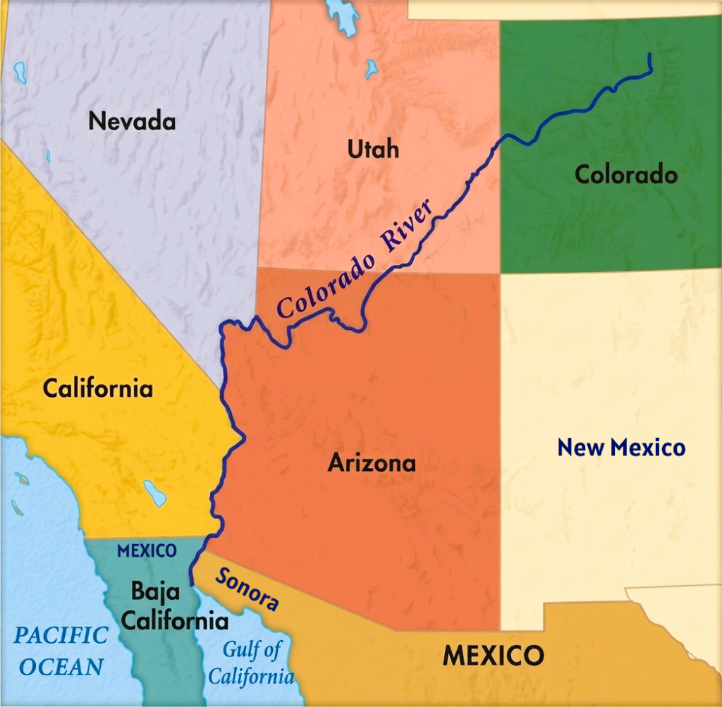
The Colorado River flows approximately 1,450 miles from the Rocky Mountains of Colorado to the Gulf of California in Mexico. Along its journey, the river passes through mountains, deep canyons, desert plateaus, and arid valleys while supporting millions of people across the American Southwest. The river’s course is commonly divided into the Upper Course, Middle Course and Lower Course Section.
Colorado River Upper Course
The upper course begins at La Poudre Pass Lake in Rocky Mountain National Park at an elevation of about 10,184 feet above sea level. In its early stages, the river flows as a cold mountain stream through the Kawuneeche Valley in north-central Colorado. Snowmelt from the Rocky Mountains feeds the river, making seasonal snowpack critically important to the entire basin.
From Colorado’s Western Slope, the river flows southwest through Colorado and Utah across the Colorado Plateau. Along this stretch, the river cuts through steep alpine valleys, high desert canyons, and rock formations. Near Grand Junction, it receives water from the Gunnison River, one of its major tributaries.
As the river enters Utah, it passes through Canyonlands National Park and merges with the Green River, its largest tributary. This section also includes famous canyon systems such as Cataract Canyon and Glen Canyon. The upper course ends at Lees Ferry in northern Arizona, which serves as the official dividing point between the Upper Basin and Lower Basin for water management.
One of the most important structures along this section is Glen Canyon Dam, which forms Lake Powell, the second-largest man-made reservoir in the United States.
Colorado River Middle Course
The middle course begins below Lake Powell at Lees Ferry and is dominated by the river’s passage through the Grand Canyon. Over millions of years, the Colorado River carved this massive canyon through layers of rock, creating a gorge approximately 277 miles long and up to 6,000 feet deep.
In this section, the river transforms into a powerful whitewater system with strong rapids, narrow rock walls, and steep gradients. Famous rapids such as Lava Falls Rapids are found here, separated by calmer stretches of water. The river carries large amounts of sediment, which continuously erode and deepen the canyon landscape.
The middle course ends near Hoover Dam, where the river is controlled to form Lake Mead near Las Vegas, Nevada.
Colorado River Lower Course
The lower course of the Colorado River begins below Hoover Dam and extends to the river’s historic mouth at the Gulf of California in Mexico. Near Las Vegas, the river turns south and flows through the arid landscapes of Nevada, Arizona, and California. In this section, the river becomes broader and slower as it crosses the scorching Sonoran and Colorado deserts.
The river forms parts of the Arizona-Nevada and Arizona-California borders while supporting some of the most heavily irrigated agricultural regions in the American Southwest. Major reservoirs in this section include Lake Mead, which stores water for millions of people and generates hydroelectric power. Dams, canals, and reservoirs throughout the lower basin regulate the river for irrigation, flood control, and urban water supply.
Large engineering projects aggressively divert water from the river in this section. One of the most important structures is the Imperial Diversion Dam, which channels much of the remaining river water into the All-American Canal. This canal supplies irrigation water to California’s Imperial Valley, one of the most productive farming regions in the United States. Major tributaries in the lower basin include the Gila River, Salt River, and Virgin River.
After crossing the U.S.-Mexico border near Yuma (Arizona), the river flows between the Mexican states of Sonora and Baja California toward the Colorado River Delta. Historically, the river emptied into the Gulf of California and supported a vast wetland ecosystem.
Today, however, the river’s flow in Mexico is greatly reduced because of heavy upstream water diversion in both the United States and Mexico. Much of the remaining water is diverted at Morelos Dam for agricultural use. As a result, the lower river and delta are often dry, and the Colorado River rarely reaches the Gulf of California naturally.
Colorado River Delta
The Colorado River Delta is one of the most important desert delta ecosystems in North America. It is located in northwestern Mexico where the Colorado River historically flowed into the Gulf of California, also known as the Sea of Cortez. The delta lies mainly between the Mexican states of Baja California and Sonora and represents the final stage of the Colorado River’s long journey from the Rocky Mountains to the sea.
Historically, the Colorado River Delta was a vast region of wetlands, marshes, riparian forests, lagoons, mudflats, and distributary channels. It supported rich biodiversity and created a fertile environment in the middle of the desert. The surrounding landscape is dominated by the Sonoran Desert, one of the hottest and driest deserts in North America. Despite the harsh desert climate, the regular flow of freshwater from the Colorado River once supported vegetation and abundant wildlife throughout the delta region.
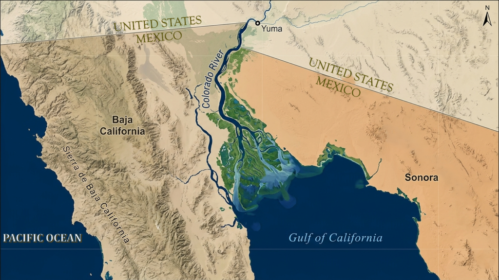
The delta was formed over millions of years through the deposition of sediment carried by the Colorado River. Seasonal floods transported enormous quantities of sand, silt, and clay from the Rocky Mountains and the Colorado Plateau into the northern Gulf of California. As the river slowed near its mouth, these sediments settled and gradually built a broad fan-shaped delta plain. Over time, the river frequently changed its channels across the floodplain, creating a complex network of wetlands and distributaries.
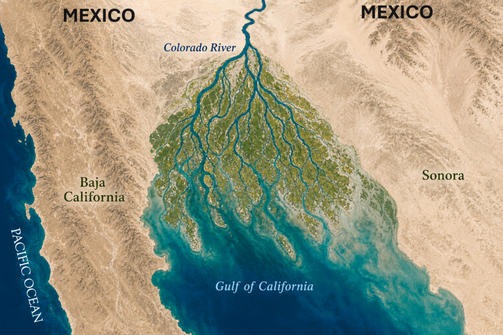
Before large dams were constructed, annual spring floods regularly replenished the delta with freshwater and nutrient-rich sediment. These floods maintained one of the most productive wetland systems in the desert regions of North America. Early explorers described the delta as a green and fertile landscape filled with cottonwood forests, willow groves, marshes, fish, and migratory birds
The Colorado River Delta historically covered thousands of square miles and formed an important transition zone between freshwater and marine ecosystems. The river once emptied directly into the Gulf of California. This mixing of freshwater and seawater created productive estuarine habitats that supported rich fisheries and marine biodiversity in the northern Gulf region.
Today, the delta is heavily degraded because of upstream dams, irrigation projects, and large-scale water diversion in both the United States and Mexico. Most of the Colorado River’s water is used before it reaches the delta, causing large sections of the historic wetland system to dry out. In many years, the river no longer reaches the Gulf of California naturally.
The loss of freshwater flow has caused severe ecological damage throughout the delta region. Without regular sediment deposits from the river, coastal erosion has intensified, and evaporation has increased salinity levels across the remaining wetlands. Native vegetation has declined significantly, while invasive plants such as salt cedar have spread across dry sections of the delta.
Despite its degraded condition, the delta remains one of the most important ecological corridors in western North America. It lies along the Pacific Flyway, a major migratory bird route used by hundreds of thousands of birds each year. More than 380 bird species have been recorded in the region, including the endangered Yuma clapper rail. Remaining wetlands and marshes continue to provide critical habitat for wildlife in an otherwise arid desert environment.
In recent decades, large binational restoration efforts have attempted to revive parts of the delta ecosystem. Environmental organizations such as Raise the River, the National Audubon Society, and the Sonoran Institute have partnered with U.S. and Mexican authorities to restore wetlands and improve water flow. Rather than attempting to permanently restore the river, conservation groups use controlled “pulse flows” and seasonal water releases designed to mimic natural spring flooding.
The future of the Colorado River Delta remains uncertain because of worsening drought conditions and growing water demands throughout the Southwest. Declining snowpack in the Rocky Mountains and historically low water levels in Lake Mead and Lake Powell continue to reduce available water supplies. At the same time, important water-sharing agreements between the United States and Mexico face ongoing political and environmental challenges.
The Colorado River Delta is now considered one of the world’s most important examples of environmental degradation caused by river overuse, but it also represents a major international effort in ecosystem restoration and cross-border water conservation.
Colorado River Basin
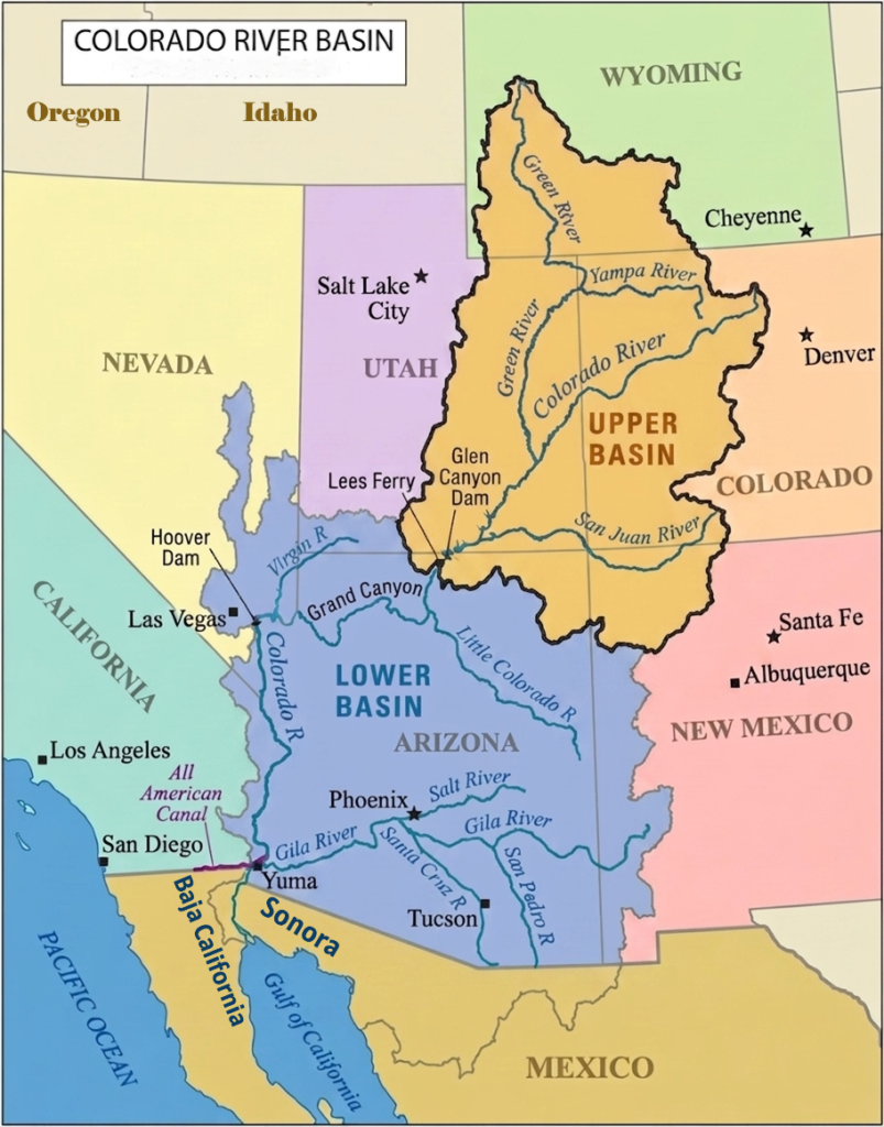
The Colorado River Basin is the vast drainage region fed by the Colorado River and its tributaries across the American Southwest and northwestern Mexico. Covering approximately 246,000 square miles, the basin stretches across seven U.S. states—Colorado, Wyoming, Utah, New Mexico, Arizona, Nevada, and California—along with the Mexican states of Baja California and Sonora.
The basin includes some of the most diverse landscapes in North America, ranging from the snow-covered Rocky Mountains to deep canyons, plateaus, deserts, and arid valleys. Water from the basin originates mainly as snowpack in the Rocky Mountains, especially in Colorado and Wyoming. Seasonal snowmelt feeds the river system and supplies water to millions of people downstream.
The basin is officially divided at Lees Ferry in northern Arizona into the Upper Basin and Lower Basin. The Upper Basin supplies most of the river’s natural water through Rocky Mountain snowpack, while the Lower Basin consumes the majority of the river’s water for agriculture and urban use.
Colorado River Upper Basin
The Upper Basin includes Wyoming, Colorado, Utah, and New Mexico. This region contains the headwaters of the Colorado River and receives most of its water from snowpack in the Rocky Mountains. Major tributaries in the Upper Basin include the Green River, Gunnison River, and San Juan River.
The landscape of the Upper Basin includes alpine mountains, forests, plateaus, and deep canyon systems. Important reservoirs such as Lake Powell store water for downstream states and generate hydroelectric power. Although the Upper Basin has a smaller population than the Lower Basin, it plays a critical role because it supplies most of the river’s total flow.
Colorado River Lower Basin
The Lower Basin includes Arizona, California, and Nevada. In this section, the Colorado River flows through arid desert regions where water demand is extremely high. Major reservoirs such as Lake Mead, formed by Hoover Dam, are essential for water storage, hydroelectric power, and flood control.
The Lower Basin supports large metropolitan areas including Phoenix, Las Vegas, and parts of Southern California. Massive irrigation systems also divert river water to agricultural regions such as California’s Imperial Valley. Because of its large cities and extensive farmland, the Lower Basin consumes most of the Colorado River’s allocated water supply.
Tributaries of Colorado River
The Colorado River receives water from numerous tributaries that flow from the Rocky Mountains, desert plateaus, and canyon regions of the American Southwest. These tributaries are essential to the river system, supplying snowmelt, runoff, and seasonal flow across the Colorado River Basin.
The tributaries are commonly classified as left bank and right bank tributaries based on the direction from which they join the main river downstream.
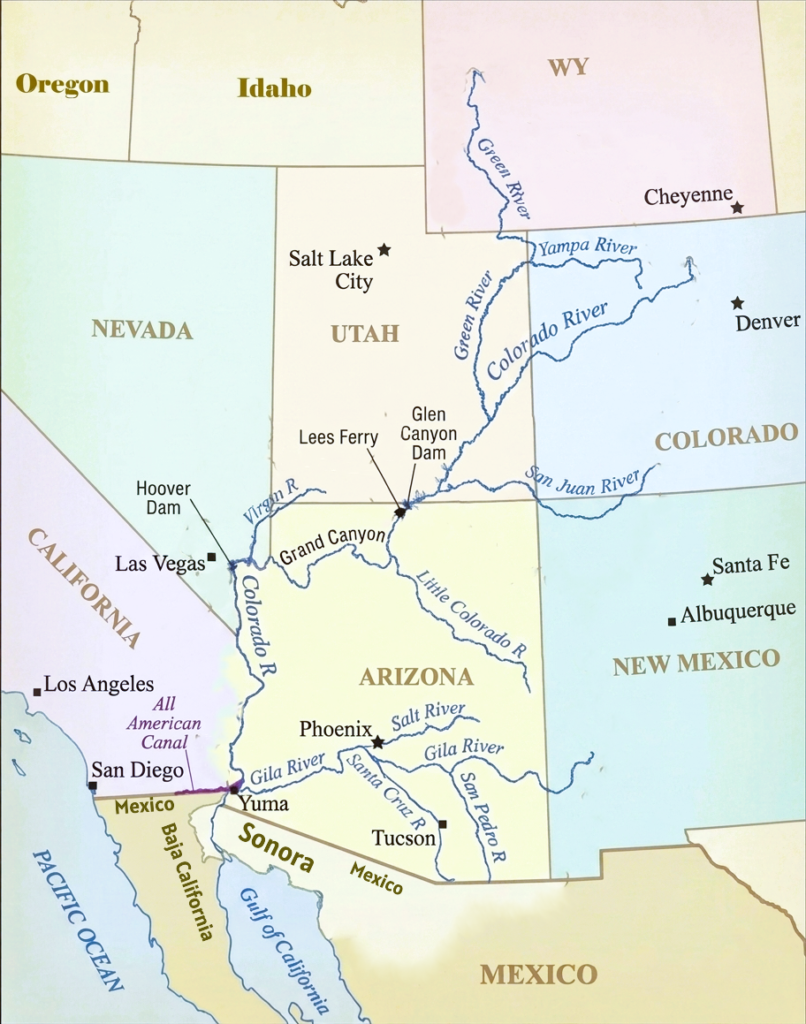
Left Bank Tributaries of Colorado River
The left bank tributaries of the Colorado River generally enter the river from the eastern and southern sides as it flows southwest across the American Southwest. These tributaries play an important role in supplying snowmelt, sediment, and seasonal runoff to the Colorado River system while helping carve many of the deep canyon landscapes found throughout the basin.
Major left bank tributaries include the Fraser River, Blue River, Eagle River, Roaring Fork River, Gunnison River, Dolores River, San Juan River, Little Colorado River, Bill Williams River, and Gila River.
Gunnison River
The Gunnison River is a 180-mile-long tributary of the Colorado River located in western Colorado. Formed by the confluence of the Taylor and East rivers, it flows generally east to west through dramatic landscapes, including the Black Canyon of the Gunnison National Park, before joining the Colorado River in Grand Junction.
Dolores River
The Dolores River is a 241-mile-long tributary of the Colorado River that flows through the rugged, arid landscapes of southwestern Colorado and southeastern Utah. Rising in the high San Juan and La Plata Mountains, Colorado at nearly 12,000 feet, the river carves through stunning red rock sandstone formations and deep wilderness canyons before reaching its confluence near Moab, Utah.
San Juan River
The San Juan River is a 355-mile-long tributary of the Colorado River, originating in Colorado’s San Juan Mountains. It flows through Colorado, New Mexico, and Utah before entering the Colorado River system near Lake Powell. It is one of the largest tributaries in the upper basin and supplies water to the Four Corners region.
The river is known for its desert canyons and archaeological sites. It is famous for world-class trout fishing in New Mexico and rugged whitewater rafting and deep, entrenched meanders in Utah.
Little Colorado River
The Little Colorado River, 315-mile-long, joins the Colorado River within the Grand Canyon in northern Arizona. Although smaller than many upper basin tributaries, it plays an important ecological role and is known for its distinctive blue-green water and canyon scenery. It drains a vast area of the Painted Desert, carrying immense cultural significance for Southwestern Indigenous tribes.
Bill Williams River
The Bill Williams River is a 46.3-mile-long perennial tributary of the Colorado River located in western Arizona. Formed by the confluence of the Big Sandy and Santa Maria rivers at Alamo, it flows westward through the Sonoran Desert before emptying into the Colorado River near Lake Havasu just north of Parker, Arizona. The river drains a watershed of about 5,200 square miles and supports important riparian habitats and desert ecosystems in an otherwise arid region.
Gila River
The Gila River is a 649-mile-long final major left bank tributary of the Colorado River that flows from southwestern New Mexico through southern Arizona before joining the Colorado River at Yuma, Arizona. Originating in the Mogollon and Black Range mountains of Gila National Forest, the river flows westward across Arizona, passing through Safford and south of Phoenix. It drains an arid watershed of about 58,100 square miles extending across Arizona, New Mexico, and northern Sonora in Mexico, and plays an important role in regional agriculture, Indigenous communities, and desert ecosystems.
Right Bank Tributaries of Colorado River
The right bank tributaries of the Colorado River generally join the river from the western and northern sides as it flows southwest across the Colorado Plateau and desert Southwest. Together with the left bank tributaries, these rivers have carved a complex network of deep canyons, mesas, and desert valleys throughout the upper and middle Colorado River Basin.
Green River
The Green River is a 730-mile-long largest and most important right bank tributary of the Colorado River. It originates in Wyoming’s Wind River Range and flows through Wyoming, Colorado, and Utah before joining the Colorado River in Canyonlands National Park. The Green River drains a massive watershed and contributes a large portion of the Colorado River’s total flow.
Dirty Devil River
The Dirty Devil River (80-mile-long) flows through remote canyon country in Utah before entering the Colorado River system. It drains arid desert landscapes and is known for its extreme isolation, heavily silted waters, and stunning canyon geology.
Escalante River
The Escalante River is an 80–90-mile-long tributary of the Colorado River located in south-central Utah. It is formed by the confluence of Upper Valley and Birch creeks near the town of Escalante, Utah. The river flows through deep labyrinthine canyons, massive Navajo sandstone cliffs, and riparian oases across the Colorado Plateau. It empties into Lake Powell within the Glen Canyon National Recreation Area.
Paria River
The Paria River is a 95-mile-long tributary of the Colorado River flowing through southern Utah and northern Arizona. Originating near Tropic, Utah within the Grand Staircase–Escalante National Monument, the river cuts through soft sandstone of the Colorado Plateau, forming dramatic narrow slot canyons famous for wilderness backpacking, canyoneering, and landscape photography.
It joins the Colorado River at Lees Ferry, Arizona, the traditional starting point for Grand Canyon river expeditions. Lees Ferry also marks the official division between the Upper Basin and Lower Basin of the Colorado River system.
Kanab Creek
Kanab Creek is a 125-mile stream that serves as the largest tributary canyon system on the north side of the Grand Canyon. Originating on the Paunsaugunt Plateau in Kane County, Utah, it cuts south through sandstone cliffs and arid plateaus before emptying directly into the Colorado River inside Grand Canyon National Park.
Virgin River
The Virgin River flows through Utah, Arizona, and Nevada before joining the Colorado River near the Nevada-Arizona border. The river is known for carving Zion Canyon in Zion National Park and serves as an important water source in the lower basin.
Hardy River
The Hardy River is a 16-mile-long river that forms part of the lower river system in Mexico. It is connected to the Colorado River Delta region and represents one of the final waterways associated with the Colorado River before reaching the Gulf of California.
Frequently Asked Questions About Colorado River
Where does the Colorado River begin and end?
The Colorado River begins at La Poudre Pass Lake in Rocky Mountain National Park, Colorado, and historically ends in the Gulf of California in Mexico.
What is the main source of water for the Colorado River?
The river is mainly fed by snowmelt from the Rocky Mountains.
What states does the Colorado River run through?
The Colorado River flows through Colorado, Utah, Arizona, Nevada, California, and into Mexico.
How many states share the Colorado River Basin?
Seven U.S. states share the basin: Colorado, Wyoming, Utah, New Mexico, Arizona, Nevada, and California.
Does the Colorado River run through Texas?
No. The Southwestern Colorado River does not flow through Texas. Texas has a separate river also named the Colorado River.
Are there two Colorado rivers in the USA?
Yes. One is the famous Colorado River of the American Southwest, and the other is the Colorado River in Texas.
How was the Colorado River formed?
The river formed over millions of years through erosion and tectonic uplift, carving deep canyons such as the Grand Canyon.
Which river carved the Grand Canyon?
The Colorado River carved the Grand Canyon over millions of years.
What was the Colorado River originally called?
The upper section of the river was historically known as the “Grand River.”
How long is the Colorado River?
The Colorado River is approximately 1,450 miles (2,330 kilometers) long.
How deep is the Colorado River?
The river’s depth varies greatly, ranging from a few feet to over 100 feet near reservoirs and dams.
How cold is Colorado River water?
Water temperatures vary by location, but below major dams the water is often around 45–55°F (7–13°C).
Is the Colorado River drying up?
Yes. Long-term drought, climate change, and overuse have significantly reduced river flow and reservoir levels.
Does the Colorado River reach the ocean?
Historically yes, but today the river often does not fully reach the ocean because of water diversions and dams.
Are there alligators in the Colorado River?
No. Alligators are not native to the Colorado River.
Can you swim in the Colorado River?
Yes, swimming is allowed in many areas, but strong currents and cold water can make some sections dangerous.
Why is the Colorado River important?
The river supplies water to nearly 40 million people and supports agriculture, hydropower, cities, wildlife, and tourism across the American Southwest.
Why is the Colorado River so famous?
The river is famous for carving the Grand Canyon and for its major dams, reservoirs, rafting, and importance to the western United States.