Often called “The River of the West,”, the Columbia River flows approximately 1,243 miles from its source in British Columbia, Canada, to the Pacific Ocean near the border between Oregon and Washington. Its drainage basin covers around 258,000 square miles, making it one of the largest river systems in North America. The river drains portions of seven U.S. states and one Canadian province, creating an enormous interconnected watershed. It is a massive driver of hydroelectricity, agriculture, and Native American culture, while its scenic Gorge offers popular river cruising and tourism.
Table of Contents
Origin of the Columbia River
The Columbia River originates at Columbia Lake in the Rocky Mountain Trench of southeastern British Columbia, Canada. The lake lies at an elevation of approximately 2,690 feet above sea level and marks the beginning of the river’s 1,243-mile journey to the Pacific Ocean near Astoria.
The headwaters of the Columbia River begin in a mountainous and glacier-influenced region of the Canadian Rockies. Columbia Lake itself is a calm, narrow lake about 8 miles long, fed by surrounding streams, wetlands, snowmelt, and glacier runoff. These waters gradually gather to form the main channel of the Columbia River.
The river’s water system is closely connected to the Columbia Icefield in the Canadian Rockies. Meltwater from glaciers and alpine snowfields moves through interconnected wetlands and mountain streams before reaching Columbia Lake. This glacier-fed origin helps provide the river with a strong and consistent flow throughout much of the year.
One of the most unusual features of the Columbia River’s origin is its initial direction of flow. Instead of immediately heading south or west toward the Pacific Ocean, the river first flows north for nearly 200 miles through the Rocky Mountain Trench. Near Revelstoke, British Columbia, the river makes a major bend and turns southward, eventually crossing the Canada–United States border into Washington State.
Course of the Columbia River
The Columbia River flows approximately 1,243 miles from Columbia Lake in British Columbia, Canada, to the Pacific Ocean near Astoria. Its course passes through the Rocky Mountains, the Columbia Plateau, the Cascade Range, and coastal lowlands, making it one of the most geographically diverse rivers in North America.
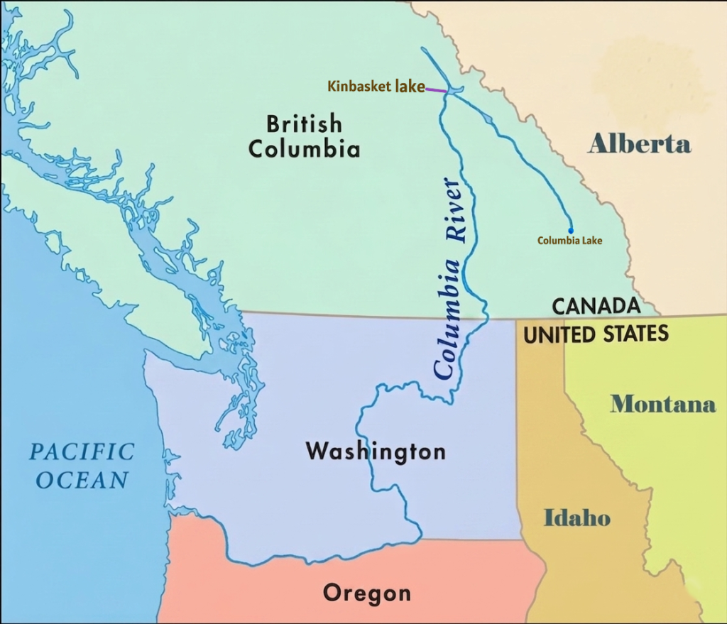
Headwaters and Upper Course (British Columbia, Canada)
The Columbia River begins at Columbia Lake in the Rocky Mountain Trench of southeastern British Columbia. The headwaters are fed by glacier melt, snowmelt, wetlands, and mountain streams originating in the Canadian Rockies. Columbia Lake itself is a narrow freshwater lake located at an elevation of about 2,690 feet above sea level.
One of the river’s most unusual characteristics is its initial direction of flow. Instead of immediately flowing south toward the Pacific Ocean, the Columbia first travels northwest for nearly 190 miles through forested mountain valleys within the Rocky Mountain Trench. Near Revelstoke, British Columbia, the river makes a dramatic bend and turns southward for roughly 270 miles toward the Canada–United States border.
During this upper course, the river flows through rugged mountain terrain, deep valleys, and the dramatic Rocky Mountain Trench before entering several large reservoirs created by hydroelectric dams. Major reservoirs in this section include Kinbasket Lake, formed by Mica Dam; Lake Revelstoke, created by Revelstoke Dam; and the Arrow Lakes reservoir system, expanded by the Hugh Keenleyside Dam.
The region is heavily influenced by Rocky Mountain snowpack, glacier melt, and alpine runoff, which provide a continuous high-volume water supply and help maintain the river’s strong flow throughout the year.
The Big Bend and Central Washington
After crossing into northeastern Washington, the Columbia River enters one of the most distinctive sections of its course known as the “Big Bend.” In this region, the river sweeps south and west through central Washington in a massive geological arc.
The river flows across the Columbia Plateau, a broad volcanic region formed by ancient basalt lava flows. Over thousands of years, Ice Age floods carved dramatic landscapes throughout this area, including steep canyons, dry coulees, and layered basalt cliffs. One of the most famous landforms here is the Grand Coulee, a massive dry canyon created by prehistoric floodwaters.
This section of the river is also heavily developed for hydroelectric power and irrigation. Major dams such as Grand Coulee Dam and Chief Joseph Dam are located along the river in central Washington. Near Pasco, Washington, the Columbia receives its largest tributary, the Snake River, which significantly increases the river’s water volume and drainage area.
Columbia River Gorge and Border Region
Below the Snake River confluence, the Columbia River turns westward and begins forming much of the border between Washington and Oregon. This section contains the famous Columbia River Gorge, one of the most scenic and geologically significant river valleys in North America.
The gorge cuts directly through the Cascade Mountain Range and stretches for more than 80 miles between eastern Oregon and the Portland metropolitan region. Steep cliffs, waterfalls, volcanic rock formations, and dense forests dominate the landscape. The gorge also serves as a natural transportation corridor linking the Pacific coast with the interior Pacific Northwest.
Strong winds funneled through the gorge make this region internationally known for windsurfing and kiteboarding. Several major hydroelectric dams, including Bonneville Dam and The Dalles Dam, are also located along this stretch of the river.
Lower Columbia River and Mouth
After leaving the Columbia River Gorge, the river enters broader lowland regions near Portland and Vancouver. In this lower course, the river becomes wider and slower as it approaches the Pacific coast.
Near Vancouver, Washington, the Columbia briefly turns north before curving west again for its final stretch to the ocean. The river eventually empties into the Pacific Ocean at Astoria, Oregon, forming a large estuary where freshwater mixes with seawater.
Columbia River Estuary
The Columbia River Estuary is the large tidal mixing zone where the Columbia River meets the Pacific Ocean along the border of Oregon and Washington. Stretching approximately 146 miles inland from the Pacific Ocean to Bonneville Dam, the estuary is one of the most productive and ecologically important estuarine systems on the Pacific coast of North America.
Unlike a traditional sediment-built delta, the Columbia River forms a broad estuary where freshwater from the river mixes with saltwater from the Pacific Ocean. This interaction between river flow, ocean tides, and coastal currents creates a nutrient-rich environment that supports wetlands, fisheries, migratory birds, and diverse aquatic ecosystems throughout the lower Columbia Basin.
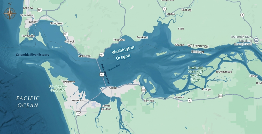
The estuary extends inland from the Pacific coast near Astoria and Cape Disappointment, Washington. It includes a complex network of tidal channels, marshes, swamps, sloughs, intertidal mudflats, and shallow bays. Constant tidal movement and changing salinity levels shape the estuary’s landscape and ecological conditions. These wetlands and tidal habitats also help absorb floodwaters, reduce erosion, filter pollutants, and improve water quality throughout the lower river system.
The Columbia River Estuary is internationally recognized for its ecological productivity and biodiversity. Nutrients carried downstream by the Columbia River combine with ocean nutrients from the Pacific to create rich feeding grounds for fish, birds, shellfish, and marine species. The estuary serves as a critical transition zone for juvenile salmon and steelhead migrating from inland rivers to the Pacific Ocean. Species such as Chinook salmon, Coho salmon, and steelhead trout rely on the estuary to gradually adapt from freshwater to saltwater before beginning their ocean migration.
The estuary also supports sturgeon, lamprey, crabs, shellfish, and numerous smaller fish species. Wetlands and tidal marshes act as nursery habitats for aquatic life, making the estuary essential to both freshwater and marine ecosystems across the Pacific Northwest.
The Columbia River Estuary is one of the most important bird habitats along the Pacific Flyway, the major migratory route used by birds traveling along the western coast of North America. Hundreds of thousands of shorebirds, ducks, geese, swans, and other migratory birds stop in the estuary during seasonal migrations. The region’s mudflats, wetlands, and marshes provide critical feeding and resting areas during these long journeys.
Because of its importance to migratory bird populations, parts of the lower estuary are recognized within the Western Hemisphere Shorebird Reserve Network. During spring migration especially, massive numbers of shorebirds gather in the estuary to feed on nutrient-rich tidal flats before continuing northward.
Large portions of the estuary are protected through wildlife refuges and conservation programs. The Lewis and Clark National Wildlife Refuge protects islands, tidal marshes, and swamps that provide habitat for migratory birds and aquatic species. Another important protected area is the Julia Butler Hansen National Wildlife Refuge, which contains more than 6,000 acres of tidal marsh and wetland habitat and serves as an important sanctuary for the endangered Columbian white-tailed deer.
Despite its ecological importance, the Columbia River Estuary faces several environmental challenges. Pollution from industrial, agricultural, and urban sources upstream affects water quality throughout the estuary. Wetland drainage, habitat conversion, dredging activities, and shoreline development have reduced natural habitats over time. Juvenile salmon populations are also threatened by habitat loss, altered river flows, and increased predation.
The Columbia River Estuary also supports regional economies through fishing, shipping, recreation, and tourism. Ports along the lower Columbia River serve as important trade centers connecting inland Pacific Northwest agriculture and industries with international markets. Recreational fishing, birdwatching, wildlife tourism, and boating are also major economic activities linked to the estuary.
The mouth of the Columbia River is also well known for dangerous navigation conditions. Strong river currents collide with Pacific Ocean waves, creating shifting sandbars and turbulent waters. This area became known as the “Graveyard of the Pacific” because of the large number of shipwrecks that occurred there historically.
Today, the Columbia River Estuary remains one of the most valuable natural environments in the Pacific Northwest. Its wetlands, fisheries, bird habitats, and tidal ecosystems play a critical role in connecting the Columbia River Basin with the Pacific Ocean while supporting both biodiversity and human activity along the Pacific coast.
Columbia River Basin
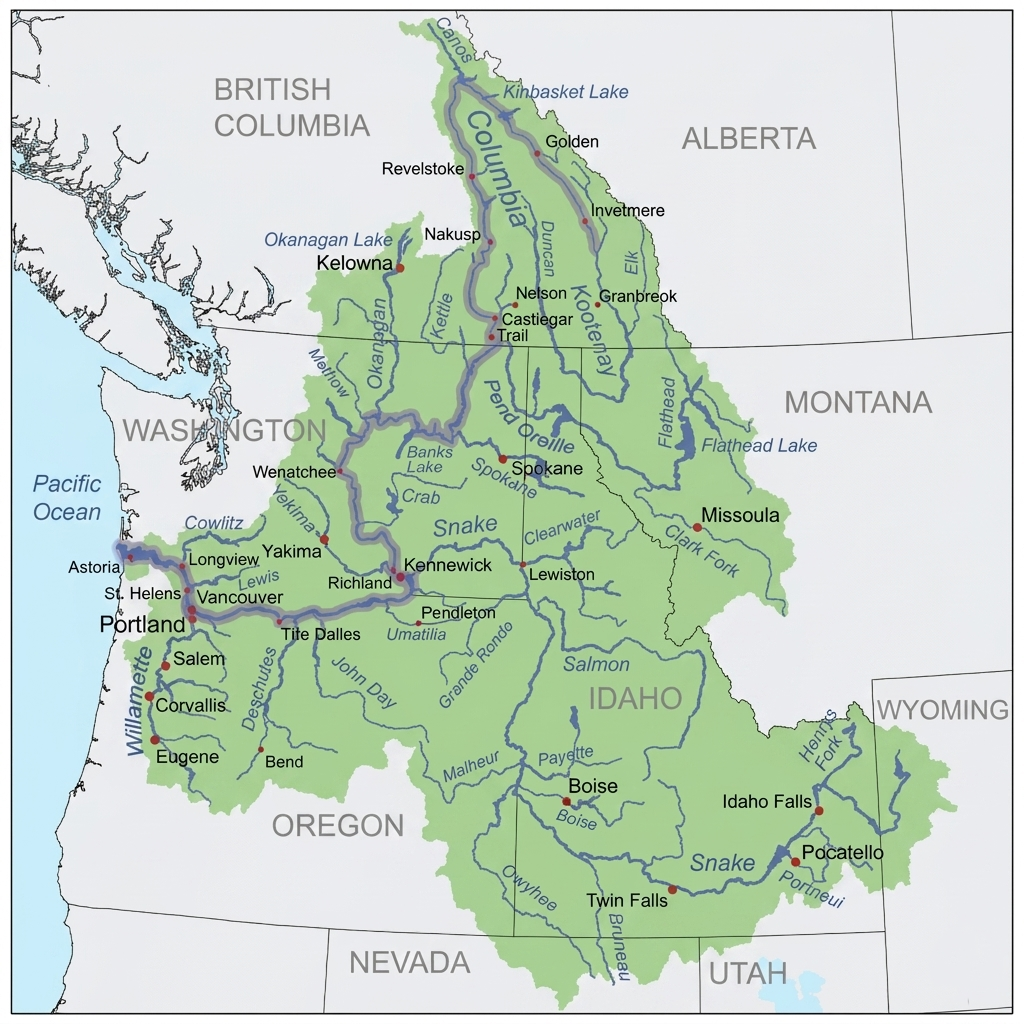
The Columbia River Basin is one of the largest river drainage systems in North America, covering approximately 258,000 square miles across the northwestern United States and western Canada. The basin includes the entire network of the Columbia River and its tributaries, stretching across British Columbia, Canada and seven U.S. states (Washington, Oregon, Idaho, Montana, Wyoming, Nevada, and Utah).
Upper Columbia River Basin
The Upper Columbia River Basin begins in the Rocky Mountains of southeastern British Columbia and extends into northeastern Washington. This region is characterized by rugged mountain landscapes, glacier-fed rivers, deep valleys, forests, and large lakes and reservoirs. Snowpack and glacier melt from the Canadian Rockies provide much of the water supply for the upper basin.
Major tributaries in this section include the Kootenay River, Pend Oreille River, and Spokane River. Large reservoirs and lakes dominate parts of the landscape, including Lake Roosevelt, which was formed behind Grand Coulee Dam.
The upper basin contains several important hydroelectric projects. Grand Coulee Dam is the largest hydropower producer in the United States and plays a major role in electricity generation, irrigation, and flood control throughout the Pacific Northwest. Other major dams include Chief Joseph Dam and multiple Canadian hydroelectric dams operated under the Columbia River Treaty between the United States and Canada.
Ecologically, the Upper Columbia Basin has become a major focus for salmon and steelhead restoration efforts. Historically, salmon migrated far upstream into Canada before dam construction blocked access to many spawning grounds. Modern restoration projects aim to improve fish habitats and support reintroduction programs above Grand Coulee Dam.
Middle Columbia River Basin
The Middle Columbia River Basin extends across central and eastern Washington and northern Oregon, covering much of the Columbia Plateau region. This area is dominated by semi-arid and arid landscapes shaped by ancient volcanic activity and Ice Age floods.
The basin in this region supports extensive agricultural development through irrigation systems supplied by the Columbia River and its tributaries. Large farming operations produce crops such as wheat, apples, potatoes, hops, and grapes across the plateau region.
Major tributaries in the middle basin include the Yakima River and the Snake River, the largest tributary of the Columbia River system. The confluence of the Snake and Columbia rivers near Pasco, Washington, is one of the most important fish migration corridors in the Pacific Northwest.
The middle basin also contains numerous hydroelectric dams including Priest Rapids Dam, Wanapum Dam, Rock Island Dam, Rocky Reach Dam, Wells Dam, McNary Dam, John Day Dam, and The Dalles Dam. These projects generate electricity, support navigation, and regulate river flow throughout the region.
Ecologically, this section of the basin contains critical spawning habitats and migratory channels for salmon and steelhead. Fish ladders and bypass systems have been constructed at major dams to support the movement of anadromous fish through the river system.
Lower Columbia River Basin
The Lower Columbia River Basin begins near the Columbia River Gorge and extends westward to the Pacific Ocean. This region includes the Cascade Mountains, coastal lowlands, wetlands, and the estuarine environments of the lower Columbia River.
One of the defining features of the lower basin is the Columbia River Gorge, where the river cuts through the Cascade Range between Washington and Oregon. Farther downstream, ocean tides influence the river system for up to 140 miles inland, creating complex estuarine conditions.
Major tributaries in the lower basin include the Cowlitz River, Lewis River, and Willamette River. The Willamette River joins the Columbia near Portland, significantly increasing water flow in the lower river system.
The major hydroelectric structure in this region is Bonneville Dam, the final dam on the Columbia River before it reaches the Pacific Ocean. Bonneville Dam plays an important role in hydropower generation, navigation, and fish passage management.
The Lower Columbia Basin is economically and ecologically important because it supports deep-water shipping corridors, major ports, fisheries, wetlands, and estuarine ecosystems. Important port cities include Portland, Oregon, and Vancouver.
This lower stretch of the river also forms the final migration route for salmon returning from the Pacific Ocean to inland spawning grounds. Wetlands and estuarine habitats throughout the basin provide critical nursery and feeding areas for fish, birds, and coastal wildlife.
Tributaries of the Columbia River
The Columbia River is supported by one of the largest and most complex tributary systems in North America. Hundreds of rivers and streams feed the Columbia throughout its 1,243-mile course from the Canadian Rockies to the Pacific Ocean. These tributaries supply water from glaciers, snowfields, forests, volcanic plateaus, wetlands, and mountain ranges across the Pacific Northwest.
The tributary network of the Columbia River stretches across British Columbia and seven U.S. states, forming the vast Columbia River Basin. Many of these tributaries are themselves major river systems with important ecological, economic, and historical significance. They provide irrigation water, hydroelectric power, fish habitat, transportation routes, and freshwater ecosystems throughout the region.
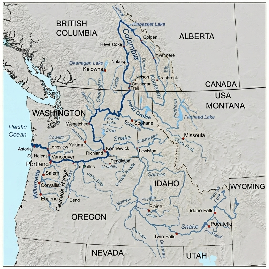
Tributaries of Columbia River in Canada
The Canadian portion of the Columbia River lies entirely within British Columbia and originates in the Rocky Mountain Trench. Major tributaries feeding the mainstem in Canada include the Kootenay, Pend Oreille, and Canoe rivers, alongside several glacial-fed tributaries from the surrounding mountain ranges.
Kootenay River
The Kootenay River (called Kootenai in the United States) is a 781-km tributary of the Columbia River. It begins in the Canadian Rockies of British Columbia, flows through Montana and Idaho, then returns to British Columbia before joining the Columbia River at Castlegar. The river passes through Kootenay Lake and the traditional territory of the Ktunaxa people. It is known for fishing, kayaking, wildlife, and scenic spots like Kootenai Falls.
Pend Oreille River
The Pend Oreille River is a 130-mile tributary of the Columbia River that flows from northern Idaho through Washington into British Columbia. It begins at Lake Pend Oreille and joins the Columbia River in southeastern British Columbia, where it is called the Pend-d’Oreille River. Hydroelectric development plays a major role along the river, with important dams including Albeni Falls Dam, Box Canyon Dam, Boundary Dam, Seven Mile Dam, and Waneta Dam.
Canoe River
The Canoe River is the northernmost tributary of the Columbia River in British Columbia. It flows south to join the Columbia at the famous “Big Bend,” where the river turns sharply southward. The lower section of the Canoe River was flooded by the Mica Dam project, creating the Canoe Reach of Kinbasket Lake.
Blaeberry River
The Blaeberry River is a 37-mile glacier-fed tributary of the Columbia River in the Canadian Rockies of British Columbia. It flows south from Howse Pass and joins the Columbia River near the mountain town of Golden.
Kicking Horse River
The Kicking Horse River is a scenic tributary of the Columbia River in southeastern British Columbia. Rising in Yoho National Park, the river is famous for its turquoise glacial waters and exciting Class II to IV whitewater rapids. It flows west through the town of Golden before joining the Columbia River. The Kicking Horse River is one of the top rafting destinations in the Canadian Rockies. The Upper Canyon offers calmer rapids for beginners, while the Middle and Lower Canyons feature powerful Class III and IV rapids popular with experienced rafters.
Spillimacheen River
The Spillimacheen River is a 73-mile tributary of the Columbia River in British Columbia. Rising near Glacier National Park, it flows through the Selkirk Mountains before joining the Columbia River near the community of Spillimacheen. Known for its steep mountain terrain and clear waters, the river is popular for fishing and advanced whitewater kayaking. The famous “Canyon Run” features demanding Class IV rapids and technical drops for experienced paddlers. The river is also used for hydropower through the Spillimacheen Dam.
Beaver River
The Beaver River is a tributary of the Columbia River in British Columbia. Flowing through the Selkirk Mountains, it enters the Columbia River system through Kinbasket Lake in the Rocky Mountain Trench northwest of Golden. The river is also known historically as Beavermouth Creek or Beaver Creek.
Illecillewaet River
The Illecillewaet River is a 39-mile tributary of the Columbia River in British Columbia. Rising from the Illecillewaet Glacier in Glacier National Park, it flows southwest through rugged mountain terrain before emptying into Upper Arrow Lake at the city of Revelstoke. Known for its fast-flowing glacial waters, the river is popular for Class III–IV whitewater rafting and kayaking. Because of heavy sediment and seasonal flooding risks, the river is actively managed with dikes and monitoring systems.
Incomappleux River
The Incomappleux River is a 42-mile tributary of the Columbia River in southeastern British Columbia. Rising in the Selkirk Mountains, it flows south into the Beaton Arm of Upper Arrow Lake near Revelstoke. The river valley is famous for its rare inland temperate rainforest, home to ancient cedar and hemlock forests, grizzly bears, bull trout, and diverse wildlife.
Tributaries of Columbia River in United States
The Columbia River has over 60 significant tributaries in the United States, spanning across the Pacific Northwest. Its largest and most significant tributaries—including the Snake, Willamette, and Cowlitz rivers—drain major portions of Idaho, Montana, Wyoming, Oregon, and Washington.
Snake River
The Snake River is a 1,078-mile tributary of the Columbia River and the largest river in its watershed. It begins in Yellowstone National Park and flows through Wyoming, Idaho, Oregon, and Washington before joining the Columbia River near the Tri-Cities area of Washington. The river is famous for landmarks such as Hells Canyon, the deepest river gorge in North America, and Shoshone Falls, often called the “Niagara of the West.” The Snake River Plain forms a major agricultural region in southern Idaho.
Spokane River
The Spokane River is a 111-mile tributary of the Columbia River that flows from northern Idaho into eastern Washington. Beginning at Lake Coeur d’Alene, the river passes through the city of Spokane, where the famous Spokane Falls are located, before emptying into Lake Roosevelt (Columbia River). Major tributaries include the Little Spokane River and Hangman Creek. For thousands of years, the Spokane River has held deep cultural importance for the Spokane Tribe of Indians and other Indigenous peoples of the Columbia Plateau.
Walla Walla River
The Walla Walla River is a 61-mile tributary of the Columbia River that flows through northeastern Oregon and southeastern Washington. Rising in the Blue Mountains, the river flows north through Milton-Freewater and Walla Walla County before joining the Columbia River near Wallula.
John Day River
The John Day River is a 284-mile tributary of the Columbia River and the longest free-flowing undammed river west of the Rocky Mountains in the contiguous United States. Rising in the Blue Mountains, it flows through northeastern and central Oregon before joining the Columbia River. The river is known for its rugged high-desert canyons, basalt cliffs, grasslands, and fossil-rich landscapes near the John Day Fossil Beds National Monument. It provides critical habitat for wild summer steelhead and spring Chinook salmon.
Deschutes River
The Deschutes River is a 252-mile tributary of the Columbia River in central Oregon. Rising at Little Lava Lake in the Cascade Range, it flows north through Bend before joining the Columbia River near The Dalles. Known as the “Peculiar River” for its steady year-round flow, the river passes through mountain forests, volcanic landscapes, and scenic high-desert canyons.
Willamette River
The Willamette River is a 187-mile tributary of the Columbia River that flows north through western Oregon. Rising in the Cascade Mountains, it passes through major cities including Eugene, Salem, and Portland before joining the Columbia River north of Portland. The river forms the backbone of the fertile Willamette Valley, home to most of Oregon’s population and famous wine-growing regions.
Kettle River
The Kettle River is a 175-mile undammed tributary of the Columbia River. Rising at Holmes Lake in the Monashee Mountains, it flows through southern British Columbia and northeastern Washington, crossing the Canada–U.S. border multiple times before joining Lake Roosevelt near Kettle Falls.
Sanpoil River
The Sanpoil River is a 70-mile tributary of the Columbia River in northeastern Washington. Flowing south from the town of Republic, the river passes through the Colville Indian Reservation before entering Lake Roosevelt near Keller Ferry. Named after the Sanpoil people, an Interior Salish tribe, the river remains culturally important to the Confederated Tribes of the Colville Reservation, which help manage and protect the watershed and wildlife habitat.
Okanogan River
The Okanogan River (called the Okanagan River in Canada) is a 115-mile tributary of the Columbia River. Rising from Okanagan Lake, it flows south through the Okanagan Valley and crosses into Washington before joining the Columbia River near Brewster. The river drains a semi-arid region east of the Cascade Range and passes communities including Kelowna, Oroville, Omak, and Okanogan. Its largest tributary is the Similkameen River.
Wenatchee River
The Wenatchee River is a 53-mile tributary of the Columbia River in central Washington. Beginning at Lake Wenatchee, the river flows southeast through the Cascade Mountains and joins the Columbia River near Wenatchee. Along its route, it passes communities such as Leavenworth, Cashmere, and Peshastin. Major tributaries include the Chiwawa River, Nason Creek, and Icicle Creek.
Yakima River
The Yakima River is a 214-mile tributary of the Columbia River in Washington. Rising in the Cascade Mountains, it flows southeast through the Yakima and Kittitas valleys before joining the Columbia River at Richland. One of its most scenic sections is the Yakima River Canyon, a dramatic basalt canyon between Ellensburg and Yakima known for rafting, kayaking, tubing, and wildlife viewing.
Lewis River
The Lewis River is a 95-mile tributary of the Columbia River in southwestern Washington. Rising on the western slopes of Mount Adams in the Cascade Mountains, the river flows west before joining the Columbia River. Its largest tributary, the East Fork Lewis River, is known for scenic swimming and hiking areas such as Moulton Falls Regional Park. The river is known for its scenic forests, waterfalls, and hydroelectric reservoirs, including Lake Merwin, Yale Lake, and Swift Reservoir. Outdoor recreation is especially popular near Cougar, where the Lewis River Trail leads to the scenic Lower Lewis River Falls, Middle Lewis River Falls, and Upper Lewis River Falls.
Cowlitz River
The Cowlitz River is a 105-mile tributary of the Columbia River in southwestern Washington. Rising in the Cascade Range near Mount Rainier and Mount Adams, the river flows through Lewis County before joining the Columbia River near Longview. Hydroelectric development has created major reservoirs along the river, including Lake Scanewa, Riffe Lake, and Mayfield Lake. Since the 1980 eruption of Mount St. Helens, the river system has faced major sediment and flooding challenges caused by volcanic debris carried by the Toutle River.
Frequently Asked Questions about Columbia River
Where is the Columbia River located?
The Columbia River is located in western North America, flowing through British Columbia in Canada and the U.S. states of Washington and Oregon before reaching the Pacific Ocean.
Where does the Columbia River start and end?
It starts at Columbia Lake in British Columbia, Canada, and ends at the Pacific Ocean near Astoria, Oregon, USA.
How long is the Columbia River?
The Columbia River is about 1,243 miles (2,000 km) long.
How deep is the Columbia River?
The Columbia River generally ranges from about 40 to over 100 feet in depth depending on location. In some natural channels it becomes deeper, and the Columbia River Gorge reaches depths of up to 4,000 feet.
How wide is the Columbia River?
The river starts as a narrow stream in Canada but expands downstream, reaching up to about 14 miles wide near its mouth at the Pacific Ocean around the Astoria–Megler Bridge.
Why is the Columbia River named that?
It was named after the American ship Columbia Rediviva, which explored the river in the 1790s.
Who discovered the Columbia River?
Captain Robert Gray was the first European to enter the river in 1792, although Indigenous peoples had lived along it for thousands of years.
Why do Americans say Columbia instead of Colombia?
“Columbia” is a historical and poetic reference to Christopher Columbus, while “Colombia” is the South American country with Spanish spelling.
Why is the Columbia River so famous?
It is famous for its salmon runs, hydroelectric dams, rich wildlife, and its major role in the history and economy of the Pacific Northwest.
Where is the Columbia River Gorge?
The Columbia River Gorge is a canyon along the border of Oregon and Washington where the river cuts through the Cascade Range.
How was the Columbia River Gorge formed?
It was formed by river erosion over millions of years and massive Ice Age floods that carved deep cliffs and valleys.
What to do in Columbia River Gorge?
Visitors can enjoy hiking, waterfalls, scenic viewpoints, photography, wildlife watching, and outdoor recreation.
Why is the mouth of the Columbia River so dangerous?
It is dangerous due to powerful river currents meeting Pacific Ocean waves, shifting sandbars, and unpredictable weather conditions known as the Columbia River Bar.
Are there sharks in the Columbia River?
No, sharks are not found in the Columbia River as it is freshwater, though marine animals like seals and sea lions may occasionally enter.
Can you swim in the Columbia River?
Yes, swimming is possible in some areas, but it can be dangerous due to strong currents, cold water, and boat traffic, so caution is strongly advised.