The Missouri River is the longest river in North America and one of the most historically significant waterways in the United States. Stretching approximately 2,341 to 2,540 miles, the river begins in the Rocky Mountains of southwestern Montana and eventually joins the Mississippi River near St. Louis, Missouri. Along its journey, it crosses vast plains, fertile farmland, rugged landscapes, growing cities, and important ecological regions that have shaped the development of the American West for centuries.
Often called the “Big Muddy” because of the large amount of sediment carried in its waters, the Missouri River has played a central role in exploration, trade, transportation, agriculture, and settlement throughout U.S. history. Native American tribes relied on the river long before European explorers arrived, and later expeditions such as the famous Lewis and Clark journey used the river as a gateway into the western frontier.
Today, the Missouri River remains an essential natural and economic resource. It supports irrigation systems, hydroelectric power generation, navigation, recreation, wildlife habitats, and regional tourism. At the same time, the river continues to face modern challenges related to flooding, environmental conservation, water management, and climate variability. Understanding the Missouri River means understanding a major part of the physical and cultural landscape of the United States.
Table of Contents
Origin of Missouri River
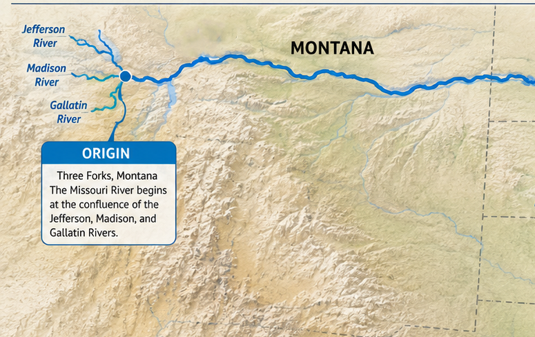
The Missouri River officially begins near Three Forks in southwestern Montana, where the Jefferson, Madison, and Gallatin rivers merge together. These headwaters originate in the snow-covered Rocky Mountains, where melting snow and mountain runoff feed the river system throughout the year. From this point, the Missouri River flows generally eastward and southward across the Great Plains before joining the Mississippi River.
Course of Missouri River
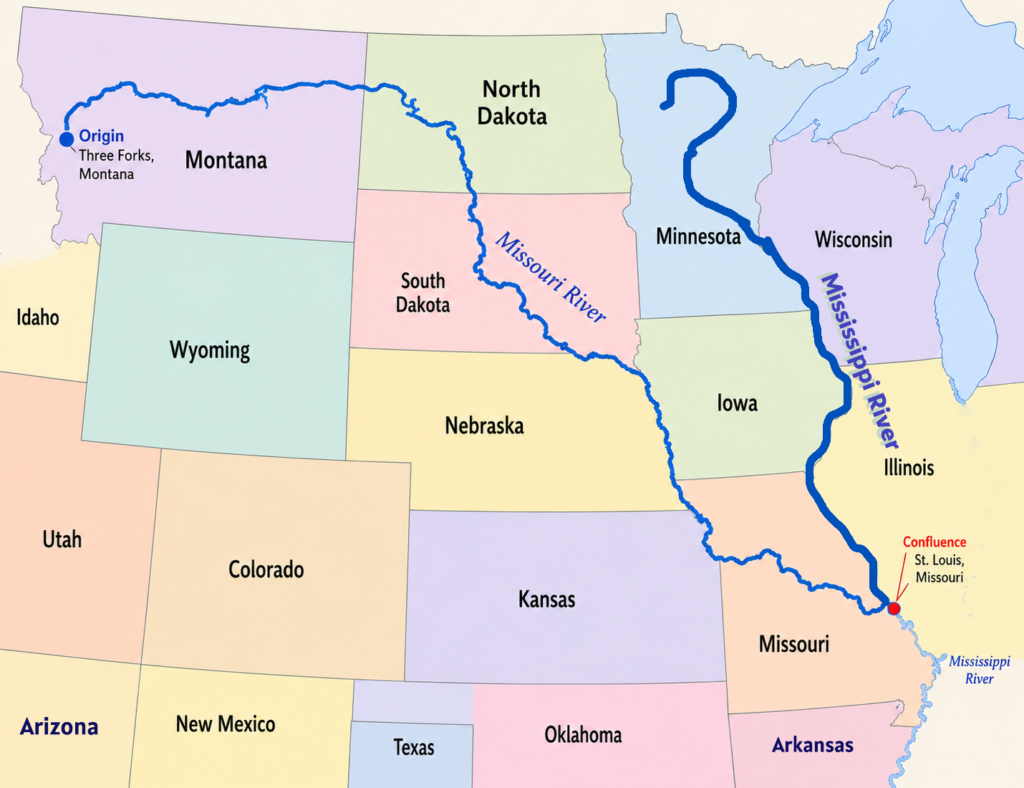
The Missouri River passes through or along the borders of 7 U.S. states: Montana, North Dakota, South Dakota, Nebraska, Iowa, Kansas, and Missouri. Along the way, it flows near major cities such as Bismarck, Pierre, Sioux City, Omaha, Kansas City, and St. Joseph. Its final confluence with the Mississippi River occurs just north of St. Louis, creating one of the largest river systems in the world.
Upper Missouri River Course
The Missouri River begins at Three Forks in southwestern Montana, where the Jefferson, Madison, and Gallatin rivers merge together. From its source, the river flows generally northward and eastward across Montana through valleys, grasslands, canyons, and rugged plains. In its upper course, the river is relatively narrow, cold, and fast-flowing because it is primarily fed by snowmelt from the Rocky Mountains.
This early stretch is also strengthened by several important Upper Basin tributaries, including the Gallatin, Jefferson, Madison, Sun, Milk, and Yellowstone rivers, all of which contribute varying amounts of mountain runoff, seasonal flow, and sediment to the developing river system.
One of the major locations along this section is Great Falls, Montana, where the river passes through a series of waterfalls and rapids that historically created an important obstacle for early explorers and traders. The surrounding Missouri Breaks region contains steep cliffs, badlands, and isolated landscapes that closely resemble the scenery encountered by the Lewis and Clark Expedition in the early 1800s.
Middle Missouri River Course
After leaving Montana, the Missouri River turns southeast and enters the Great Plains region of North Dakota and South Dakota. In North Dakota, the river flows near the city of Bismarck before continuing southward into South Dakota, where it passes near Pierre, the state capital. In this section, the river becomes much wider and slower because of broad plains and large reservoirs formed by major dams.
The Middle Basin is also strengthened by several important tributaries, including the Moreau, Cheyenne, White, Niobrara, James, and Platte rivers, which drain vast portions of the Great Plains and contribute seasonal runoff, sediment, and agricultural return flows into the main river system.
Several important reservoirs, including Lake Sakakawea and Lake Oahe, were created along the middle course for flood control, irrigation, navigation, and hydroelectric power generation. The surrounding plains support extensive farming and ranching activities, making the river an essential water source for agriculture across the region.
Lower Missouri River Course
Farther downstream, the Missouri River flows along portions of several state boundaries. It forms parts of the borders between South Dakota and Nebraska, Nebraska and Iowa, Nebraska and Missouri, and Kansas and Missouri. In this lower course, the river flows through fertile agricultural lands and heavily populated urban regions.
The Lower Basin is supported by important tributaries such as the Kansas, Osage, Grand, Nodaway, and Chariton rivers, which drain surrounding agricultural and rural areas before joining the main river system.
Major cities along this section include Sioux City, Omaha, Council Bluffs, Kansas City, and St. Joseph. The river in this region has been extensively modified with levees, navigation channels, and flood-control systems designed to reduce flooding and improve transportation. The lower Missouri River also carries large amounts of sediment, which contributed to its historic nickname, the “Big Muddy.”
Mouth of Missouri River
Near Kansas City, the Missouri River makes a major eastward turn and continues flowing across the state of Missouri. This final section passes through broad floodplains, industrial areas, and agricultural landscapes.
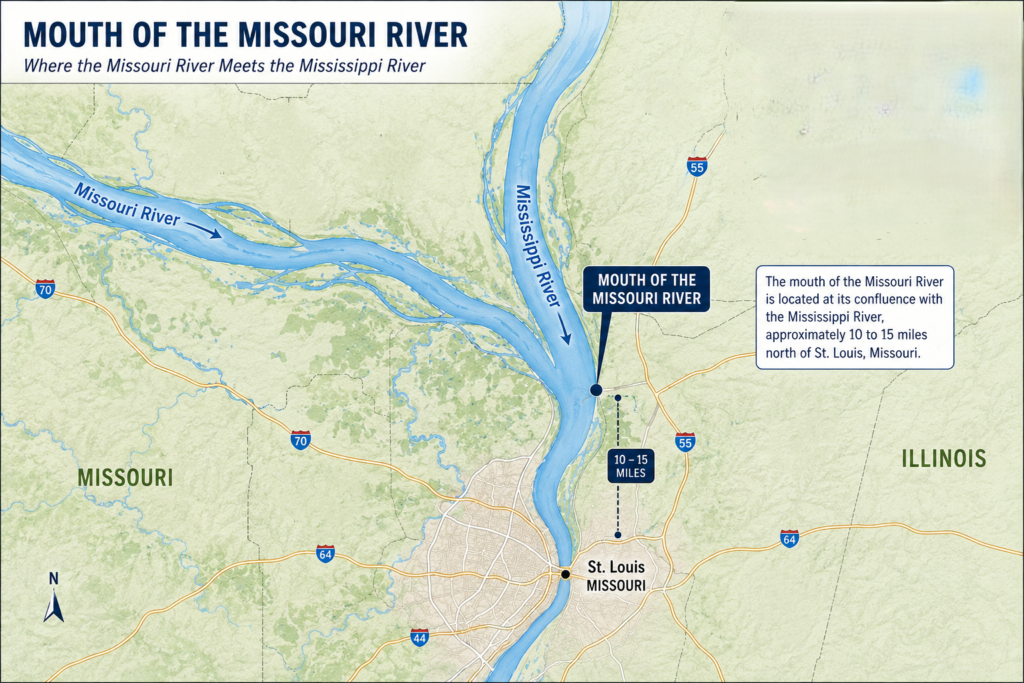
The mouth of the Missouri River is located at its confluence with the Mississippi River, approximately 10 to 15 miles north of St. Louis, Missouri. This important junction lies near the border of Missouri and Illinois, where the sediment-rich “Big Muddy” empties into the Mississippi River, forming one of the most significant river confluences in North America.
At the mouth, the Missouri River carries a large amount of silt and sediment from the Great Plains and Rocky Mountains, giving its water a lighter brown and muddy appearance. When it joins the Mississippi River, the difference in water color is often visible, creating a striking contrast where the two rivers mix together.
Hydrologically, this junction is extremely important because the Missouri River contributes nearly 45% of the total water flow of the Mississippi River past St. Louis, making it the Mississippi’s largest and longest tributary.
The mouth of the Missouri River has major economic and geographic importance because it links two of the largest river systems in the United States. This confluence supports inland navigation, freight transportation, agriculture, and regional commerce while also serving as an important ecological transition zone between the two rivers.
The meeting of the Missouri and Mississippi rivers forms one of the largest river systems in the world. This confluence has historically been important for trade, transportation, settlement, and economic development in the United States. From this point, the combined waters continue southward through the Mississippi River system toward the Gulf of Mexico.
Missouri River Basin
The Missouri River Basin is the largest river basin in the United States, covering more than 500,000 square miles. Stretching across a vast portion of central North America, the basin accounts for nearly one-sixth of the continental United States and forms one of the most extensive watershed systems on the continent.
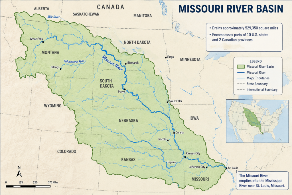
The basin includes mountain valleys, grasslands, prairie regions, agricultural plains, forests, wetlands, and humid lowlands. Thousands of rivers, streams, and tributaries feed into the Missouri River system, making it one of the most extensive watershed networks in the world. The basin plays a major role in agriculture, flood control, hydroelectric power generation, transportation, wildlife conservation, and water supply throughout the Great Plains and Midwest.
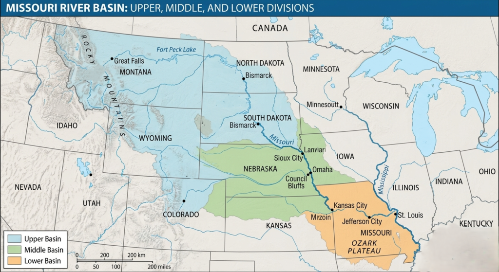
Upper Missouri River Basin
The Upper Missouri River Basin begins in southwestern Montana, where the Madison, Jefferson, and Gallatin rivers merge at Three Forks to form the Missouri River. From there, the river flows north and east through Montana before continuing into North Dakota. This region contains some of the most remote and rugged landscapes within the entire basin.
The upper basin is dominated by semi-arid environments, Rocky Mountain coniferous forests, open grasslands, and shrub-steppe ecosystems. Snowmelt from the mountains supplies much of the river’s water, especially during spring and early summer. The basin’s western terrain features valleys, rolling plains, badlands, and wide stretches of sparsely populated land.
Several major tributaries contribute to the upper basin, including the Yellowstone River and the Milk River. The Yellowstone River is especially important because it remains one of the longest undammed rivers in the continental United States and provides large volumes of water and sediment to the Missouri system. The Milk River extends into Canada and forms part of the basin’s northern drainage network.
Large federal reservoirs also define the upper basin. Fort Peck Lake in Montana and Lake Sakakawea in North Dakota are among the largest reservoirs in the Missouri River system. These reservoirs were created primarily for flood control, hydroelectric power generation, irrigation support, and water management. Their presence has dramatically changed the natural flow of the river while also providing recreation and water storage for downstream communities.
Hydrology in the upper basin is highly variable and sensitive to climate conditions. Between 2000 and 2010, much of the region experienced severe drought conditions that reduced water supplies and reservoir levels. However, the same basin later contributed massive runoff during the major Missouri River floods of 2011, demonstrating the extreme volatility of the region’s water system.
Middle Missouri River Basin
The Middle Missouri River Basin generally includes portions of South Dakota, Nebraska, and Iowa and represents the transition zone between the drier western plains and the more humid agricultural landscapes farther east. This section of the basin is strongly associated with the northern Great Plains and contains extensive prairie and cropland regions.
As the river flows through the middle basin, the surrounding landscape gradually changes from semi-arid grasslands into more fertile agricultural areas with higher rainfall and denser vegetation. Farming becomes increasingly important throughout the region, with large areas devoted to corn, soybeans, wheat, and livestock production.
Several important tributaries enter the Missouri River in the middle basin. The Cheyenne River is known for carrying large amounts of sediment into the Missouri system, contributing to the river’s historically muddy appearance. The Niobrara River, by contrast, is heavily influenced by groundwater and is recognized for its scenic landscapes, waterfalls, and relatively stable flows.
The middle basin also contains some of the Missouri River’s largest reservoirs and dam systems. Lake Oahe, formed by Oahe Dam in South Dakota, is one of the largest man-made reservoirs in the United States. These reservoirs regulate river flow, provide flood control, support hydroelectric power production, and create major recreation areas across the northern plains.
Geologically, the Missouri River in this region flows across sedimentary rock formations and portions of the Ogallala Group, one of North America’s most important groundwater-bearing formations. The river’s interaction with these geological layers influences erosion patterns, sediment transport, and regional hydrology throughout the basin.
Lower Missouri River Basin
The Lower Missouri River Basin extends roughly from Sioux City, Iowa, through the state of Missouri to the river’s confluence with the Mississippi River near St. Louis. This portion of the basin experiences a more humid climate and contains tallgrass prairie remnants, broad floodplains, fertile farmland, and mixed hardwood forests.
The lower basin is one of the most economically developed sections of the Missouri River system. Large cities, transportation corridors, industrial centers, and agricultural regions depend heavily on the river for water supply, shipping, and economic activity. Major urban areas such as Kansas City and St. Joseph developed along the river because of its historic importance for trade and transportation.
Several important tributaries join the Missouri River within the lower basin. The Big Sioux River drains parts of Iowa and South Dakota, while the Kansas River contributes substantial sediment and water flow from the central plains. The Osage River, known for its rich biodiversity and productive ecosystems, is one of the most species-rich tributaries within the entire Missouri Basin.
Human modification has dramatically changed the lower Missouri River. The lower 735 miles of the river have been heavily channelized to improve navigation and reduce flooding. Natural features such as side channels, sandbars, wetlands, and river islands have been replaced in many areas by artificial levees, engineered banks, and stabilized navigation channels.
Although these engineering projects improved transportation and flood management, they also significantly altered wildlife habitats and river ecology. Many native fish and bird species experienced habitat loss as the river became narrower, deeper, and more controlled than its original natural form.
Tributaries of Missouri River
The Missouri River receives water from many important tributaries that contribute to its size and power. Among the largest tributaries are the Yellowstone River, Platte River, Kansas River, Milk River, James River, and Niobrara River. Each tributary adds unique ecological and hydrological characteristics to the overall river system.
These tributaries are vital not only for maintaining water levels but also for supporting agriculture, wildlife habitats, and local communities. They create interconnected ecosystems that allow fish migration, bird nesting, and wetland development throughout the basin. The combined network of tributaries forms a massive watershed that supports millions of people across the central United States.
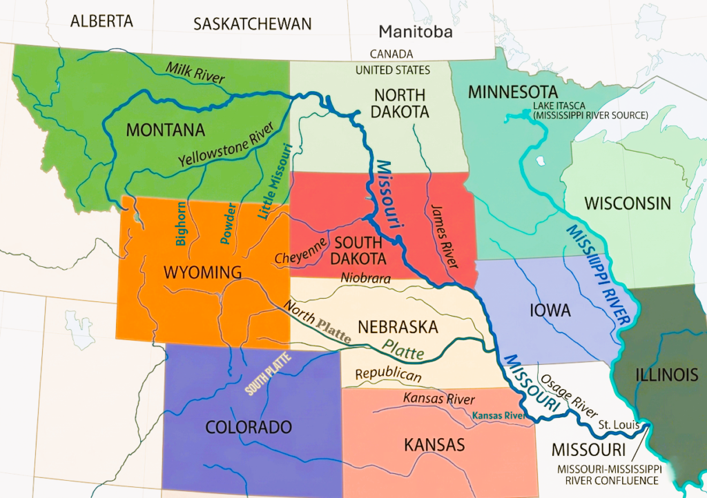
Left Bank Tributaries of Missouri River
The Missouri River receives several major tributaries from its left bank (eastern side when moving downstream). These rivers are crucial in supplying water, sediment, and ecological diversity from the Great Plains and Midwest. Many of them also mark important geographic and hydrologic transitions before the Missouri River reaches its confluence with the Mississippi River.
Milk River
The Milk River is a 729-mile-long one of the most distinctive left bank tributaries of the Missouri River. It originates in the Rocky Mountains of Montana and also receives flow from Alberta, Canada, before re-entering the United States. It joins the Missouri River near Fort Peck, Montana. The river is named for its milky appearance caused by glacial silt and fine sediments. It plays an important role in irrigation and water supply in the dry northern plains, especially during late summer when water levels can drop significantly.
Sun River
The Sun River is a shorter but important tributary in central Montana. It flows eastward from the Rocky Mountain Front and joins the Missouri River near Great Falls, Montana. The river is heavily influenced by snowmelt and irrigation return flows, making it important for agricultural lands in the region. It also contributes to maintaining seasonal water balance in the upper Missouri Basin.
Marias River
The Marias River, approximately 210 mile long, flows through northern Montana and joins the Missouri River near Loma, Montana. It drains a mix of mountain foothills and prairie landscapes, receiving water from snowmelt and rainfall. The Marias River is historically significant because it was explored during the Lewis and Clark Expedition, and it continues to serve as a key contributor to the Missouri River’s upper flow.
James River
The James River, also known as the “Jim River” or “Dakota River,” is a major tributary of the Missouri River that flows through the eastern Dakotas for approximately 710 miles. The river originates in Wells County, North Dakota, and flows generally south-southeast before joining the Missouri River near Yankton, South Dakota. Historically, this confluence was noted during the Lewis and Clark Expedition and became an important geographic landmark in the northern Great Plains.
Grand River
The Grand River is an important tributary of the Missouri River that flows for approximately 226 miles through Iowa and northwestern Missouri before joining the Missouri River near Brunswick, Missouri. The river drains a watershed of nearly 7,900 square miles, with more than three-fourths of the basin located within Missouri. It is considered the largest watershed feeding the Missouri River in northern Missouri and plays a significant role in the region’s agriculture, ecology, and water systems.
The river originates in southern Iowa and flows southward into Missouri, where its major forks merge near Albany. Several important tributaries contribute to the river system, including the Thompson River, Shoal Creek, Medicine Creek, and Locust Creek. Together, these waterways create a broad drainage network that supports farmland, wildlife habitats, and local communities across northern Missouri.
Chariton River
The Chariton River is a major tributary of the Missouri River that flows approximately 220 miles through southeastern Iowa and northeastern Missouri. Historically, it has been referred to as Missouri’s “Grand Divide” because streams west of the river drain toward the Missouri River system, while streams to the east eventually flow into the Mississippi River. This geographic position gives the river an important role within the larger watershed systems of the central United States.
The river originates in southeastern Clarke County, Iowa, and flows generally southeastward before entering Rathbun Lake, a large reservoir covering about 11,000 acres in Appanoose County. After passing through Rathbun Dam, the river continues south for roughly 30 miles before crossing into Missouri, where it forms part of the boundary between Putnam and Schuyler counties. It then flows through Adair and Macon counties before joining the Missouri River near Keytesville, Missouri.
Right Bank Tributaries of Missouri River
The Missouri River receives several important tributaries from its right bank (generally the western side when moving downstream). These tributaries mainly drain the Rocky Mountain foothills, High Plains, and parts of the central Great Plains, contributing significant snowmelt, rainfall runoff, and sediment to the river system.
Yellowstone River
The Yellowstone River, approximately 671–692 miles long, is one of the largest and most significant right bank tributaries of the Missouri River. It originates in Wyoming’s Absaroka Range and flows through Montana before entering North Dakota. The river joins the Missouri River near the town of Williston, North Dakota. It is one of the longest free-flowing rivers in the United States and contributes large volumes of snowmelt water, making it a major source of seasonal flow in the upper Missouri Basin. Its sediment load and natural flow patterns strongly influence river dynamics downstream.
Cheyenne River
The Cheyenne River, approximately 295 miles long, is one of the major right bank tributaries in South Dakota. It originates in Wyoming and flows eastward across the northern Great Plains before joining the Missouri River near the Oahe Reservoir in central South Dakota. The river drains a large semi-arid region and is strongly influenced by seasonal rainfall and flash flooding. It contributes significant sediment and runoff during storm events.
White River
The White River is a 580-mile-long tributary of the Missouri River that flows through Nebraska and South Dakota before joining the Missouri River in Lake Francis Case near Chamberlain, South Dakota. The river gets its name from the pale gray-white color of its water, caused by eroded sand, clay, and volcanic ash from the Badlands region. Rising in the Pine Ridge escarpment of northwestern Nebraska, it flows through grasslands, badlands, and the Pine Ridge Indian Reservation, draining a basin of about 10,200 square miles and supporting prairie ecosystems, wildlife habitats, and regional water systems.
Niobrara River
The Niobrara River is a scenic tributary of the Missouri River that originates in eastern Wyoming and flows for more than 500 miles across northern Nebraska before joining the Missouri River near the Nebraska–South Dakota border. Known for its shallow, gentle waters, sandstone bluffs, waterfalls, and forested valleys, the river is one of Nebraska’s most popular outdoor recreation destinations.
A 76-mile free-flowing section near Valentine is protected as the Niobrara National Scenic River and is widely used for tubing, kayaking, canoeing, and wildlife viewing. The river corridor contains more than 230 waterfalls, including Smith Falls, the tallest waterfall in Nebraska, and also supports important natural areas such as the Fort Niobrara National Wildlife Refuge.
Platte River
The Platte River is one of the most historically and geographically important tributaries in the Missouri River system. It is formed by the confluence of the North Platte and South Platte rivers in Nebraska and flows eastward across the state. The Platte River joins the Missouri River near Plattsmouth, Nebraska, just south of Omaha. Known for its wide, shallow, braided channel, it has long served as a key migration corridor for wildlife and as a historic travel route for westward expansion. It contributes substantial seasonal flow, especially during spring runoff.
Kansas River
The Kansas River , known locally as “the Kaw,” is a 173-mile-long major tributary in the lower basin, formed by the confluence of the Smoky Hill and Republican rivers in Kansas. It joins the Missouri River at Kansas City, Kansas/Missouri, one of the most important urban confluence zones in the entire river system. The Kansas River drains a large portion of eastern Kansas and contributes significant runoff from agricultural and urban landscapes. It also plays a key role in flood events due to its wide drainage area and variable rainfall patterns.
Frequently Asked Questions about Missouri River
Where does the Missouri River start and end?
The Missouri River begins at Three Forks, Montana, where the Jefferson, Madison, and Gallatin rivers converge. It flows generally east and south across the central United States until it joins the Mississippi River near St. Louis, Missouri.
How long is the Missouri River?
The Missouri River is approximately 2,341 miles long, making it the longest river in North America.
How deep is the Missouri River?
The river’s depth varies greatly depending on location and season. In the main navigation channel, it is typically around 10 to 20 feet deep, but in many areas it becomes much shallower, especially near sandbars and riverbanks.
What is the deepest point of the Missouri River?
The deepest sections of the Missouri River are generally found in its lower, channelized portions, where depths can exceed 40 feet in certain engineered navigation channels, depending on water levels and river management conditions.
Is the Missouri River the longest river in the world?
No, it is not the longest river in the world. The Missouri River is the longest river in the United States and a major tributary of the Mississippi River system.
How did the Missouri River get its name?
The river is named after the Missouri tribe, a Native American group that historically lived near its lower reaches. The name is believed to come from a Siouan language term meaning “people with wooden canoes.”
Why is it called the “Big Muddy”?
The Missouri River is called the “Big Muddy” because it carries extremely high amounts of sediment and silt. This gives the water a brown, muddy appearance, especially during periods of high flow and runoff.
What is the Missouri River also known as?
The Missouri River is often referred to as the “Mighty Mo” and is also historically called the “Big Muddy” due to its heavy sediment load and powerful flow.
Which states does the Missouri River flow through?
The river flows through or along seven U.S. states: Montana, North Dakota, South Dakota, Nebraska, Iowa, Kansas, and Missouri. Its larger watershed also extends into parts of additional states and even reaches into two Canadian provinces.
What is the meaning of the name “Missouri”?
The name “Missouri” comes from a Siouan language and is commonly interpreted as “people of the wooden canoe,” referring to Indigenous tribes that lived along the river and used it for transportation.
What was the Missouri River’s role in westward expansion?
The Missouri River played a major role in the westward expansion of the United States. It served as a key route for explorers such as the Lewis and Clark Expedition and later for settlers moving west, earning it the historic nickname “Gateway to the West.”
Is it safe to boat or float on the Missouri River?
Boating is possible, but caution is essential. The river has strong currents, shifting sandbars, and submerged debris. Water conditions can change quickly, so navigation experience and safety awareness are important.
What are the Missouri National Recreational River districts?
These are protected free-flowing sections of the Missouri River located between Nebraska and South Dakota. They are managed to preserve the river’s natural character, scenic beauty, and recreational value.
Are there dams on the Missouri River?
Yes, the river is heavily regulated by a system of six major mainstem dams, including Fort Peck, Garrison, Oahe, Big Bend, Fort Randall, and Gavins Point. These dams are managed primarily for flood control, hydroelectric power, irrigation, and navigation.
What is special about the Missouri River?
The Missouri River is unique because it combines extreme length, historical importance, ecological diversity, and economic value. It has shaped Native American cultures, supported westward expansion, and continues to serve as a major source of water, energy, agriculture, and transportation in the United States.
How long have people relied on the Missouri river as a source of transportation and food?
For over 12,000 years, people have depended on the Missouri River and its tributaries as a source of sustenance and transportation.