
Often called “The River of the West,”, the Columbia River flows approximately 1,243 miles from its source in British Columbia, Canada, to the Pacific Ocean near the border between Oregon and Washington. Its drainage basin covers around 258,000 square miles, making it one of the largest river systems in North America. The river drains portions of seven U.S. states and one Canadian province, creating an enormous interconnected watershed. It is a massive driver of hydroelectricity, agriculture, and Native American culture, while its scenic Gorge offers popular river cruising and tourism.
Origin of the Columbia River
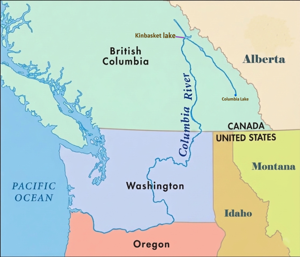
The Columbia River originates at Columbia Lake in the Rocky Mountain Trench of southeastern British Columbia, Canada. The lake lies at an elevation of approximately 2,690 feet above sea level and marks the beginning of the river’s 1,243-mile journey to the Pacific Ocean near Astoria.
The headwaters of the Columbia River begin in a mountainous and glacier-influenced region of the Canadian Rockies. Columbia Lake itself is a calm, narrow lake about 8 miles long, fed by surrounding streams, wetlands, snowmelt, and glacier runoff. These waters gradually gather to form the main channel of the Columbia River.
The river’s water system is closely connected to the Columbia Icefield in the Canadian Rockies. Meltwater from glaciers and alpine snowfields moves through interconnected wetlands and mountain streams before reaching Columbia Lake. This glacier-fed origin helps provide the river with a strong and consistent flow throughout much of the year.
One of the most unusual features of the Columbia River’s origin is its initial direction of flow. Instead of immediately heading south or west toward the Pacific Ocean, the river first flows north for nearly 200 miles through the Rocky Mountain Trench. Near Revelstoke, British Columbia, the river makes a major bend and turns southward, eventually crossing the Canada–United States border into Washington State.
Course of the Columbia River
The Columbia River flows approximately 1,243 miles from Columbia Lake in British Columbia, Canada, to the Pacific Ocean near Astoria. Its course passes through the Rocky Mountains, the Columbia Plateau, the Cascade Range, and coastal lowlands, making it one of the most geographically diverse rivers in North America.
Headwaters and Upper Course (British Columbia, Canada)
The Columbia River begins at Columbia Lake in the Rocky Mountain Trench of southeastern British Columbia. The headwaters are fed by glacier melt, snowmelt, wetlands, and mountain streams originating in the Canadian Rockies. Columbia Lake itself is a narrow freshwater lake located at an elevation of about 2,690 feet above sea level.
One of the river’s most unusual characteristics is its initial direction of flow. Instead of immediately flowing south toward the Pacific Ocean, the Columbia first travels northwest for nearly 190 miles through forested mountain valleys within the Rocky Mountain Trench. Near Revelstoke, British Columbia, the river makes a dramatic bend and turns southward for roughly 270 miles toward the Canada–United States border.
During this upper course, the river flows through rugged mountain terrain, deep valleys, and the dramatic Rocky Mountain Trench before entering several large reservoirs created by hydroelectric dams. Major reservoirs in this section include Kinbasket Lake, formed by Mica Dam; Lake Revelstoke, created by Revelstoke Dam; and the Arrow Lakes reservoir system, expanded by the Hugh Keenleyside Dam.
The region is heavily influenced by Rocky Mountain snowpack, glacier melt, and alpine runoff, which provide a continuous high-volume water supply and help maintain the river’s strong flow throughout the year.
The Big Bend and Central Washington
After crossing into northeastern Washington, the Columbia River enters one of the most distinctive sections of its course known as the “Big Bend.” In this region, the river sweeps south and west through central Washington in a massive geological arc.
The river flows across the Columbia Plateau, a broad volcanic region formed by ancient basalt lava flows. Over thousands of years, Ice Age floods carved dramatic landscapes throughout this area, including steep canyons, dry coulees, and layered basalt cliffs. One of the most famous landforms here is the Grand Coulee, a massive dry canyon created by prehistoric floodwaters.
This section of the river is also heavily developed for hydroelectric power and irrigation. Major dams such as Grand Coulee Dam and Chief Joseph Dam are located along the river in central Washington. Near Pasco, Washington, the Columbia receives its largest tributary, the Snake River, which significantly increases the river’s water volume and drainage area.
Columbia River Gorge and Border Region
Below the Snake River confluence, the Columbia River turns westward and begins forming much of the border between Washington and Oregon. This section contains the famous Columbia River Gorge, one of the most scenic and geologically significant river valleys in North America.
The gorge cuts directly through the Cascade Mountain Range and stretches for more than 80 miles between eastern Oregon and the Portland metropolitan region. Steep cliffs, waterfalls, volcanic rock formations, and dense forests dominate the landscape. The gorge also serves as a natural transportation corridor linking the Pacific coast with the interior Pacific Northwest.
Strong winds funneled through the gorge make this region internationally known for windsurfing and kiteboarding. Several major hydroelectric dams, including Bonneville Dam and The Dalles Dam, are also located along this stretch of the river.
Lower Columbia River and Mouth
After leaving the Columbia River Gorge, the river enters broader lowland regions near Portland and Vancouver. In this lower course, the river becomes wider and slower as it approaches the Pacific coast.
Near Vancouver, Washington, the Columbia briefly turns north before curving west again for its final stretch to the ocean. The river eventually empties into the Pacific Ocean at Astoria, Oregon, forming a large estuary where freshwater mixes with seawater.
Columbia River Estuary
The Columbia River Estuary is the large tidal mixing zone where the Columbia River meets the Pacific Ocean along the border of Oregon and Washington. Stretching approximately 146 miles inland from the Pacific Ocean to Bonneville Dam, the estuary is one of the most productive and ecologically important estuarine systems on the Pacific coast of North America.
Unlike a traditional sediment-built delta, the Columbia River forms a broad estuary where freshwater from the river mixes with saltwater from the Pacific Ocean. This interaction between river flow, ocean tides, and coastal currents creates a nutrient-rich environment that supports wetlands, fisheries, migratory birds, and diverse aquatic ecosystems throughout the lower Columbia Basin.
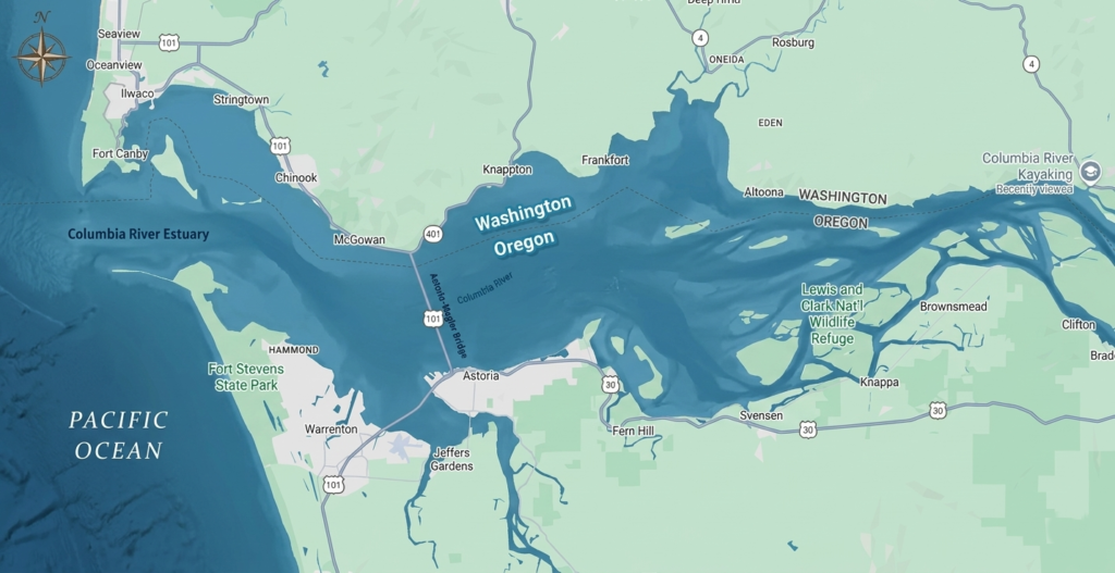
The estuary extends inland from the Pacific coast near Astoria and Cape Disappointment, Washington. It includes a complex network of tidal channels, marshes, swamps, sloughs, intertidal mudflats, and shallow bays. Constant tidal movement and changing salinity levels shape the estuary’s landscape and ecological conditions. These wetlands and tidal habitats also help absorb floodwaters, reduce erosion, filter pollutants, and improve water quality throughout the lower river system.
The Columbia River Estuary is internationally recognized for its ecological productivity and biodiversity. Nutrients carried downstream by the Columbia River combine with ocean nutrients from the Pacific to create rich feeding grounds for fish, birds, shellfish, and marine species. The estuary serves as a critical transition zone for juvenile salmon and steelhead migrating from inland rivers to the Pacific Ocean. Species such as Chinook salmon, Coho salmon, and steelhead trout rely on the estuary to gradually adapt from freshwater to saltwater before beginning their ocean migration.
The estuary also supports sturgeon, lamprey, crabs, shellfish, and numerous smaller fish species. Wetlands and tidal marshes act as nursery habitats for aquatic life, making the estuary essential to both freshwater and marine ecosystems across the Pacific Northwest.
The Columbia River Estuary is one of the most important bird habitats along the Pacific Flyway, the major migratory route used by birds traveling along the western coast of North America. Hundreds of thousands of shorebirds, ducks, geese, swans, and other migratory birds stop in the estuary during seasonal migrations. The region’s mudflats, wetlands, and marshes provide critical feeding and resting areas during these long journeys.
Because of its importance to migratory bird populations, parts of the lower estuary are recognized within the Western Hemisphere Shorebird Reserve Network. During spring migration especially, massive numbers of shorebirds gather in the estuary to feed on nutrient-rich tidal flats before continuing northward.
Large portions of the estuary are protected through wildlife refuges and conservation programs. The Lewis and Clark National Wildlife Refuge protects islands, tidal marshes, and swamps that provide habitat for migratory birds and aquatic species. Another important protected area is the Julia Butler Hansen National Wildlife Refuge, which contains more than 6,000 acres of tidal marsh and wetland habitat and serves as an important sanctuary for the endangered Columbian white-tailed deer.
Despite its ecological importance, the Columbia River Estuary faces several environmental challenges. Pollution from industrial, agricultural, and urban sources upstream affects water quality throughout the estuary. Wetland drainage, habitat conversion, dredging activities, and shoreline development have reduced natural habitats over time. Juvenile salmon populations are also threatened by habitat loss, altered river flows, and increased predation.
The Columbia River Estuary also supports regional economies through fishing, shipping, recreation, and tourism. Ports along the lower Columbia River serve as important trade centers connecting inland Pacific Northwest agriculture and industries with international markets. Recreational fishing, birdwatching, wildlife tourism, and boating are also major economic activities linked to the estuary.
The mouth of the Columbia River is also well known for dangerous navigation conditions. Strong river currents collide with Pacific Ocean waves, creating shifting sandbars and turbulent waters. This area became known as the “Graveyard of the Pacific” because of the large number of shipwrecks that occurred there historically.
Today, the Columbia River Estuary remains one of the most valuable natural environments in the Pacific Northwest. Its wetlands, fisheries, bird habitats, and tidal ecosystems play a critical role in connecting the Columbia River Basin with the Pacific Ocean while supporting both biodiversity and human activity along the Pacific coast.
Columbia River Basin
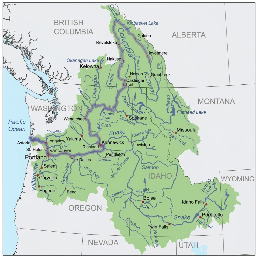
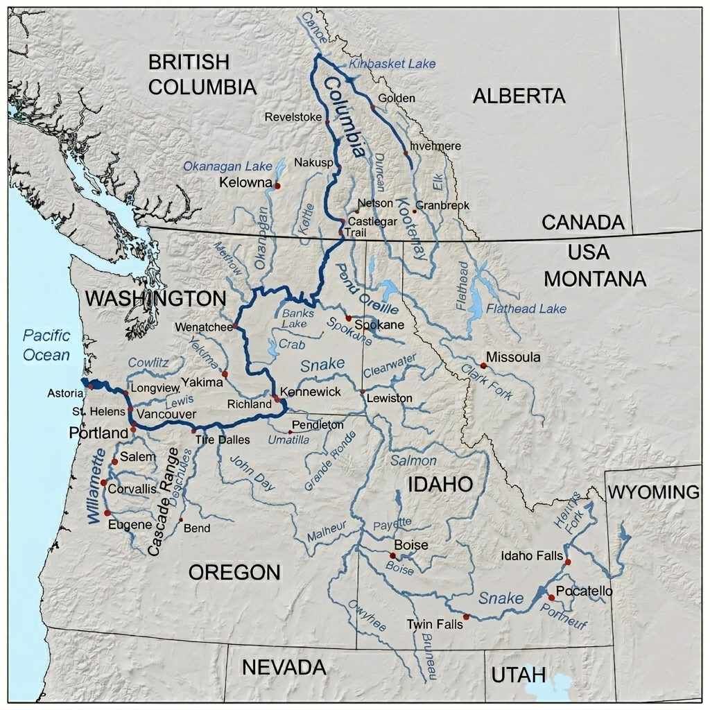
The Columbia River Basin is one of the largest river drainage systems in North America, covering approximately 258,000 square miles across the northwestern United States and western Canada. The basin includes the entire network of the Columbia River and its tributaries, stretching across British Columbia, Canada and seven U.S. states (Washington, Oregon, Idaho, Montana, Wyoming, Nevada, and Utah).
Upper Columbia River Basin
The Upper Columbia River Basin begins in the Rocky Mountains of southeastern British Columbia and extends into northeastern Washington. This region is characterized by rugged mountain landscapes, glacier-fed rivers, deep valleys, forests, and large lakes and reservoirs. Snowpack and glacier melt from the Canadian Rockies provide much of the water supply for the upper basin.
Major tributaries in this section include the Kootenay River, Pend Oreille River, and Spokane River. Large reservoirs and lakes dominate parts of the landscape, including Lake Roosevelt, which was formed behind Grand Coulee Dam.
The upper basin contains several important hydroelectric projects. Grand Coulee Dam is the largest hydropower producer in the United States and plays a major role in electricity generation, irrigation, and flood control throughout the Pacific Northwest. Other major dams include Chief Joseph Dam and multiple Canadian hydroelectric dams operated under the Columbia River Treaty between the United States and Canada.
Ecologically, the Upper Columbia Basin has become a major focus for salmon and steelhead restoration efforts. Historically, salmon migrated far upstream into Canada before dam construction blocked access to many spawning grounds. Modern restoration projects aim to improve fish habitats and support reintroduction programs above Grand Coulee Dam.
Middle Columbia River Basin
The Middle Columbia River Basin extends across central and eastern Washington and northern Oregon, covering much of the Columbia Plateau region. This area is dominated by semi-arid and arid landscapes shaped by ancient volcanic activity and Ice Age floods.
The basin in this region supports extensive agricultural development through irrigation systems supplied by the Columbia River and its tributaries. Large farming operations produce crops such as wheat, apples, potatoes, hops, and grapes across the plateau region.
Major tributaries in the middle basin include the Yakima River and the Snake River, the largest tributary of the Columbia River system. The confluence of the Snake and Columbia rivers near Pasco, Washington, is one of the most important fish migration corridors in the Pacific Northwest.
The middle basin also contains numerous hydroelectric dams including Priest Rapids Dam, Wanapum Dam, Rock Island Dam, Rocky Reach Dam, Wells Dam, McNary Dam, John Day Dam, and The Dalles Dam. These projects generate electricity, support navigation, and regulate river flow throughout the region.
Ecologically, this section of the basin contains critical spawning habitats and migratory channels for salmon and steelhead. Fish ladders and bypass systems have been constructed at major dams to support the movement of anadromous fish through the river system.
Lower Columbia River Basin
The Lower Columbia River Basin begins near the Columbia River Gorge and extends westward to the Pacific Ocean. This region includes the Cascade Mountains, coastal lowlands, wetlands, and the estuarine environments of the lower Columbia River.
One of the defining features of the lower basin is the Columbia River Gorge, where the river cuts through the Cascade Range between Washington and Oregon. Farther downstream, ocean tides influence the river system for up to 140 miles inland, creating complex estuarine conditions.
Major tributaries in the lower basin include the Cowlitz River, Lewis River, and Willamette River. The Willamette River joins the Columbia near Portland, significantly increasing water flow in the lower river system.
The major hydroelectric structure in this region is Bonneville Dam, the final dam on the Columbia River before it reaches the Pacific Ocean. Bonneville Dam plays an important role in hydropower generation, navigation, and fish passage management.
The Lower Columbia Basin is economically and ecologically important because it supports deep-water shipping corridors, major ports, fisheries, wetlands, and estuarine ecosystems. Important port cities include Portland, Oregon, and Vancouver.
This lower stretch of the river also forms the final migration route for salmon returning from the Pacific Ocean to inland spawning grounds. Wetlands and estuarine habitats throughout the basin provide critical nursery and feeding areas for fish, birds, and coastal wildlife.
Tributaries of the Columbia River
The Columbia River is supported by one of the largest and most complex tributary systems in North America. Hundreds of rivers and streams feed the Columbia throughout its 1,243-mile course from the Canadian Rockies to the Pacific Ocean. These tributaries supply water from glaciers, snowfields, forests, volcanic plateaus, wetlands, and mountain ranges across the Pacific Northwest.
The tributary network of the Columbia River stretches across British Columbia and seven U.S. states, forming the vast Columbia River Basin. Many of these tributaries are themselves major river systems with important ecological, economic, and historical significance. They provide irrigation water, hydroelectric power, fish habitat, transportation routes, and freshwater ecosystems throughout the region.
Tributaries of Columbia River in Canada
The Canadian portion of the Columbia River lies entirely within British Columbia and originates in the Rocky Mountain Trench. Major tributaries feeding the mainstem in Canada include the Kootenay, Pend Oreille, and Canoe rivers, alongside several glacial-fed tributaries from the surrounding mountain ranges.
Kootenay River
The Kootenay River (called Kootenai in the United States) is a 781-km tributary of the Columbia River. It begins in the Canadian Rockies of British Columbia, flows through Montana and Idaho, then returns to British Columbia before joining the Columbia River at Castlegar. The river passes through Kootenay Lake and the traditional territory of the Ktunaxa people. It is known for fishing, kayaking, wildlife, and scenic spots like Kootenai Falls.
Pend Oreille River
The Pend Oreille River is a 130-mile tributary of the Columbia River that flows from northern Idaho through Washington into British Columbia. It begins at Lake Pend Oreille and joins the Columbia River in southeastern British Columbia, where it is called the Pend-d’Oreille River. Hydroelectric development plays a major role along the river, with important dams including Albeni Falls Dam, Box Canyon Dam, Boundary Dam, Seven Mile Dam, and Waneta Dam.
Canoe River
The Canoe River is the northernmost tributary of the Columbia River in British Columbia. It flows south to join the Columbia at the famous “Big Bend,” where the river turns sharply southward. The lower section of the Canoe River was flooded by the Mica Dam project, creating the Canoe Reach of Kinbasket Lake.
Blaeberry River
The Blaeberry River is a 37-mile glacier-fed tributary of the Columbia River in the Canadian Rockies of British Columbia. It flows south from Howse Pass and joins the Columbia River near the mountain town of Golden.
Kicking Horse River
The Kicking Horse River is a scenic tributary of the Columbia River in southeastern British Columbia. Rising in Yoho National Park, the river is famous for its turquoise glacial waters and exciting Class II to IV whitewater rapids. It flows west through the town of Golden before joining the Columbia River. The Kicking Horse River is one of the top rafting destinations in the Canadian Rockies. The Upper Canyon offers calmer rapids for beginners, while the Middle and Lower Canyons feature powerful Class III and IV rapids popular with experienced rafters.
Spillimacheen River
The Spillimacheen River is a 73-mile tributary of the Columbia River in British Columbia. Rising near Glacier National Park, it flows through the Selkirk Mountains before joining the Columbia River near the community of Spillimacheen. Known for its steep mountain terrain and clear waters, the river is popular for fishing and advanced whitewater kayaking. The famous “Canyon Run” features demanding Class IV rapids and technical drops for experienced paddlers. The river is also used for hydropower through the Spillimacheen Dam.
Beaver River
The Beaver River is a tributary of the Columbia River in British Columbia. Flowing through the Selkirk Mountains, it enters the Columbia River system through Kinbasket Lake in the Rocky Mountain Trench northwest of Golden. The river is also known historically as Beavermouth Creek or Beaver Creek.
Illecillewaet River
The Illecillewaet River is a 39-mile tributary of the Columbia River in British Columbia. Rising from the Illecillewaet Glacier in Glacier National Park, it flows southwest through rugged mountain terrain before emptying into Upper Arrow Lake at the city of Revelstoke. Known for its fast-flowing glacial waters, the river is popular for Class III–IV whitewater rafting and kayaking. Because of heavy sediment and seasonal flooding risks, the river is actively managed with dikes and monitoring systems.
Incomappleux River
The Incomappleux River is a 42-mile tributary of the Columbia River in southeastern British Columbia. Rising in the Selkirk Mountains, it flows south into the Beaton Arm of Upper Arrow Lake near Revelstoke. The river valley is famous for its rare inland temperate rainforest, home to ancient cedar and hemlock forests, grizzly bears, bull trout, and diverse wildlife.
Tributaries of Columbia River in United States
The Columbia River has over 60 significant tributaries in the United States, spanning across the Pacific Northwest. Its largest and most significant tributaries—including the Snake, Willamette, and Cowlitz rivers—drain major portions of Idaho, Montana, Wyoming, Oregon, and Washington.
Snake River
The Snake River is a 1,078-mile tributary of the Columbia River and the largest river in its watershed. It begins in Yellowstone National Park and flows through Wyoming, Idaho, Oregon, and Washington before joining the Columbia River near the Tri-Cities area of Washington. The river is famous for landmarks such as Hells Canyon, the deepest river gorge in North America, and Shoshone Falls, often called the “Niagara of the West.” The Snake River Plain forms a major agricultural region in southern Idaho.
Spokane River
The Spokane River is a 111-mile tributary of the Columbia River that flows from northern Idaho into eastern Washington. Beginning at Lake Coeur d’Alene, the river passes through the city of Spokane, where the famous Spokane Falls are located, before emptying into Lake Roosevelt (Columbia River). Major tributaries include the Little Spokane River and Hangman Creek. For thousands of years, the Spokane River has held deep cultural importance for the Spokane Tribe of Indians and other Indigenous peoples of the Columbia Plateau.
Walla Walla River
The Walla Walla River is a 61-mile tributary of the Columbia River that flows through northeastern Oregon and southeastern Washington. Rising in the Blue Mountains, the river flows north through Milton-Freewater and Walla Walla County before joining the Columbia River near Wallula.
John Day River
The John Day River is a 284-mile tributary of the Columbia River and the longest free-flowing undammed river west of the Rocky Mountains in the contiguous United States. Rising in the Blue Mountains, it flows through northeastern and central Oregon before joining the Columbia River. The river is known for its rugged high-desert canyons, basalt cliffs, grasslands, and fossil-rich landscapes near the John Day Fossil Beds National Monument. It provides critical habitat for wild summer steelhead and spring Chinook salmon.
Deschutes River
The Deschutes River is a 252-mile tributary of the Columbia River in central Oregon. Rising at Little Lava Lake in the Cascade Range, it flows north through Bend before joining the Columbia River near The Dalles. Known as the “Peculiar River” for its steady year-round flow, the river passes through mountain forests, volcanic landscapes, and scenic high-desert canyons.
Willamette River
The Willamette River is a 187-mile tributary of the Columbia River that flows north through western Oregon. Rising in the Cascade Mountains, it passes through major cities including Eugene, Salem, and Portland before joining the Columbia River north of Portland. The river forms the backbone of the fertile Willamette Valley, home to most of Oregon’s population and famous wine-growing regions.
Kettle River
The Kettle River is a 175-mile undammed tributary of the Columbia River. Rising at Holmes Lake in the Monashee Mountains, it flows through southern British Columbia and northeastern Washington, crossing the Canada–U.S. border multiple times before joining Lake Roosevelt near Kettle Falls.
Sanpoil River
The Sanpoil River is a 70-mile tributary of the Columbia River in northeastern Washington. Flowing south from the town of Republic, the river passes through the Colville Indian Reservation before entering Lake Roosevelt near Keller Ferry. Named after the Sanpoil people, an Interior Salish tribe, the river remains culturally important to the Confederated Tribes of the Colville Reservation, which help manage and protect the watershed and wildlife habitat.
Okanogan River
The Okanogan River (called the Okanagan River in Canada) is a 115-mile tributary of the Columbia River. Rising from Okanagan Lake, it flows south through the Okanagan Valley and crosses into Washington before joining the Columbia River near Brewster. The river drains a semi-arid region east of the Cascade Range and passes communities including Kelowna, Oroville, Omak, and Okanogan. Its largest tributary is the Similkameen River.
Wenatchee River
The Wenatchee River is a 53-mile tributary of the Columbia River in central Washington. Beginning at Lake Wenatchee, the river flows southeast through the Cascade Mountains and joins the Columbia River near Wenatchee. Along its route, it passes communities such as Leavenworth, Cashmere, and Peshastin. Major tributaries include the Chiwawa River, Nason Creek, and Icicle Creek.
Yakima River
The Yakima River is a 214-mile tributary of the Columbia River in Washington. Rising in the Cascade Mountains, it flows southeast through the Yakima and Kittitas valleys before joining the Columbia River at Richland. One of its most scenic sections is the Yakima River Canyon, a dramatic basalt canyon between Ellensburg and Yakima known for rafting, kayaking, tubing, and wildlife viewing.
Lewis River
The Lewis River is a 95-mile tributary of the Columbia River in southwestern Washington. Rising on the western slopes of Mount Adams in the Cascade Mountains, the river flows west before joining the Columbia River. Its largest tributary, the East Fork Lewis River, is known for scenic swimming and hiking areas such as Moulton Falls Regional Park. The river is known for its scenic forests, waterfalls, and hydroelectric reservoirs, including Lake Merwin, Yale Lake, and Swift Reservoir. Outdoor recreation is especially popular near Cougar, where the Lewis River Trail leads to the scenic Lower Lewis River Falls, Middle Lewis River Falls, and Upper Lewis River Falls.
Cowlitz River
The Cowlitz River is a 105-mile tributary of the Columbia River in southwestern Washington. Rising in the Cascade Range near Mount Rainier and Mount Adams, the river flows through Lewis County before joining the Columbia River near Longview. Hydroelectric development has created major reservoirs along the river, including Lake Scanewa, Riffe Lake, and Mayfield Lake. Since the 1980 eruption of Mount St. Helens, the river system has faced major sediment and flooding challenges caused by volcanic debris carried by the Toutle River.
History of the Columbia River
The Columbia River is the largest river in the Pacific Northwest and one of the most historically important river systems in North America. Stretching approximately 1,240 miles from the Canadian Rockies to the Pacific Ocean, the river has shaped the geography, cultures, economies, and ecosystems of the Pacific Northwest for thousands of years.
For millennia, the Columbia River supported Indigenous communities, major salmon runs, transportation routes, and trading networks across the region. In modern times, the river became one of the most heavily engineered river systems in the world through the construction of hydroelectric dams, reservoirs, irrigation projects, and navigation channels.
Geological Origins
The origins of the Columbia River date back millions of years. Scientists believe the river system began forming between approximately 17 and 6 million years ago as volcanic activity, mountain uplift, and erosion shaped the Pacific Northwest landscape.
Massive basalt lava flows from volcanic eruptions covered large parts of the Columbia Plateau, creating thick layers of volcanic rock across present-day Washington, Oregon, and Idaho. As mountain ranges such as the Rockies and Cascades continued to rise, the Columbia River gradually carved pathways through valleys, plateaus, and canyons toward the Pacific Ocean.
One of the most dramatic events in the river’s geological history occurred near the end of the last Ice Age about 15,000 years ago. Repeated failures of Glacial Lake Missoula unleashed catastrophic floods across the Pacific Northwest. These floods carved deep canyons, reshaped valleys, and helped form features such as the Columbia River Gorge. The floods also created dry coulees, basalt cliffs, and scoured landscapes throughout the Columbia Basin.
Indigenous Heritage
The Columbia River Basin has been home to Indigenous peoples for thousands of years. The river served as a center of food, trade, transportation, and spiritual life for many tribal nations throughout the Pacific Northwest.
Indigenous peoples including the Chinook, Yakama, Umatilla, Nez Perce, Spokane, Colville, and Wishram established villages and fishing sites along the Columbia River and its tributaries. Canoe routes on the river connected coastal and inland communities, supporting extensive regional trade networks long before European arrival.
Salmon played a central role in Indigenous cultures throughout the Columbia Basin. Seasonal salmon runs provided a reliable food source and became deeply connected to ceremonies, traditions, and community life. One of the most important fishing locations was Celilo Falls, where Indigenous communities gathered for fishing and trade for thousands of years.
The Columbia River supported one of the largest salmon migrations in the world. Millions of salmon historically traveled upriver from the Pacific Ocean into tributaries across the basin to spawn in mountain streams and rivers.
European Exploration and Naming
European exploration of the Columbia River began during the eighteenth century as Spanish, British, and American expeditions explored the Pacific Northwest coast.
In 1775, Spanish explorer Bruno de Heceta became one of the first Europeans to sight the mouth of the river from the Pacific coast. However, he did not fully enter or map the river because of dangerous currents and shifting sandbars near the river mouth.
In 1792, American sea captain Robert Gray successfully crossed the dangerous Columbia Bar and entered the river. He named the river after his ship, the Columbia Rediviva. Gray’s voyage strengthened American territorial claims in the Pacific Northwest.
Soon afterward, British explorer George Vancouver surveyed nearby coastal regions, while Canadian explorer David Thompson later mapped much of the upper Columbia Basin.
Lewis and Clark Expedition
The Columbia River gained national importance in the United States after the Lewis and Clark Expedition reached the river system in 1805.
Led by Meriwether Lewis and William Clark, the expedition traveled down the Snake and Columbia rivers to reach the Pacific Ocean. Along the journey, the explorers documented the geography, wildlife, Indigenous communities, and resources of the Columbia Basin.
The expedition eventually established winter quarters near present-day Astoria, Oregon, before returning eastward in 1806. Their reports increased American interest in settlement, trade, and territorial expansion in the Pacific Northwest.
Fur Trade and Settlement Era
During the nineteenth century, the Columbia River became the center of the Pacific Northwest fur trade. British and Canadian trading companies established forts and trading posts throughout the basin.
The Hudson’s Bay Company became the dominant commercial power in the region. Fort Vancouver served as the company’s headquarters west of the Rocky Mountains and became a major trading and supply center along the lower Columbia River.
Competition between British fur traders and expanding American interests increased during this period. The river also became an important transportation corridor for settlers moving westward into the Oregon Territory.
Steamboats later transformed river transportation, allowing goods, passengers, and agricultural products to move more efficiently throughout the Pacific Northwest.
The Oregon Boundary and Territorial Expansion
The Columbia River played an important role in territorial disputes between the United States and Great Britain during the nineteenth century. Both nations claimed control over the Oregon Country, which included much of the Pacific Northwest.
For a period, the Columbia River itself was proposed as a possible international boundary. However, the dispute was eventually resolved through the Oregon Treaty, which established the forty-ninth parallel as the border west of the Rocky Mountains.
This agreement left the Columbia River’s headwaters in British Columbia while placing most of the basin south of the Canadian border under United States control.
The Dam Era and Hydroelectric Development
Beginning in the 1930s, the Columbia River entered a new era of large-scale engineering and hydroelectric development. Governments and utilities viewed the river as a major source of electricity, irrigation water, flood control, and inland navigation.
The first major hydroelectric projects included Bonneville Dam and Grand Coulee Dam. Grand Coulee Dam became the largest hydropower producer in the United States and helped transform agriculture and industry throughout the Pacific Northwest.
Over time, more than 200 dams were constructed throughout the Columbia River Basin and its tributaries. Additional projects such as Chief Joseph Dam, The Dalles Dam, John Day Dam, and McNary Dam further altered the river system.
Hydroelectric power from the Columbia Basin became especially important during World War II, supporting aluminum production, wartime manufacturing, and regional industrial growth.
Ecological and Cultural Impacts
Although dams provided electricity, irrigation, and flood protection, they also caused major environmental and cultural changes throughout the Columbia Basin.
Reservoir construction flooded villages, wetlands, rapids, and fishing grounds that Indigenous peoples had used for thousands of years. One of the most significant losses occurred in 1957 when Celilo Falls was submerged following the completion of The Dalles Dam.
Dams also disrupted natural salmon migration routes. Fish populations declined sharply because of blocked spawning habitat, altered river flows, pollution, and habitat destruction. Fish ladders, hatcheries, and restoration programs were later introduced to help improve fish survival, but many salmon populations remain threatened.
The engineering of the river also changed sediment transport, water temperatures, wetlands, and estuarine ecosystems throughout the Columbia Basin.
Modern Era and Restoration Efforts
Today, the Columbia River remains one of the most economically important rivers in North America. It supports hydroelectric power generation, irrigation, shipping, agriculture, fishing, tourism, and recreation throughout the Pacific Northwest.
Major ports along the lower Columbia River connect inland agricultural and industrial regions with global trade routes through the Pacific Ocean. Cities such as Portland and Vancouver continue to depend heavily on the river system.
At the same time, modern environmental efforts focus on restoring salmon habitats, improving fish passage systems, reconnecting wetlands, and modernizing aging infrastructure. Conservation groups, tribal nations, scientists, and governments continue working to balance hydropower production with ecosystem protection.
Climate change, drought, warming water temperatures, and declining snowpack now present additional long-term challenges for the Columbia River Basin. Despite these pressures, the Columbia River remains the defining natural system of the Pacific Northwest and continues to shape the region’s environment, economy, and cultural identity.
Dams on the Columbia River
The Columbia River is one of the most heavily engineered river systems in the world. Stretching from the Canadian Rockies to the Pacific Ocean, the river supports a massive network of hydroelectric dams that provide electricity, irrigation, flood control, navigation, and water storage throughout the Pacific Northwest.
The main stem of the Columbia River contains 14 major dams located across British Columbia, Washington, and the Washington–Oregon border region. Together, these projects transformed the economy and landscape of the Columbia Basin during the twentieth century. The dams generate huge amounts of renewable electricity and support agriculture, transportation, and urban development across the northwestern United States and western Canada.
At the same time, the dams significantly altered the river’s natural ecosystems, particularly salmon migration routes and Indigenous fishing grounds. Today, the Columbia River dams remain central to both regional infrastructure and environmental debates.
| # | Dam Name | Location | Height | Key Detail |
|---|---|---|---|---|
| 1 | Mica Dam | British Columbia, Canada | 790 ft | One of the tallest earth-fill dams in the world; built under the Columbia River Treaty. |
| 2 | Revelstoke Dam | British Columbia, Canada | 574 ft | A massive concrete gravity dam that harnesses water released directly from the Mica Dam upstream. |
| 3 | Hugh Keenleyside Dam | British Columbia, Canada | 171 ft | Primarily built for flood control storage; controls the massive Arrow Lakes reservoir system. |
| 4 | Grand Coulee Dam | Washington, USA | 550 ft | The largest power plant in the United States; completely blocks upstream fish passage because it lacks fish ladders. |
| 5 | Chief Joseph Dam | Washington, USA | 236 ft | The second-largest hydropower producer in the United States; acts as the lower limit for salmon migration. |
| 6 | Wells Dam | Washington, USA | 160 ft | Features a unique hydrocombine design combining the powerhouse, spillway, and fish ladders into one structure. |
| 7 | Rocky Reach Dam | Washington, USA | 130 ft | Known for its extensive fish bypass system designed to protect juvenile salmon. |
| 8 | Rock Island Dam | Washington, USA | 135 ft | Completed in 1933, it was the first dam built across the main stem of the Columbia River. |
| 9 | Wanapum Dam | Washington, USA | 185 ft | Named after the Wanapum people and features advanced fish-friendly turbines. |
| 10 | Priest Rapids Dam | Washington, USA | 178 ft | Located upstream of the Hanford Site and marks the upper limit of the Hanford Reach. |
| 11 | McNary Dam | Washington/Oregon, USA | 183 ft | A major navigation link featuring a single-lift lock for commercial barge traffic. |
| 12 | John Day Dam | Washington/Oregon, USA | 183 ft | Features one of the highest single-lift locks in the world and maintains flood-storage capacity. |
| 13 | The Dalles Dam | Washington/Oregon, USA | 200 ft | Its 1957 construction submerged Celilo Falls, an ancient Indigenous fishing and trading center. |
| 14 | Bonneville Dam | Washington/Oregon, USA | 197 ft | The final dam before the Pacific Ocean; known for its underwater salmon-viewing windows. |
Dams on the Columbia River in Canada (British Columbia)
Mica Dam
The Mica Dam is a massive earth-fill hydroelectric dam on the Columbia River in British Columbia, about 135 km north of Revelstoke. Completed in 1973 under the Columbia River Treaty, the 240 m (787 ft) dam forms the huge Kinbasket Reservoir and is one of BC Hydro’s largest power-generating facilities, producing over 2,800 MW of electricity. It is also important for flood control, water regulation, and recreation.
Revelstoke Dam
The Revelstoke Dam is a major hydroelectric dam on the Columbia River, located about 5 km north of Revelstoke in British Columbia. The 175 m (575 ft) dam was completed in 1984 and has a generating capacity of 2,480 MW from five turbines, supplying around 15% of British Columbia’s electricity. The site also features a popular visitor centre with river views, guided tours, interactive exhibits, and displays on local Indigenous history.
Hugh Keenleyside Dam
The Hugh Keenleyside Dam is a flood-control and water-storage dam on the Columbia River, located about 12 km upstream from Castlegar. Completed in 1968 under the Columbia River Treaty, the 52 m (171 ft) earth-and-concrete dam creates Lower Arrow Lake and helps regulate river flow for downstream hydroelectric generation. Originally called the High Arrow Dam, it was renamed after Hugh Llewellyn Keenleyside in 1969. The area also features parks, boating access, and a navigation lock for vessels bypassing the dam.
Dams on the Columbia River in the United States (Washington & Oregon)
Grand Coulee Dam
The Grand Coulee Dam is a massive concrete gravity dam on the Columbia River and the largest power station in the United States, with a generating capacity of 6,809 MW. Built between 1933 and 1942 as part of New Deal under President Franklin D. Roosevelt, the dam stands 550 ft (168 m) tall and stretches nearly a mile across the river.
The dam plays a major role in hydroelectric power generation, flood control, and irrigation through the Columbia Basin Project, which supplies water to nearly 700,000 acres of farmland. It also forms Franklin Delano Roosevelt Lake, a popular recreation area for boating, fishing, and camping. Visitors can explore exhibits, guided tours, and the famous summer laser light show projected onto the spillway.
Despite its engineering significance, the dam has also been criticized for blocking historic salmon migrations and flooding important Indigenous cultural lands. Ongoing restoration projects now focus on salmon reintroduction and ecological recovery.
Chief Joseph Dam
The Chief Joseph Dam is a large concrete gravity dam on the Columbia River near Bridgeport, Washington. Operated by the U.S. Army Corps of Engineers, it is the world’s largest run-of-the-river hydroelectric power station and the second-largest hydropower producers in the United States, with an installed capacity of more than 2,600 MW from 27 turbines.
Completed between 1951 and 1958, the dam was named after Chief Joseph, the respected leader of the Wallowa Band of the Nez Perce people. The reservoir behind the dam forms Rufus Woods Lake, a popular recreation area known for boating, camping, and excellent rainbow trout fishing. Besides electricity generation, the dam also supports flood control and regional water management.
Wells Dam
The Wells Dam is a hydroelectric embankment dam on the Columbia River in north-central Washington near Pateros. Opened in 1967, the dam is part of the Wells Hydroelectric Project and is known for its unique “hydrocombine” design, which integrates spillways and powerhouses into a single structure. The dam has 10 generating units with a combined capacity of about 855 MW and creates Lake Pateros, a 30-mile-long reservoir used for boating and fishing.
Rocky Reach Dam
The Rocky Reach Dam is a hydroelectric dam on the Columbia River, located about 7 miles north of Wenatchee, Washington. The dam was built along a narrow section of the Columbia River in Washington State and generates substantial hydroelectric power for the regional grid.
Rocky Reach Dam is widely recognized for its advanced fish bypass systems designed to protect juvenile salmon during downstream migration. Visitors can watch migrating salmon and steelhead through fish-viewing windows along the fish ladder.
Rock Island Dam
The Rock Island Dam is a hydroelectric dam on the Columbia River in central Washington, about 12 miles downstream from Wenatchee. Built between 1929 and 1933, it was the first dam to span the entire Columbia River and became a pioneering project for later major dams in the Pacific Northwest.
Wanapum Dam
The Wanapum Dam is a run-of-the-river hydroelectric dam on the Columbia River in central Washington, located near Vantage where Interstate 90 crosses the river. The dam began generating power in 1963 and creates Lake Wanapum. It was named after the Wanapum people, a Native American community historically connected to the region.
In 2014, engineers discovered a major crack within the dam structure, leading to a large-scale repair project and temporary lowering of the reservoir. After extensive stabilization work, the dam was successfully repaired and normal water levels were restored in 2015.
Priest Rapids Dam
The Priest Rapids Dam is a large hydroelectric concrete gravity dam on the Columbia River in Grant and Yakima counties, Washington. The reservoir behind the dam forms Priest Rapids Lake, a popular area for boating, fishing, and camping. The dam marks the upper boundary of the Hanford Reach, one of the last free-flowing sections of the Columbia River in the United States. This stretch remains critically important for salmon spawning and river ecology.
McNary Dam
The McNary Dam is a major hydroelectric concrete gravity dam on the Columbia River, located between Umatilla County, Oregon, and Benton County, Washington. Built by the U.S. Army Corps of Engineers between 1947 and 1956, the dam is about 1.4 miles long and generates roughly 980 MW of electricity
The dam supports hydroelectric power generation, flood control, river navigation, and fish migration. It includes a large navigation lock for commercial barges as well as fish ladders and a juvenile fish facility that help salmon and steelhead safely bypass the turbines during migration. The dam was named after Charles L. McNary, a longtime advocate for Pacific Northwest development and conservation projects.
John Day Dam
The John Day Dam is a large hydroelectric concrete gravity dam on the Columbia River near Rufus, Oregon. Completed in 1971 by the U.S. Army Corps of Engineers, the dam is one of the Pacific Northwest’s largest hydropower facilities, with a generating capacity of 2,160 MW.
The dam is especially known for having the highest single-lift navigation lock in the Western Hemisphere, capable of raising or lowering vessels by up to 113 feet. It also creates Lake Umatilla, a 110-mile-long reservoir used for flood control, navigation, and recreation. Advanced fish ladders and monitoring systems help salmon and other migratory fish safely pass the dam. The surrounding area is popular for boating, fishing, swimming, and windsurfing.
The Dalles Dam
The The Dalles Dam is a large concrete-gravity hydroelectric dam on the Columbia River between Wasco County, Oregon, and Klickitat County, Washington. Built between 1952 and 1957 by the U.S. Army Corps of Engineers, the dam has a distinctive “Z” shape and generates about 1.8 million kilowatts of renewable electricity. Its reservoir forms Lake Celilo. The dam includes a major navigation lock that lifts commercial barges around the structure and supports regional river transport. Its construction permanently flooded Celilo Falls, an important Native American fishing and cultural site along the Columbia River.
Bonneville Dam
Bonneville Dam was the first major federal dam constructed on the Columbia River. Completed in 1938 within the Columbia River Gorge, the project played a major role in transforming the Pacific Northwest economy. Its lock system allows barges and ships to safely bypass the dangerous rapids of the Columbia River Gorge.
Bonneville Dam generates hydroelectric power, improves river navigation, and regulates water flow near the lower Columbia River. The project also contains highly visited underwater salmon-viewing windows that allow visitors to observe migrating fish.
As the final dam before the Pacific Ocean, Bonneville plays a crucial role in managing salmon migration between the ocean and upstream spawning grounds.
Ports on the Columbia River
The Columbia River supports one of the most important inland and coastal port systems in North America. Stretching from the Pacific Ocean deep into the interior Pacific Northwest, the Columbia River port network connects Oregon, Washington, and inland agricultural regions to global trade markets.
The river functions as a major commercial transportation corridor through a federally maintained navigation channel that allows ocean-going vessels, barges, and cargo ships to move far inland. Deep-water ports near the Pacific coast handle international shipping traffic, while inland ports farther upriver support agriculture, industry, energy, and regional transportation.
The Columbia River port system plays a critical role in grain exports, container shipping, timber transport, industrial manufacturing, and bulk commodity trade throughout the Pacific Northwest.
Lower Columbia River Ports
The lower Columbia River contains the largest deep-water ports in the river system. These ports are located closest to the Pacific Ocean and are capable of handling large cargo ships, bulk carriers, cruise vessels, and international container traffic.
The lower river benefits from a deep federally maintained navigation channel that allows ocean-going vessels to travel inland from the Pacific Ocean.
Port of Astoria
Port of Astoria is located near the mouth of the Columbia River close to where the river enters the Pacific Ocean. It is one of the oldest ports in the Pacific Northwest and has historically served as a major commercial fishing center. Today, the port supports fishing fleets, seafood processing, tourism, cruise ship operations, and general cargo handling. Its location near the Pacific coast gives it strategic importance for maritime commerce and ocean access. The surrounding Astoria region also has deep historical connections to early exploration and the fur trade era of the Columbia River.
Port of Columbia County
Port of Columbia County, formerly known as the Port of St. Helens, oversees several industrial terminals along the lower Columbia River in Oregon. The port handles bulk liquids, industrial materials, forest products, and manufacturing operations. It also manages industrial properties and transportation infrastructure that support economic development throughout Columbia County. Its river access and transportation links make it an important industrial hub within the lower Columbia region.
Port of Vancouver USA
Port of Vancouver USA is one of the largest and busiest ports on the Columbia River. Located in southwestern Washington, the port handles grain exports, automobiles, steel, wind energy components, and breakbulk cargo. The port is strategically connected to railroads, highways, and river transportation systems, allowing efficient cargo movement between inland agricultural regions and international shipping markets. The Port of Vancouver also plays a major role in Pacific Northwest export activity, particularly for wheat and other agricultural commodities.
Port of Portland
Port of Portland is the largest port in Oregon and one of the most important transportation hubs in the Pacific Northwest. Located near the confluence of the Columbia and Willamette River, the port manages cargo terminals, industrial facilities, bulk shipping operations, and transportation infrastructure throughout the Portland metropolitan area. In addition to marine cargo operations, the Port of Portland also operates Portland International Airport, making it a major multimodal transportation authority in the region. The port handles grain, automobiles, minerals, steel, energy products, and containerized cargo linked to global trade networks.
Middle Columbia River Ports
Farther inland, the middle Columbia River contains a mixture of deep-water and industrial ports that continue to support international shipping and regional transportation. These ports rely on the maintained navigation channel and lock systems that allow vessels to travel inland through the Columbia River system.
Port of Kalama
Port of Kalama is located along the lower-middle Columbia River in Washington State. The port is internationally recognized as a major agricultural export gateway. Large quantities of grain and other farm products move through the port to overseas markets, particularly in Asia. The port also supports industrial development, rail transportation, and manufacturing facilities.
Port of Longview
Port of Longview is one of the largest deep-water ports on the Columbia River. The port specializes in bulk exports, breakbulk cargo, and heavy-lift shipping operations. Major commodities handled at the port include timber products, minerals, agricultural goods, and industrial equipment. The port’s large industrial facilities and transportation infrastructure support regional manufacturing and export industries.
Port of Woodland
Port of Woodland supports industrial development, transportation logistics, and river-to-rail cargo transfers along the Columbia River. The port manages industrial parks, manufacturing properties, and transloading facilities that connect river shipping with rail transportation systems. These services help support regional agricultural and industrial economies.
Upper Columbia River Ports
Beyond Bonneville Dam, the Columbia River transitions into a lock-and-dam navigation system with shallower channels generally ranging between 14 and 17 feet deep. This inland navigation system allows barges and cargo vessels to travel far upriver into eastern Washington and Idaho. Upper Columbia River ports mainly focus on agriculture, industry, energy transportation, and regional economic development.
Port of Hood River
Port of Hood River is located within the Columbia River Gorge and supports marina operations, recreation, tourism, and light industrial activities. The port also manages waterfront properties and transportation facilities that contribute to the regional economy.
Port of The Dalles
Port of The Dalles serves as an important inland industrial and agricultural port along the middle Columbia River. The port supports grain shipping, industrial manufacturing, food processing, and transportation infrastructure throughout north-central Oregon. Its location along major rail and highway routes strengthens its role as a regional trade and logistics center.
Port of Morrow
Port of Morrow is the second-largest port district in Oregon and one of the largest industrial and agricultural hubs in the Columbia Basin. Located near Boardman, the port supports grain exports, food processing, energy development, warehousing, and transportation logistics. Extensive rail, highway, and river connections allow the port to move large volumes of agricultural products to international markets.
Port of Arlington
Port of Arlington is an inland Columbia River port focused on agriculture, transportation, and wind energy logistics. The port supports the movement of grain, industrial equipment, and renewable energy infrastructure throughout the region. Its location along the Columbia River and Interstate 84 provides important transportation advantages for eastern Oregon industries.
Port of Pasco
Port of Pasco is located within Washington’s Tri-Cities region and provides major river, rail, and highway transportation connections. The port supports agricultural exports, food processing, industrial operations, and regional logistics throughout southeastern Washington.
Port of Kennewick
Port of Kennewick focuses heavily on economic development, marina facilities, industrial properties, and waterfront management. Located in the Tri-Cities area, the port supports commercial growth, recreation, tourism, and business expansion along the Columbia River.
Cities Along the Columbia River
The Columbia River flows through some of the most historically, economically, and geographically important cities in the Pacific Northwest. Stretching from the Canadian Rockies to the Pacific Ocean, the river has shaped settlement patterns, transportation networks, agriculture, trade, hydroelectric development, and industry across western Canada and the northwestern United States.
Cities along the Columbia River developed because of access to water, fishing resources, navigation routes, fertile land, and later hydroelectric power and port infrastructure. Today, these cities continue to play major roles in shipping, manufacturing, tourism, agriculture, and regional commerce throughout the Columbia Basin.
Cities Along the Columbia River in Canada
The Canadian stretch of the Columbia River passes through several important towns and cities that developed around transportation, forestry, mining, tourism, hydroelectric power, and river-based trade. These communities are closely connected to the geography and water systems of the upper Columbia Basin.
Canal Flats
Canal Flats is located at the southern end of Columbia Lake and is widely recognized as the official source community of the Columbia River. The village lies within the Rocky Mountain Trench, a massive geological valley that guides the river’s early course through southeastern British Columbia. The surrounding landscape contains wetlands, forests, and mountain scenery that form part of the river’s headwaters ecosystem. Historically, Canal Flats served as an important transportation point because of its location near waterways connecting the Columbia and Kootenay river systems.
Invermere
Invermere is one of the main population centers in the Columbia Valley and sits near Windermere Lake along the Columbia River system. The town is known for tourism, recreation, and access to nearby mountains, lakes, and wetlands. The Columbia River flows through extensive marshes and wetland areas near Invermere, supporting wildlife habitats and migratory bird populations.
Radium Hot Springs
Radium Hot Springs is located near the Columbia Wetlands at the entrance to Kootenay National Park. The community is famous for its natural hot springs and dramatic mountain scenery. The nearby Columbia Wetlands form one of the largest intact wetland systems in North America and play an important ecological role within the upper Columbia Basin.
Golden
Golden is located between the Rocky Mountains and Columbia Mountains near the upper Columbia River. The town developed historically as a railway and forestry center but is now widely recognized for tourism and outdoor recreation. Extensive wetlands and floodplain systems surrounding Golden support important habitats connected to the Columbia River. Golden also serves as a gateway to several national parks and mountain recreation areas in southeastern British Columbia.
Revelstoke
Revelstoke is one of the most prominent cities along the upper Columbia River. Situated between the Monashee and Selkirk mountain ranges, the city lies directly along the river and near major hydroelectric projects including Revelstoke Dam. Revelstoke became an important railway center during the nineteenth century and later developed into a major hub for hydropower, forestry, and tourism. Today, the city is internationally known for skiing, mountain recreation, and outdoor adventure tourism.
Castlegar
Castlegar is located at the confluence of the Columbia and Kootenay River. The city serves as an important transportation, industrial, and cultural center in the West Kootenay region. Forestry, mining, hydroelectric development, and regional trade all contributed to Castlegar’s growth. Its strategic location at the meeting point of two major river systems gives the city an important role within the Columbia Basin.
Trail
Trail lies downstream from Castlegar along the Columbia River and is one of the most historically significant industrial communities in the Canadian Columbia Basin. The city became famous for its large zinc and lead smelting complex, which developed using hydroelectric power generated from the Columbia River system. Trail’s steep hillsides and terraced urban layout overlook the river valley below. Mining and metallurgy shaped much of the city’s economic history, and Trail continues to serve as an important industrial center in southeastern British Columbia.
Cities Along the Columbia River in the United States
The Columbia River flows through the states of Washington and Oregon, linking inland agricultural regions with major ports and the Pacific Ocean. Cities along the American section of the river range from historic coastal settlements and industrial ports to scenic gorge communities and large metropolitan centers.
The river has played a major role in shaping trade, transportation, hydropower development, agriculture, tourism, and recreation throughout the Pacific Northwest. Today, Columbia River cities continue to support international shipping, outdoor recreation, energy production, and regional commerce.
The Dalles, Oregon
The Dalles is one of the oldest and largest communities in the Columbia River Gorge region. Historically, the city became an important stop along the Oregon Trail and later developed into a transportation and trade center because of its strategic river location. The nearby The Dalles Dam remains one of the major hydroelectric projects on the Columbia River. Agriculture, food processing, transportation, and tourism continue to support the local economy.
Hood River, Oregon
Hood River is internationally known as one of the world’s premier destinations for windsurfing and kiteboarding. Located within the Columbia River Gorge, the city benefits from strong wind conditions created by the surrounding mountain terrain. The area also offers spectacular views of Mount Hood and attracts visitors for hiking, skiing, cycling, and outdoor recreation. Fruit orchards, vineyards, tourism, and recreation industries play major roles in the local economy.
Stevenson, Washington
Stevenson sits along the northern side of the Columbia River Gorge in southwestern Washington. The town is known for dramatic basalt cliffs, scenic riverfront parks, and outdoor recreation opportunities connected to the Columbia River and nearby mountains. Stevenson also serves as a gateway to hiking, waterfalls, and forested landscapes within the gorge region. Tourism and recreation remain central to the town’s economy.
Cascade Locks, Oregon
Cascade Locks developed historically around river navigation and transportation along the Columbia River. The town is famous for the Bridge of the Gods, which spans the Columbia River between Oregon and Washington. It is also an important access point for the Pacific Crest Trail. Cascade Locks remains closely connected to tourism, recreation, boating, and river-based activities within the gorge.
Washougal and Camas, Washington
Washougal and Camas are neighboring communities located along the Columbia River east of Vancouver. These cities are known for scenic waterfronts, outdoor recreation, and access to nearby hiking areas such as Cape Horn Trail. Residential growth, recreation, and tourism have increasingly shaped the region’s economy in recent decades.
Portland, Oregon
Portland is the largest city connected to the Columbia River system and one of the most important economic centers in the Pacific Northwest. Located near the confluence of the Columbia and Willamette River, Portland developed into a major international shipping and manufacturing hub because of river transportation and Pacific trade access. The Port of Portland handles large volumes of cargo including grain, automobiles, minerals, and industrial products. Riverfront parks, recreation areas, bridges, and waterfront redevelopment projects also make the Columbia River an important part of the city’s identity.
Vancouver, Washington
Vancouver lies directly across the Columbia River from Portland and forms part of the larger Portland metropolitan area. The city has historic importance because Fort Vancouver once served as the western headquarters of the Hudson’s Bay Company during the fur trade era. Modern Vancouver features a revitalized waterfront district with restaurants, parks, walking trails, and riverfront development. The Port of Vancouver USA remains one of the busiest ports on the Columbia River.
Longview, Washington
Longview developed as a major industrial city along the lower Columbia River. The city became strongly associated with timber processing, paper production, manufacturing, and river shipping during the twentieth century. Tree-lined streets, parks, and waterfront industries continue to shape the character of the city today. The nearby Port of Longview is one of the most important deep-water ports on the Columbia River.
Astoria, Oregon
Astoria is located near the mouth of the Columbia River where it enters the Pacific Ocean. Founded in 1811, Astoria is the oldest American settlement west of the Rocky Mountains. The city historically depended on fishing, maritime trade, fur trading, and shipping industries connected to the Columbia estuary.
Tri-Cities, Washington
The Tri-Cities region includes Kennewick, Pasco, and Richland. Located near the confluence of the Columbia, Snake, and Yakima rivers, the Tri-Cities area became one of the Pacific Northwest’s most important agricultural and economic hubs. The region supports large-scale farming, food processing, wine production, research facilities, transportation infrastructure, and energy industries. River access and irrigation from the Columbia Basin transformed the surrounding landscape into highly productive farmland.
Wenatchee, Washington
Wenatchee is located along the Columbia River in central Washington and is widely known as the “Apple Capital of the World.” The fertile Columbia Basin and irrigation systems support extensive orchards producing apples, cherries, pears, and other fruit crops. The city also offers scenic riverfront parks, trails, and recreational opportunities. Hydroelectric development along the Columbia River continues to play a major role in Wenatchee’s economy and infrastructure.
Economic Importance of the Columbia River
The Columbia River is one of the most economically important river systems in North America. The river supports hydroelectric power generation, agriculture, international trade, fisheries, transportation, tourism, and industrial development across the Pacific Northwest.
The Columbia River Basin forms the economic backbone of large portions of Washington, Oregon, Idaho, and British Columbia. Its waters power cities and industries, irrigate millions of acres of farmland, support major ports and export terminals, and sustain commercial fisheries and recreation economies.
Today, the Columbia River generates over 40% of all hydroelectric power in the United States, serves as one of the nation’s most important agricultural export corridors, and remains a vital transportation route linking inland North America with global Pacific markets.
Hydroelectric Power and Energy Production
One of the greatest economic contributions of the Columbia River is hydroelectric power generation. The river system contains more than 14 major dams along its main stem, along with numerous additional dams across tributaries throughout the Columbia River Basin.
Hydroelectric projects on the Columbia River produce over 40% of the total hydroelectric generation in the United States. This makes the river one of the largest renewable energy sources in North America.
Major dams such as Grand Coulee Dam, Bonneville Dam, Chief Joseph Dam, and John Day Dam generate massive amounts of low-cost electricity that power homes, industries, transportation systems, and commercial centers throughout the Pacific Northwest.
The availability of affordable hydroelectricity encouraged the growth of energy-intensive industries such as aluminum smelting, timber processing, food manufacturing, and modern technology infrastructure. Data centers, manufacturing facilities, and industrial plants throughout the region continue to depend heavily on electricity generated from the Columbia River system.
Hydropower from the Columbia Basin also contributes significantly to regional energy stability because it provides renewable electricity with relatively low greenhouse gas emissions compared to fossil fuel energy sources.
Agriculture and Irrigation
The Columbia River is essential to agriculture throughout the Pacific Northwest. Water diverted from the river and its reservoirs supports one of the most productive agricultural regions in the United States.
Large irrigation projects transformed dry and semi-arid areas of eastern Washington and Oregon into highly productive farmland. Massive irrigation systems connected to the Columbia Basin Project distribute river water across millions of acres of agricultural land.
Farmers throughout the basin grow high-value crops including potatoes, wheat, onions, apples, cherries, hops, wine grapes, corn, and forage crops. Washington’s globally important apple industry and extensive vineyards in the Columbia Valley rely heavily on irrigation supplied by the Columbia River system.
The river also supports livestock production, food processing industries, and agricultural exports throughout the Pacific Northwest. Agricultural production connected to the Columbia Basin contributes billions of dollars annually to the regional economy.
The combination of fertile volcanic soils, sunny climate conditions, and dependable irrigation water helped make the Columbia Basin one of the most important agricultural regions in North America.
Trade and Navigation
The Columbia River serves as one of the most important commercial transportation corridors in the western United States.
The lower Columbia River contains a federally maintained deepwater shipping channel extending approximately 105 miles inland from the Pacific Ocean. This navigation system allows ocean-going cargo ships to reach major inland ports including Port of Portland, Port of Vancouver USA, and Port of Longview.
Farther inland, a system of locks and reservoirs created by Columbia and Snake River dams allows barge traffic to travel deep into Washington and Idaho. This inland navigation network provides efficient transportation for agricultural products, industrial goods, fertilizers, fuel, and construction materials.
The Columbia-Snake River System is the largest wheat export gateway in the United States and one of the largest grain transportation corridors in the world. Approximately 40% of total U.S. wheat exports move through the Columbia River system before reaching global markets across Asia and other regions.
The river handles more than 50 million metric tons of cargo annually and supports trade valued at more than $25 billion each year. Shipping, transportation, warehousing, and port operations connected to the Columbia River support tens of thousands of jobs throughout the Pacific Northwest.
Port Infrastructure and Industrial Development
The Columbia River supports a large network of ports, industrial centers, and transportation hubs across Oregon and Washington. Major ports along the river include Port of Astoria, Port of Kalama, Port of Morrow, and Port of Pasco.
These ports facilitate international trade, cargo handling, industrial manufacturing, rail transport, and warehousing activities throughout the region. Bulk commodities such as grain, timber, minerals, steel, automobiles, chemicals, and agricultural products move through Columbia River ports every year.
Industrial development along the river also supports food processing plants, energy facilities, manufacturing centers, paper mills, and export terminals. The combination of deepwater access, rail connections, highways, and river transportation gives Columbia River ports a major economic advantage within Pacific trade networks.
Fisheries and Commercial Fishing
Although hydroelectric development and habitat changes significantly impacted native fish populations, the Columbia River remains the largest salmon-producing river system in the lower 48 United States.
Commercial fishing, tribal fisheries, and recreational fishing continue to contribute substantially to the regional economy. Species including Chinook salmon, coho salmon, sockeye salmon, steelhead trout, and sturgeon remain economically and culturally important throughout the basin.
Indigenous tribes across the Columbia Basin continue to maintain treaty fishing rights and operate commercial fisheries tied to salmon harvesting and river management.
Fishing industries support seafood processing, tourism, recreation businesses, and local economies throughout Washington and Oregon. Modern fisheries management programs focus on balancing hydropower production, habitat restoration, hatchery operations, and fish conservation efforts throughout the river system.
Tourism and Recreation
The Columbia River also supports a major tourism and recreation economy throughout the Pacific Northwest.
The Columbia River Gorge attracts millions of visitors each year for hiking, sightseeing, windsurfing, waterfalls, camping, and outdoor recreation. Communities such as Hood River became internationally known destinations for windsurfing and kiteboarding because of strong winds within the gorge.
River recreation activities include boating, fishing, kayaking, rafting, wildlife viewing, and cruise tourism. Scenic landscapes, vineyards, breweries, orchards, and historic towns throughout the Columbia Basin contribute significantly to regional tourism revenues.
The river also supports national parks, wildlife refuges, marinas, campgrounds, and recreation areas that generate employment and economic activity across rural communities.
Economic Role of the Columbia River Estuary
The Columbia River Estuary plays a critical economic role because it supports fisheries, shipping, tourism, and coastal industries near the Pacific Ocean. The estuary provides habitat for juvenile salmon, commercial fish species, migratory birds, and marine ecosystems that support fishing industries and environmental tourism. Ports near the estuary also serve as gateways for international trade and maritime transportation along the Pacific Coast.
Wildlife and Ecosystem of the Columbia River
The Columbia River is one of North America’s most ecologically rich river systems, stretching from the Pacific Ocean to the Canadian Rockies. It supports a highly diverse and interconnected ecosystem shaped by dramatic changes in elevation, climate, and habitat types. From coastal estuaries and dense coniferous forests to dry shrub-steppe landscapes, the river provides critical habitat for countless species.
This river system is especially famous for its anadromous fish migrations (fish that migrate from ocean to freshwater to spawn), large populations of birds of prey, and mammals that depend on its wetlands, forests, and riverbanks. The Columbia River ecosystem is not just biologically diverse—it is also one of the most studied and ecologically significant river corridors in North America.
Fish & Marine Life of the Columbia River
The aquatic ecosystem of the Columbia River is dominated by its legendary salmon runs, which are among the most important in the world. Several species of Pacific salmon—Chinook, Coho, Sockeye, Chum, and Pink salmon—migrate between the ocean and inland freshwater systems to spawn. Alongside them, Steelhead trout also undertake long migratory journeys. These fish are not only ecologically significant but also vital for transporting marine nutrients deep into inland ecosystems.
The river is also home to the ancient White Sturgeon, a prehistoric-looking species that can grow to remarkable sizes and live for decades on the riverbed. In addition to fish, marine mammals such as harbor seals and California sea lions often travel far upstream during salmon runs. They are frequently seen near hydroelectric dams where migrating fish tend to concentrate, making these areas important feeding grounds.
Birds of the Columbia River
The Columbia River basin is widely regarded as a premier destination for birdwatching due to its rich diversity of avian life. Raptors are especially prominent, with Bald Eagles and Ospreys being among the most iconic species. These birds are often seen soaring over the river or perched near spawning areas during salmon runs. Various hawks and owls also inhabit the surrounding forests and river valleys, contributing to the region’s strong raptor population.
Wetlands and estuarine zones along the river support large numbers of water-associated birds. Herons, cormorants, grebes, ducks, and a wide variety of shorebirds rely on these habitats for feeding and nesting. The combination of open water, marshlands, and forested corridors makes the Columbia River an essential migratory and breeding route for many bird species.
Mammals of the Columbia River Basin
The mammalian life of the Columbia River region is equally diverse, ranging from small aquatic species to large forest predators. North American river otters, beavers, and muskrats are commonly found along the riverbanks and wetlands, where they contribute to the shaping of aquatic ecosystems through their feeding and building activities.
In the surrounding forests and valleys, larger mammals such as black bears, cougars, bobcats, mule deer, and Rocky Mountain elk are commonly found. These species rely on the river corridor for water, food resources, and migration pathways, especially across changing seasonal conditions. The close connection between aquatic and terrestrial habitats makes the Columbia River basin a highly dynamic and interconnected ecosystem.
Frequently Asked Questions about Columbia River
Where is the Columbia River located?
The Columbia River is located in western North America, flowing through British Columbia in Canada and the U.S. states of Washington and Oregon before reaching the Pacific Ocean.
Where does the Columbia River start and end?
It starts at Columbia Lake in British Columbia, Canada, and ends at the Pacific Ocean near Astoria, Oregon, USA.
How long is the Columbia River?
The Columbia River is about 1,243 miles (2,000 km) long.
How deep is the Columbia River?
The Columbia River generally ranges from about 40 to over 100 feet in depth depending on location. In some natural channels it becomes deeper, and the Columbia River Gorge reaches depths of up to 4,000 feet.
How wide is the Columbia River?
The river starts as a narrow stream in Canada but expands downstream, reaching up to about 14 miles wide near its mouth at the Pacific Ocean around the Astoria–Megler Bridge.
Why is the Columbia River named that?
It was named after the American ship Columbia Rediviva, which explored the river in the 1790s.
Who discovered the Columbia River?
Captain Robert Gray was the first European to enter the river in 1792, although Indigenous peoples had lived along it for thousands of years.
Why do Americans say Columbia instead of Colombia?
“Columbia” is a historical and poetic reference to Christopher Columbus, while “Colombia” is the South American country with Spanish spelling.
Why is the Columbia River so famous?
It is famous for its salmon runs, hydroelectric dams, rich wildlife, and its major role in the history and economy of the Pacific Northwest.
Where is the Columbia River Gorge?
The Columbia River Gorge is a canyon along the border of Oregon and Washington where the river cuts through the Cascade Range.
How was the Columbia River Gorge formed?
It was formed by river erosion over millions of years and massive Ice Age floods that carved deep cliffs and valleys.
What to do in Columbia River Gorge?
Visitors can enjoy hiking, waterfalls, scenic viewpoints, photography, wildlife watching, and outdoor recreation.
Why is the mouth of the Columbia River so dangerous?
It is dangerous due to powerful river currents meeting Pacific Ocean waves, shifting sandbars, and unpredictable weather conditions known as the Columbia River Bar.
Are there sharks in the Columbia River?
No, sharks are not found in the Columbia River as it is freshwater, though marine animals like seals and sea lions may occasionally enter.
Can you swim in the Columbia River?
Yes, swimming is possible in some areas, but it can be dangerous due to strong currents, cold water, and boat traffic, so caution is strongly advised.