The Rio Grande (known as the Río Bravo in Mexico) is one of North America’s most significant and historically influential rivers, stretching approximately 1,900 miles (3,060 kilometers) from the Rocky Mountains of Colorado to the Gulf of Mexico. For nearly 1,254 miles (2,018 kilometers) of its journey, the river serves as a natural boundary between the United States and Mexico, making it one of the world’s most prominent international rivers.
Rising in the high mountains of Colorado and flowing southward through deserts, mountains, valleys, and fertile plains before reaching the Gulf Coast, the Rio Grande connects rural communities, major metropolitan areas, and important border regions in a continuous natural system shaped by both geography and human activity.
It is not only a geographic landmark but also a lifeline for millions of people who depend on its waters for agriculture, drinking water supply, ecosystems, and economic development. The river’s importance goes far beyond its physical presence, as it has shaped settlement patterns, trade routes, and cultural identities across the American Southwest and northern Mexico.
Table of Contents
Origin of the Rio Grande
The Rio Grande originates in the San Juan Mountains of the Rocky Mountains in southwestern Colorado. It springs to life as a high-altitude, snow-fed mountain stream in the western part of the Rio Grande National Forest, at an elevation of about 12,000 feet.
The river is formed by the convergence of several small, spring-fed streams at the base of Canby Mountain. It begins just east of the Continental Divide of the Americas.
At this early stage, the river flows through narrow valleys and steep terrain, where the water is fast-moving, cold, and highly oxygenated, supporting unique high-altitude ecosystems.
Course of the Rio Grande
The Rio Grande is a major transboundary river stretching roughly 1,900 miles from the high Rocky Mountains of southern Colorado to the Gulf of Mexico. Throughout its journey, it serves as a critical water source for communities, agriculture, and ecosystems across the southwestern United States and northern Mexico. It also forms 1,254 miles long natural boundary between the two countries, making it both a geographic feature and a political landmark.
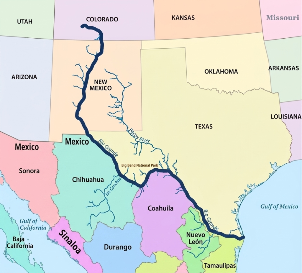
To understand its full journey, the river’s course is commonly divided into three major segments: the upper course, middle course, and lower course. Each section has distinct landscapes, climate conditions, and human uses that shape the river’s character.
Upper Course of the Rio Grande
In its upper course, the Rio Grande begins in the San Juan Mountains of the Rocky Mountains in southwestern Colorado. It originates within the Rio Grande National Forest as a high-altitude, snow-fed mountain stream. The river starts at an elevation of about 12,000 feet, where melting snow and spring-fed waters converge to form its early flow. This headwater region is located in San Juan County, Colorado, near approximately 37°47′ N latitude and 107°32′ W longitude, just east of the Continental Divide of the Americas.
At this early stage, the river is formed by the merging of several small streams at the base of Canby Mountain. The terrain is steep, cold, and heavily influenced by seasonal snowmelt, which controls the strength and volume of the river’s initial flow. As it moves southward into New Mexico, the Rio Grande begins to carve deep valleys and scenic canyons, including the famous Rio Grande Gorge near Taos. This upper section is characterized by dramatic elevation changes and fast-flowing water that gradually transitions into a broader river system.
Middle Course of the Rio Grande
The middle course of the Rio Grande begins as it flows through central New Mexico and continues toward the Texas border region. In this section, the river becomes more established and begins to play a major role in supporting agriculture, cities, and regional water systems. It passes through important urban centers such as Albuquerque and Las Cruces, where it provides essential water for municipal supply and irrigation.
As the river continues south, it approaches the region near El Paso, Texas, where it undergoes a significant geographic transition. Here, the Rio Grande turns southeast and begins forming the international boundary between the United States and Mexico. Along this stretch, it borders Mexican states including Chihuahua, Coahuila, Nuevo León, and Tamaulipas. The surrounding environment becomes increasingly arid, with desert landscapes, rugged terrain, and limited rainfall.
This middle course also includes dramatic natural features such as the canyon systems of Big Bend National Park, where the river winds through deep valleys and limestone cliffs. Despite the harsh environment, the river remains a vital water source. Its flow is strengthened by major tributaries such as the Pecos River in the United States and the Rio Conchos in Mexico, which help sustain water levels during seasonal fluctuations and dry periods.
Lower Course of the Rio Grande
In its lower course, the Rio Grande enters the Lower Rio Grande Valley, a region known for its warm climate and highly productive agricultural land. Here, the river slows significantly and spreads across flatter terrain, forming a wide and fertile corridor that supports intensive farming. This area is one of the most important agricultural zones in the region, relying heavily on the river for irrigation and water supply.
As the river approaches its final destination, it continues southeast until it reaches the Gulf of Mexico. The river eventually empties through a small delta system that has been greatly reduced over time due to water diversion and reduced natural flow. Even so, the lower course remains a critical ecological and economic zone, marking the final stage of the Rio Grande’s long journey from mountain headwaters to the sea.
Rio Grande Delta
The Rio Grande Delta represents the final stage of the Rio Grande, where the river eventually empties into the Gulf of Mexico after traveling nearly 1,900 miles from the Rocky Mountains of Colorado. This broad coastal region extends across southernmost Texas and northern Tamaulipas in Mexico, where the Rio Grande has formed a wide, lobate delta plain roughly 150 kilometers wide. More than just the river’s endpoint, the delta is a complex environmental and economic region that supports major cities, productive agricultural lands, and internationally important ecosystems.
The delta region has long been known for its fertile soils, extensive wetlands, and rich biodiversity. Over thousands of years, sediment carried downstream by the Rio Grande gradually accumulated near the river’s mouth, creating low-lying floodplains, marshes, and distributary channels. These natural processes formed a productive coastal environment that supported wildlife, fisheries, and agriculture. Historically, the delta was much larger and more active than it is today, with seasonal flooding helping maintain wetland ecosystems and replenish nutrient-rich soils.
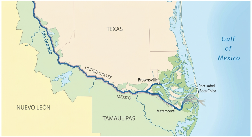
Geographically, the Rio Grande Delta is part of the broader Lower Rio Grande Valley, a warm sub-tropical region characterized by flat terrain, fertile farmland, and a relatively humid climate compared to the arid landscapes farther upstream. The river slows considerably in this lower section as it approaches the Gulf of Mexico, spreading across a wider floodplain before finally entering the sea through a narrow and sandy outlet.
One of the defining features of the delta region is its agricultural productivity. The combination of warm temperatures, fertile alluvial soils, and irrigation from the Rio Grande has transformed the Lower Rio Grande Valley into an important farming region. Crops such as citrus fruits, cotton, sugarcane, vegetables, and grains are widely cultivated throughout the area. Agriculture has become a major economic activity on both sides of the border, making the river’s water supply critically important for local communities and regional economies.
Beyond farming, the delta has also developed into a major bi-national economic hub. Metropolitan areas such as Brownsville and McAllen in Texas, along with Matamoros and Reynosa in Tamaulipas, play central roles in cross-border manufacturing, transportation, and international trade. The close economic connection between the United States and Mexico has transformed the region into an active industrial corridor where commerce, logistics, and population growth continue to expand rapidly.
One of the most distinctive ecological features of the delta is the Rio Grande Delta Thorn Woodland, a dense evergreen subtropical habitat found nowhere else in the United States. This thorny woodland ecosystem contains a mixture of drought-resistant shrubs, trees, and native vegetation adapted to the region’s warm climate and seasonal rainfall patterns. Although much of the original habitat has been cleared for agriculture and urban development, remaining patches continue to support diverse wildlife populations and rare plant species.
The delta also supports valuable ecosystems that provide habitat for numerous species of birds, fish, reptiles, and mammals. Because the region lies along major migratory bird routes, it serves as an important resting and feeding area for migratory species traveling between North and South America. Wetlands and riparian forests within the delta create ecological diversity that is relatively rare in the surrounding dry regions of the American Southwest and northern Mexico.
Despite its importance, the Rio Grande Delta has undergone significant environmental changes over the past century. Large-scale dam construction, irrigation projects, and water diversion upstream have drastically reduced the amount of freshwater reaching the delta. In many years, very little water from the Rio Grande actually reaches the Gulf of Mexico naturally. Reduced flow has caused wetland loss, increased salinity, habitat degradation, and shrinking coastal ecosystems that once depended on regular flooding and sediment deposits.
Urban development and agricultural expansion have also altered the natural landscape of the delta. Many original wetlands have been drained or converted into farmland and settlements, reducing biodiversity and disrupting natural ecological cycles. Climate change has added further pressure through rising temperatures, prolonged drought conditions, and the threat of sea-level rise along the Gulf Coast.
In response, conservation groups, environmental agencies, and regional planners on both sides of the border have worked to protect and restore portions of the delta ecosystem. Restoration projects focused on wetlands, thorn woodlands, and wildlife habitats aim to preserve the natural character of the region while balancing the growing demands of agriculture, cities, and industry.
Today, the Rio Grande Delta remains one of the most geographically unique and strategically important regions along the entire river system. It serves as a meeting point between river and ocean, nature and development, and the economies of two nations. Even though modern water management and urban expansion have transformed much of the original landscape, the delta continues to play a vital role in supporting biodiversity, agriculture, trade, and coastal life along the Gulf of Mexico.
Rio Grande Basin
The Rio Grande Basin is one of the largest and most geographically diverse river basins in North America. Covering more than 330,000 square miles (800,000 square kilometers), the basin stretches across the U.S. states of Colorado, New Mexico, and Texas, while also extending into the Mexican states of Chihuahua, Durango, Coahuila, Nuevo León, and Tamaulipas. The basin includes all the land areas drained by the Rio Grande and its tributaries, creating a vast watershed system that supports millions of people, major agricultural regions, industries, and ecosystems across two nations.
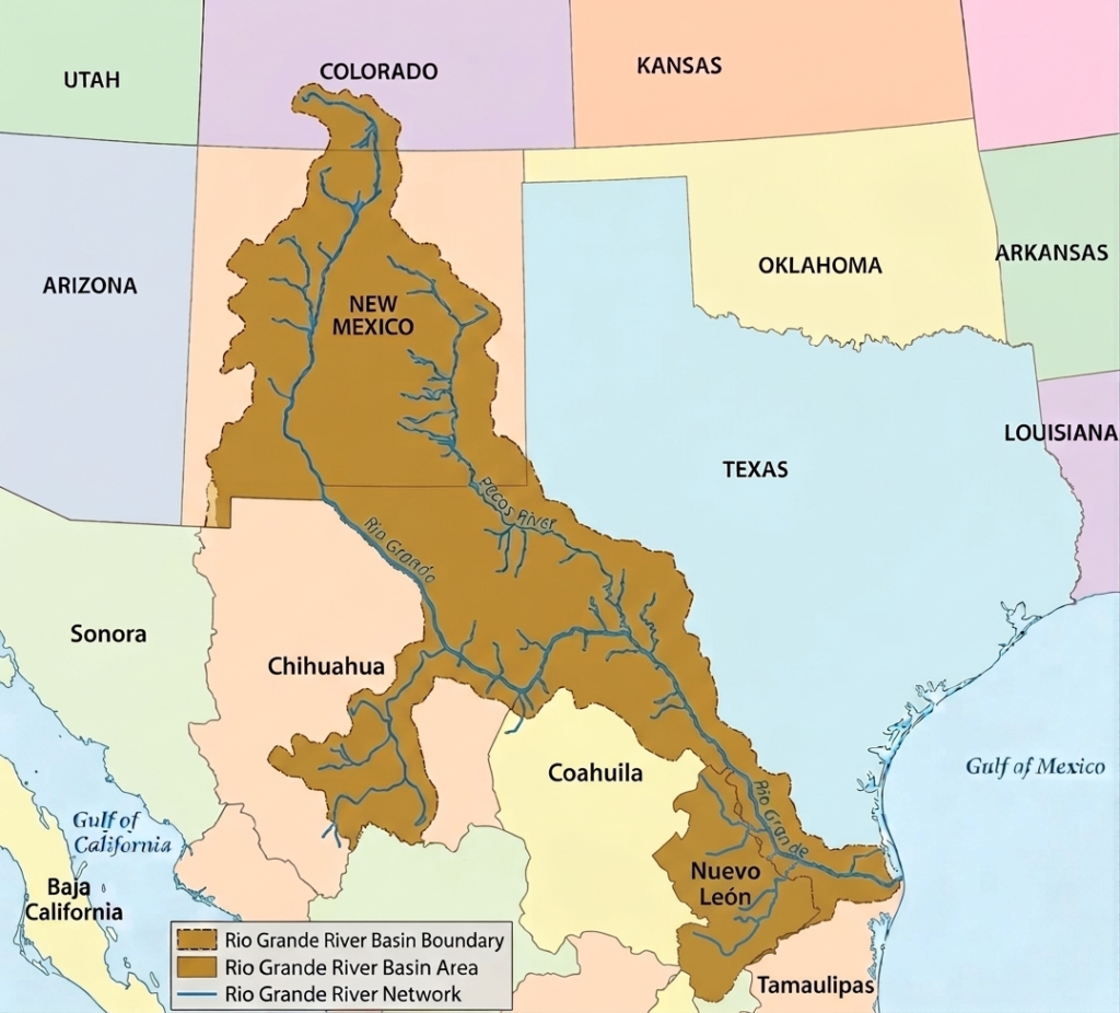
One of the defining characteristics of the Rio Grande Basin is its international significance. For approximately 1,254 miles of its journey, the Rio Grande forms the natural boundary between the United States and Mexico, making it one of the most important transboundary river systems in North America. Throughout this border region, the river serves as a critical source of drinking water, irrigation, industry, and ecological support for rapidly growing urban centers and rural communities alike.
In Texas alone, the Rio Grande Basin drains nearly 86,720 square miles of land. Because of the basin’s enormous size and the wide range of landscapes it covers, environmental conditions vary considerably from one region to another. Mountain headwaters, desert valleys, grasslands, reservoirs, wetlands, and coastal plains all form part of the broader watershed system. To better manage these differences, the basin is commonly divided into four major sections: the Upper Rio Grande Sub-Basin, the Middle Rio Grande Sub-Basin, the Lower Rio Grande Sub-Basin, and the Pecos River Basin.
Upper Rio Grande Basin
The Upper Rio Grande Basin begins at the Texas–New Mexico border and extends downstream to the International Amistad Reservoir. This section covers approximately 650 river miles and is characterized by semi-arid conditions, hot summers, limited rainfall, and long periods of intense sunshine. Water in this region is heavily used for agriculture and municipal supply, making irrigation and drinking water the dominant demands placed on the river system.
Because irrigation withdrawals are extensive in this section, water quality and water availability have become major concerns. Agricultural runoff, increasing salinity, and reduced river flow affect both environmental conditions and long-term water sustainability. Despite these challenges, the river remains essential to the communities and cities located within the basin.
This sub-basin includes major population centers such as El Paso, Texas, and Ciudad Juárez, Mexico, which together form one of the largest binational metropolitan regions along the border, with a combined population of several million residents. The region also includes communities such as Presidio and Ojinaga, as well as environmentally important areas like Big Bend National Park, where the river flows through dramatic desert canyons and rugged landscapes.
Middle Rio Grande Basin
The Middle Rio Grande Basin extends from the Amistad Reservoir downstream to Falcon Reservoir and covers approximately 303 river miles. This section of the basin continues through an arid environment where temperatures are frequently high and rainfall remains limited. Water from the river is widely used for agriculture, municipal supply, and industrial activities, making the basin economically important for both the United States and Mexico.
Urban development along this portion of the river has increased pressure on water resources and environmental quality. One of the most common concerns in the region is elevated bacteria levels in the water, which can affect public health and ecosystem conditions. Population growth and expanding infrastructure have made water management increasingly important throughout the basin.
Several major cross-border metropolitan areas are located within this sub-basin. The neighboring cities of Laredo, Texas, and Nuevo Laredo, Mexico, form a major commercial and transportation corridor, while Eagle Pass and Piedras Negras also serve as important border communities. Reservoir systems in this section, particularly Amistad and Falcon reservoirs, play essential roles in flood control, water storage, irrigation support, and hydroelectric power generation.
Lower Rio Grande Basin
The Lower Rio Grande Basin begins below Falcon Reservoir and continues downstream to the Gulf of Mexico, covering roughly 280 river miles. This region includes the Lower Rio Grande Valley, one of the most agriculturally productive areas along the U.S.-Mexico border. The climate ranges from arid to semi-arid, although it becomes warmer and slightly more humid closer to the Gulf Coast.
Communities throughout this sub-basin rely almost entirely on the Rio Grande for their water supply. Cities such as McAllen, Harlingen, and Brownsville in Texas depend heavily on the river for drinking water, irrigation, and economic activity. On the Mexican side, Reynosa and Matamoros are major urban centers with rapidly growing populations that also depend on the river system.
Agriculture remains one of the dominant industries in the lower basin, supported by fertile soils and extensive irrigation systems. However, this section faces several environmental challenges, including elevated salinity levels, bacterial contamination, and low dissolved oxygen in certain areas. Reduced freshwater flow and heavy water demand have intensified these issues over time, placing stress on ecosystems and water quality throughout the lower basin.
Pecos River Basin
The Pecos River is one of the most important tributaries within the Rio Grande Basin. Originating in the Sangre de Cristo Mountains of New Mexico, the river flows approximately 926 miles through New Mexico and Texas before joining the Rio Grande near the Amistad International Reservoir. Its waters contribute significantly to the overall flow of the Rio Grande system, particularly in the western Texas region.
Like much of the surrounding basin, the Pecos River region experiences predominantly arid to semi-arid climate conditions. Water from the Pecos is heavily utilized for irrigation and municipal purposes, especially in farming communities that depend on reliable access to freshwater. However, intensive water use and natural climatic conditions have contributed to environmental concerns such as high salinity and low dissolved oxygen levels.
Several communities and regional centers, including Pecos, Fort Stockton, and Monahans, are located within the Pecos River Basin. These towns rely on the river system for agriculture, economic activity, and local water supplies. Although the Pecos River flows through relatively dry and sparsely populated terrain, it remains a critical component of the larger Rio Grande watershed system.
Tributaries of the Rio Grande
The Rio Grande is sustained by an extensive network of tributaries that flow into the river from both the United States and Mexico. These tributaries play a critical role in maintaining water levels, supporting agriculture, replenishing ecosystems, and sustaining communities across the arid and semi-arid landscapes of the Rio Grande Basin. Because much of the basin experiences limited rainfall and high evaporation rates, tributary rivers and seasonal streams are essential for preserving the overall health and functionality of the river system.
Throughout its course, the Rio Grande receives water from mountain streams, spring-fed rivers, desert creeks, and major regional waterways. Some tributaries contribute consistent year-round flow, while others are highly seasonal and depend heavily on rainfall and monsoon activity. Together, they form a complex watershed network that supports both environmental systems and binational water supplies across the southwestern United States and northern Mexico.
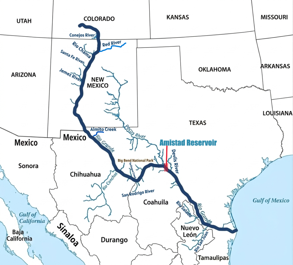
Major Tributaries of the Rio Grande in the United States
Several important tributaries join the Rio Grande from the United States side, particularly across Colorado, New Mexico, and Texas. These rivers provide essential freshwater to the Rio Grande system and help sustain agriculture, reservoirs, ecosystems, and growing urban populations throughout the basin. Many of these tributaries originate in mountainous regions where snowmelt and springs supply reliable flow to otherwise dry landscapes.
Pecos River
The Pecos River is the longest tributary of the Rio Grande and one of the most significant rivers in the basin. Extending approximately 926 miles, it begins in the Sangre de Cristo Mountains of New Mexico before flowing southward through eastern New Mexico and West Texas. The river eventually joins the Rio Grande within the Amistad National Recreation Area near the Amistad Reservoir.
The Pecos River is heavily used for irrigation, municipal water supply, and agricultural activities throughout its course. Because it flows through arid and semi-arid regions, water availability is extremely important for surrounding communities. However, portions of the river face environmental challenges such as elevated salinity and reduced flow caused by extensive water withdrawals and drought conditions.
Rio Chama
The Rio Chama is a 135-mile scenic tributary of the Rio Grande in northern New Mexico. Famous for its stunning multi-colored sandstone canyons and cliffs, it is a highly protected “Wild and Scenic” river renowned for wilderness rafting, fishing, and backcountry exploration.
It originates in the San Juan Mountains of southern Colorado and flows southward into north-central New Mexico, where it eventually merges with the Rio Grande.
Devils River
The Devils River is a spring-fed tributary located in southwestern Texas. Known for its pristine turquoise waters and rugged limestone canyons. Spanning roughly 94 miles, it flows through Val Verde County before emptying into the Amistad Reservoir.
Conejos River
The Conejos River is a 92.5-mile-long important tributary of the Rio Grande located within the San Luis Valley of southern Colorado. Originating in the San Juan Mountains, the river flows through agricultural valleys and high-elevation terrain before contributing water to the Rio Grande system.
Renowned as a premier fly-fishing destination, the river offers some of Colorado’s most spectacular mountain scenery, diverse trout populations, and rich ecological habitats.
Red River
The Red River of New Mexico is a 68-mile perennial tributary that flows down from the Sangre de Cristo Mountains into the Rio Grande. The lower 4 miles of the Red River cut through the spectacular 800-foot deep gorge of the Rio Grande del Norte National Monument in northern New Mexico.
Jemez River
The Jemez River is a picturesque 50-mile waterway in Sandoval County, New Mexico, renowned for its exceptional cold-water fishing, dramatic red rock canyons, and geothermal activity. It is formed by the confluence of the East Fork Jemez River and San Antonio Creek within the Jemez Mountains before flowing south into the Rio Grande near Bernalillo.
Santa Fe River
The Santa Fe River is a 46-mile-long tributary of the Rio Grande in northern New Mexico. Originating in the Sangre de Cristo Mountains, it flows through downtown Santa Fe before draining into the Rio Grande at the Cochiti Reservoir.
Alamito Creek
Alamito Creek is an 82-mile-long intermittent stream in West Texas. Rising north of Marfa in Presidio County, it flows southwest through the Chihuahuan Desert before emptying into the Rio Grande just southeast of Presidio. It features vital desert riparian habitats and conservation initiatives.
Terlingua Creek
Terlingua Creek is an 83-mile-long desert stream located in Brewster County, Texas, flowing through Big Bend National Park before emptying into the Rio Grande. Its mouth sits right at the entrance of the famous Santa Elena Canyon. As a classic “desert stream,” its water levels vary heavily; it can be completely dry for months or instantly turn into a rushing torrent after heavy flash floods.
Major Tributaries of the Rio Grande in Mexico
Several major tributaries from Mexico contribute significantly to the flow and sustainability of the Rio Grande. These rivers drain large portions of northern Mexico and play a critical role in supporting agriculture, reservoir systems, urban development, and ecological habitats throughout the basin. In many cases, Mexican tributaries provide essential water to the lower Rio Grande, especially during dry seasons when river flow is reduced.
Rio Conchos
The Río Conchos is a 350-mile tributary of the Rio Grande and the most important river system in Chihuahua, Mexico. Rising in the Sierra Madre Occidental, it flows northeast through the Chihuahuan Desert before joining the Rio Grande at Ojinaga, opposite Presidio, Texas.
The river supports major agricultural areas and cities including Camargo, Delicias, and Ojinaga. It also contains important reservoirs and hydroelectric projects such as Boquilla Dam, the largest dam in Chihuahua.
Rio Salado
The Salado River rises in the Sierra Madre Oriental in Coahuila and flows east-northeastward through northern Mexico before joining the Rio Grande at Falcón International Reservoir opposite Zapata, Texas. It drains large areas of Coahuila and parts of Nuevo León, collecting runoff from dry plains and seasonal streams before contributing to the Rio Grande watershed.
Rio San Juan
The Río San Juan is the largest and most important river system in Nuevo León, Mexico, with a drainage basin covering about 33,538 square kilometers. Originating in southeastern Coahuila, it flows eastward through Coahuila, Nuevo León, and Tamaulipas before joining the Rio Grande near Camargo, Tamaulipas. The river is economically important because it supplies water to El Cuchillo Dam, a major freshwater source for the city of Monterrey.
San Rodrigo River
The San Rodrigo River (Río San Rodrigo) is a stream in Coahuila, Mexico. It originates in the Chihuahua Desert and serves as a major tributary to the Rio Grande. It empties into the main channel near El Moral, Mexico, and Quemado, Texas.
Rio Alamo
The Río Álamo is an important tributary of the Rio Grande in Tamaulipas, Mexico. It drains a watershed of about 1,675 square miles and joins the Rio Grande near Ciudad Mier, around 12 miles downstream from Falcon Dam. The river is part of northeastern Mexico’s water management system and includes Las Blancas Dam, which diverts water toward the Marte R. Gómez Reservoir for agricultural irrigation and municipal storage.
Arroyo Las Vacas
The Arroyo Las Vacas This is a prominent and legally significant tributary of the Rio Grande located near Ciudad Acuña in Coahuila, Mexico. It flows into the Amistad Reservoir region along the Texas border and plays an important role in binational water management between the United States and Mexico.
Frequently Asked Questions about Rio Grande
What is the Rio Grande?
The Rio Grande is one of the longest and most important rivers in North America. It flows from the Rocky Mountains in Colorado to the Gulf of Mexico and forms approximately 1,254 miles (2,018 kilometers) of the international border between the United States and Mexico.
Where is the Rio Grande located?
The Rio Grande flows through the U.S. states of Colorado, New Mexico, and Texas while also bordering the Mexican states of Chihuahua, Coahuila, Nuevo León, and Tamaulipas.
Where does the Rio Grande start and end?
The Rio Grande begins in the San Juan Mountains of southern Colorado within the Rocky Mountains and travels southward before emptying into the Gulf of Mexico near Brownsville, Texas, and Matamoros, Mexico.
How long is the Rio Grande River?
The Rio Grande is approximately 1,900 miles (3,060 kilometers) long, making it one of the major river systems in North America.
Why is the Rio Grande so famous?
The Rio Grande is famous for forming a large section of the U.S.–Mexico border, supporting agriculture and cities across the Southwest, and flowing through well-known landscapes such as Big Bend National Park and the Rio Grande Gorge.
Why do Americans call it “Rio Grande”?
The name “Rio Grande” comes from Spanish and means “Big River.” Spanish explorers used the term to describe the river’s size and regional importance during the colonial period.
What animals live in the Rio Grande?
The Rio Grande supports diverse wildlife including fish, birds, mammals, reptiles, and butterflies. Species commonly found along the river include catfish, river otters, turtles, pelicans, green jays, beavers, and migratory birds.
Are there snakes in the Rio Grande?
Yes. Several snake species live near the Rio Grande, including water snakes, garter snakes, and some venomous desert species found in parts of Texas and New Mexico.
Are there alligators in the Rio Grande?
Yes. American alligators can occasionally be found in wetlands and marshes near the Lower Rio Grande Valley and Gulf Coast region. They are uncommon in most parts of the river and are mainly limited to warmer southern habitats.
Are crocodiles in the Rio Grande?
No. Crocodiles are not native to the Rio Grande. The river’s ecosystems do not naturally support crocodile populations.
Is it safe to swim in the Rio Grande?
Swimming conditions vary depending on the location. Some sections of the river contain strong currents, deep water, pollution concerns, or rugged terrain, so visitors should always follow local safety advisories before entering the water.
Is the Rio Grande drying up?
Parts of the Rio Grande experience declining water levels because of drought, climate change, dams, and heavy agricultural water use. During severe drought periods, some stretches of the river may become shallow or temporarily dry.