The Mississippi River is the second-longest river in North America, flowing approximately 2,340 miles from Lake Itasca in Minnesota to the Gulf of Mexico in Louisiana. It drains 41% of the contiguous United States, stretching from the Appalachian Mountains to the Rocky Mountains, and reaching into parts of 31 U.S. states and 2 Canadian provinces.
Mississippi River is a vital commercial waterway transporting over 460 million tons of cargo annually, including agricultural exports, steel, and coal.
Table of Contents
Origin of Mississippi River
- The Mississippi River officially originates from Lake Itasca, a small glacial lake located in northern Minnesota.
- Lake Itasca is situated within Itasca State Park in Clearwater County, Minnesota.
- Situated at approximately 1,475 feet above sea level, this small glacial lake serves as the headwaters, where water flows over a rocky weir, initiating the 2,340-mile journey to the Gulf of Mexico.
- Lake Itasca is a glacial lake formed thousands of years ago during the last Ice Age. Smaller streams, springs, and surrounding wetlands continuously feed the lake, helping maintain the steady flow of water that begins the long journey of the Mississippi River.

Course of Mississippi River
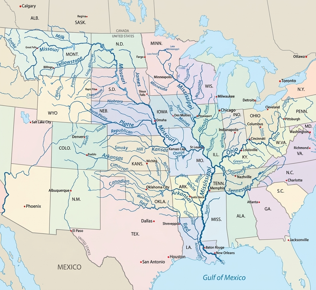
The Mississippi River flows approximately 2,340 miles (3,766 km) south from its source at Lake Itasca in Minnesota to the Gulf of Mexico. The river flows through 10 U.S. states—Minnesota, Wisconsin, Iowa, Illinois, Missouri, Kentucky, Tennessee, Arkansas, Mississippi, and Louisiana—before finally forming a massive delta at the Gulf of Mexico.
The Mississippi River Basin drains 31 U.S. states and 2 Canadian provinces, forming one of the largest watershed systems in the world.
It is categorized into three sections: the Upper Mississippi (headwaters to Missouri River), Middle Mississippi (to Ohio River), and Lower Mississippi (to Gulf of Mexico).
1. Upper Mississippi (Headwaters to Missouri River)
The Upper Mississippi River, stretching approximately 1,200+ miles from its headwaters at Lake Itasca, Minnesota, to its confluence with the Missouri River near St. Louis, serves as a vital ecological and industrial corridor.
This section begins as a clear, winding stream in the headwaters. It is characterized by steep limestone bluffs and a narrower floodplain compared to the lower sections.
As the river flows southward through Minnesota and Wisconsin, it passes through several lakes and reservoirs before reaching major urban centers such as Minneapolis and Saint Paul. At Saint Anthony Falls in Minneapolis, the river historically featured the only major natural waterfall along its entire course. This location later became an important industrial center because the water flow powered flour mills and manufacturing industries during the 19th century.
The upper river region contains 29 locks and dams (mostly south of Minneapolis) designed to regulate water levels for commercial navigation.
This section also home to the Upper Mississippi River National Wildlife and Fish Refuge, which supports diverse fish, mussels, and migratory birds along the Mississippi Flyway. Recreation such as boating, fishing, hiking, and river tourism is especially important in the upper Mississippi Valley.
2. Middle Mississippi (Missouri River to Ohio River)
The Middle Mississippi River is a nearly 190–200 mile section of the Mississippi River that extends from the confluence with the Missouri River near St. Louis to the meeting point with the Ohio River at Cairo. This stretch forms an important transportation, ecological, and flood-control corridor in the central United States.
After the Mississippi merges with the Missouri River near St. Louis, the river becomes significantly larger, deeper, and more powerful. The Missouri River contributes enormous amounts of sediment, giving the Mississippi its characteristic muddy appearance and increasing turbulence within the channel. Unlike the Upper Mississippi, this section is relatively free-flowing because it contains no locks or dams.
The river flows southward through broad floodplains and fertile agricultural landscapes while separating Missouri to the west from Illinois to the east. Over this section, the river drops approximately 220 feet, averaging about 1.2 feet per mile. Large sandbars, islands, side channels, wetlands, and floodplain forests dominate the landscape, creating diverse ecosystems that support wildlife and migratory bird habitats.
Major tributaries such as the Illinois, Arkansas, and Ohio rivers further strengthen the Mississippi River system and contribute enormous water volume. Important cities including St. Louis and Memphis developed along this section because of the river’s importance for transportation, shipping, and commerce. During the 19th century, steamboats transported cotton, timber, grain, and manufactured goods through this corridor, while today commercial barges continue carrying agricultural and industrial products along the river.
The Middle Mississippi River also holds major historical importance because it played a crucial role during westward expansion and the American Civil War. Control of the river was strategically important for military operations, trade routes, and communication between northern and southern states.
Ecologically, the region supports wetlands, floodplain forests, islands, and backwater habitats that are important for fish, mussels, bald eagles, pelicans, and migratory birds along the Mississippi Flyway. The Middle Mississippi River National Wildlife Refuge was established in 2000 to protect floodplain habitats and restore ecosystems damaged by major floods, including the devastating 1993 Mississippi River flood.
Today, the Middle Mississippi remains one of the most heavily used commercial waterways in North America. Levees and flood-control systems help manage flooding and maintain navigation, although industrial activity and floodplain modification continue to create environmental challenges. Recreational activities such as fishing, boating, birdwatching, and wildlife observation are also popular throughout the region.
3. Lower Mississippi (Ohio River to Gulf of Mexico)
The Lower Mississippi River is the final and largest section of the Mississippi River, extending for nearly 1,000 miles from the confluence with the Ohio River near Cairo to its mouth at the Gulf of Mexico near New Orleans. This section flows through or borders the states of Illinois, Kentucky, Missouri, Tennessee, Arkansas, Mississippi, and Louisiana, forming one of the most important economic and ecological corridors in North America.
After the Ohio River joins the Mississippi at Cairo, the river reaches its maximum size, depth, and discharge volume. The Lower Mississippi becomes a classic meandering alluvial river characterized by wide, deep, and relatively slow-moving waters that can span more than 1.5 miles from bank to bank in certain areas. Over thousands of years, the river deposited massive amounts of sediment across the valley, creating broad floodplains, natural levees, wetlands, oxbow lakes, and fertile agricultural land.
Unlike the Upper Mississippi River, the Lower Mississippi contains no locks or dams, making it one of the world’s most important uninterrupted commercial navigation routes. The river is heavily maintained through levees, floodways, spillways, revetments, and channel improvements managed largely by the United States Army Corps of Engineers. These engineering systems help reduce flood risks, maintain shipping channels, and protect nearby communities and farmland from seasonal flooding.
The Lower Mississippi River forms the center of the world’s largest port system in terms of cargo tonnage. Ports along this section handle enormous quantities of grain, petroleum, chemicals, coal, steel, and agricultural products that move between the American Midwest and international markets. Major cities such as Memphis, Baton Rouge, and New Orleans developed into major trade and transportation hubs because of their strategic river locations.
The fertile alluvial soil deposited by repeated flooding has also made the Lower Mississippi Valley one of the most productive agricultural regions in the United States. Crops such as cotton, soybeans, rice, corn, and sugarcane are extensively cultivated throughout the floodplain, supporting regional and national agricultural economies.
Ecologically, the Lower Mississippi River and the Lower Mississippi Alluvial Valley cover more than 24 million acres and contain some of the most important wetland and floodplain ecosystems in North America. The region includes major portions of the Mississippi Flyway, which supports over 40% of North America’s migratory waterfowl and around 60% of all U.S. bird species. The valley also contains nearly 40% of the estuarine wetlands found in the contiguous United States.
As the river approaches Louisiana and the Gulf Coast, it begins dividing into distributaries that form the Mississippi River Delta. These wetlands and marshes play a critical role in fisheries, wildlife habitats, coastal protection, and storm buffering during hurricanes and tropical storms.
Despite its economic and ecological importance, the Lower Mississippi River faces several modern environmental challenges. Low water levels during dry seasons can disrupt barge traffic and commercial navigation, while excessive sediment, fertilizers, pesticides, and industrial pollutants continue to affect water quality and ecosystem health. Coastal erosion and wetland loss near the delta also remain major concerns.
Organizations such as the United States Geological Survey and other environmental agencies continuously monitor water quality, river discharge, sediment transport, and ecosystem conditions throughout the Lower Mississippi-Gulf region to balance economic activity with long-term environmental sustainability.
Mississippi River Delta | Mouth of Mississippi River
The Mississippi River Delta is a vast coastal region in southeastern Louisiana where the Mississippi River reaches the Gulf of Mexico. Covering nearly 3 million acres, it forms one of the largest wetland systems in the United States and represents the final stage of the river’s 2,340-mile journey across North America.
The delta extends from Vermilion Bay in western Louisiana to the Chandeleur Islands in the east, with much of the region centered around Plaquemines Parish south of New Orleans. The Mississippi River divides into distributaries in this region, creating the famous “bird’s foot” pattern of the Plaquemines-Balize Delta. This landform developed through centuries of sediment deposition, mainly over the last 500–600 years, as the river carried enormous amounts of silt, clay, and sand from across its vast drainage basin.

Geographically, the Mississippi River Delta consists of marshes, swamps, mudflats, distributary channels, barrier islands, estuaries, and coastal wetlands. The river slows significantly near the Gulf Coast, causing sediment to settle and gradually build new land. This continuous process historically helped shape much of Louisiana’s coastline.
The delta is ecologically one of the most important regions in North America. It contains nearly 37% of the estuarine marsh found in the contiguous United States and supports highly diverse ecosystems, including freshwater marshes, brackish wetlands, cypress forests, and coastal bays. The region serves as a critical habitat for fish, shrimp, oysters, crabs, alligators, and migratory birds.
The Mississippi Flyway passes directly through the delta, making it one of the most important migratory bird regions on the continent. Approximately 70% of North America’s migratory waterfowl use this corridor during seasonal migration, while numerous bird species rely on the wetlands for nesting, feeding, and wintering habitats.
Economically, the Mississippi River Delta is one of the most important commercial regions in the United States. The delta supports one of the world’s busiest port systems, connecting inland North America to global shipping routes through the Gulf of Mexico. Major ports near New Orleans and southern Louisiana handle grain exports, petroleum products, chemicals, steel, and industrial cargo.
The delta also supports major commercial fisheries and offshore energy industries. Louisiana’s coastal waters are among the most productive fishing grounds in the country, supplying shrimp, oysters, crab, and seafood products to national and international markets.
In addition to its economic importance, the delta provides critical storm protection for coastal Louisiana. Wetlands and marshes act as natural buffers by absorbing storm surges, slowing floodwaters, and reducing the impact of hurricanes moving inland from the Gulf Coast.
However, the Mississippi River Delta faces a severe environmental crisis due to rapid land loss and coastal erosion. Louisiana has lost an area of coastal land roughly the size of Delaware over the past century. Human engineering projects, especially levee construction along the Mississippi River, have prevented the natural flow of sediment into wetlands that once rebuilt the delta naturally.
Other factors contributing to land loss include canal dredging, hurricanes, sea-level rise, saltwater intrusion, subsidence, and reduced sediment deposition. Pollution and nutrient runoff carried by the Mississippi River have also affected water quality and ecosystem health throughout the delta region.
To address these challenges, large-scale restoration efforts are underway across coastal Louisiana. Restoration projects focus on sediment diversion systems designed to reconnect the river with nearby wetlands, rebuild marshes, restore barrier islands, and balance ecological sustainability with commercial navigation and flood protection. These efforts are considered essential for preserving the future of the Mississippi River Delta and the communities, industries, and ecosystems that depend on it.
Tributaries of Mississippi River
The Mississippi River is fed by an enormous network of more than 250 tributaries that together form one of the largest river systems in the world. The Mississippi River Basin, also known as the Mississippi/Atchafalaya River Basin (MARB), drains approximately 1.26 million square miles and covers nearly 41% of the contiguous United States. This vast watershed collects water from 31 U.S. states and parts of Canada, making it the third-largest drainage basin in the world.
The tributaries of the Mississippi River originate from diverse landscapes including the Rocky Mountains, Appalachian Mountains, Great Plains, forests, wetlands, and agricultural regions. These rivers supply enormous quantities of water, sediment, nutrients, and minerals to the Mississippi system, supporting transportation, agriculture, ecosystems, hydroelectric power, fisheries, and commercial navigation throughout the United States.
Tributaries entering from the eastern side of the river are known as left-bank tributaries, while those entering from the western side are called right-bank tributaries. Major left-bank tributaries include the Ohio River, Illinois River, and Wisconsin River, while the Missouri River, Arkansas River, and Red River are major right-bank tributaries.
Left-Bank Tributaries of the Mississippi River
The left-bank tributaries of the Mississippi River are rivers that join the Mississippi from the eastern side while facing downstream toward the Gulf of Mexico. These tributaries mainly drain the eastern and northeastern parts of the Mississippi River Basin and contribute enormous amounts of water, sediment, and nutrients to the river system.
1. Ohio River
The Ohio River is the largest left-bank tributary by water volume and one of the most important rivers in the Mississippi Basin. It joins the Mississippi River near Cairo and significantly increases the river’s size, depth, and discharge. Originating at Pittsburgh, Pennsylvania, the Ohio River drains large parts of the eastern United States and serves as a major transportation and industrial corridor.
2. Illinois River
The Illinois River flows across Illinois before joining the Mississippi River near Grafton, Illinois. It is economically important because it connects the Mississippi River system to the Great Lakes through the Illinois Waterway, making it a vital inland shipping route for commercial trade and transportation.
3. Wisconsin River
The Wisconsin River is a major left-bank tributary of the Upper Mississippi River. Originating in northern Wisconsin, the river flows through forests, sandstone valleys, and agricultural regions before joining the Mississippi near Prairie du Chien, Wisconsin.
4. Tennessee River
The Tennessee River is a major tributary of the Ohio River system, which ultimately contributes water to the Mississippi River. Flowing through Tennessee, Alabama, Kentucky, and Mississippi, the river is important for hydroelectric power generation, flood control, navigation, and industrial development.
5. Wabash River
The Wabash River flows through Indiana and Illinois before joining the Ohio River watershed. It supports agriculture, transportation, and regional ecosystems while contributing water and sediment to the larger Mississippi River Basin.
Together, these left-bank tributaries play a major role in maintaining the water flow, navigation system, agricultural productivity, and ecological diversity of the Mississippi River system.
Right-Bank Tributaries of the Mississippi River
The right-bank tributaries of the Mississippi River are rivers that join the Mississippi from the western side while facing downstream toward the Gulf of Mexico. These tributaries mainly drain the Rocky Mountains, Great Plains, and central western regions of the United States, contributing large amounts of water, sediment, and nutrients to the Mississippi River system.
1. Missouri River
The Missouri River is the longest and one of the most important right-bank tributaries of the Mississippi River. Originating in the Rocky Mountains of Montana, it flows for more than 2,300 miles before joining the Mississippi near St. Louis. The Missouri River contributes enormous sediment loads, which give the Mississippi its characteristic muddy appearance and greatly increase its discharge volume.
2. Arkansas River
The Arkansas River begins in the Rocky Mountains of Colorado and flows through Kansas, Oklahoma, and Arkansas before joining the Mississippi River. It is an important waterway for irrigation, agriculture, transportation, and regional water supply across the southern Great Plains.
3. Red River
The Red River is a major southern tributary flowing through Texas, Oklahoma, Arkansas, and Louisiana before connecting with the Mississippi River system. The river supports agriculture, floodplain ecosystems, fisheries, and regional water management in the southern United States.
4. Minnesota River
The Minnesota River joins the Mississippi River near Saint Paul and serves as one of the primary tributaries in the upper Mississippi region. It drains agricultural lands across southern Minnesota and contributes water, sediment, and nutrients to the upper basin.
5. White River
The White River flows through Arkansas and Missouri before joining the Mississippi River system. The river is known for its reservoirs, fisheries, recreation, and hydroelectric projects that support tourism and water management in the southern Mississippi Basin.
6. Atchafalaya River
The Atchafalaya River is a major distributary connected to the Mississippi River system in Louisiana. It diverts substantial amounts of water from both the Mississippi and Red rivers toward the Gulf of Mexico. The Atchafalaya Basin forms one of the largest swamp and wetland systems in the United States and plays a major role in flood control, fisheries, and wetland ecology.
Together, these right-bank tributaries contribute significantly to the Mississippi River’s water volume, sediment transport, navigation system, agricultural productivity, and ecological diversity across much of the United States.
Frequently Asked Questions About the Mississippi River
Q. Where does the Mississippi River start and end?
The Mississippi River officially begins at Lake Itasca in northern Minnesota and flows southward before emptying into the Gulf of Mexico through the Mississippi River Delta in Louisiana.
Q. Where does the Mississippi River start and end?
The Mississippi River officially begins at Lake Itasca in northern Minnesota and flows southward before emptying into the Gulf of Mexico through the Mississippi River Delta in Louisiana.
Q. In what state does the Mississippi River begin?
The Mississippi River begins in the U.S. state of Minnesota at Lake Itasca, which is located inside Itasca State Park.
Q. Mississippi River in which country?
The Mississippi River is located entirely within the United States and flows through or along ten U.S. states.
Q. How deep is the Mississippi River?
The depth of the Mississippi River varies greatly along its course, ranging from about 3 feet deep near Lake Itasca to more than 200 feet at its deepest point near Algiers Point in New Orleans, Louisiana.
Q. How long is the Mississippi River?
The Mississippi River is generally cited as being approximately 2,340 to 2,350 miles (3,766 to 3,782 kilometers) long, making it the second-longest river in North America.
Q. Is the Mississippi River the longest river in the world?
No, the Mississippi River is not the longest river in the world. Rivers such as the Nile River and Amazon River are longer, although the combined Mississippi-Missouri river system is among the world’s longest river systems.
Q. What are 5 facts about the Mississippi River?
The Mississippi River begins at Lake Itasca in Minnesota and ends at the Gulf of Mexico. It is over 2,340 miles long, drains nearly 40% of the contiguous United States, supports one of the world’s busiest inland shipping systems, and serves as a major migratory route known as the Mississippi Flyway.
Q. Why is the Mississippi River famous and important?
The Mississippi River is famous for its major role in American history, transportation, agriculture, trade, music, and culture. It is important because it supports commercial shipping, provides drinking water to millions of people, supports wildlife habitats, and connects the Midwest to international trade routes through the Gulf of Mexico.