The Ohio River is one of the most important waterways in the eastern United States, stretching 981 miles (1,579 km) from Pittsburgh, Pennsylvania, to Cairo, Illinois. It begins where the Allegheny and Monongahela rivers meet and flows generally southwest before joining the Mississippi River. Along its course, the Ohio River forms state boundaries, passes major cities such as Cincinnati and Louisville, and connects communities across the Midwest and Appalachian region.
The river has played a major role in American history, supporting trade, westward migration, industry, and agricultural development. Today, its network of tributaries drains a vast watershed, while locks and dams help maintain navigation along the river. Understanding the Ohio River map, its origin, route, mouth, tributaries, and basin reveals how this major river connects six states and contributes to the larger Mississippi River system.
Table of Contents
Ohio River Map
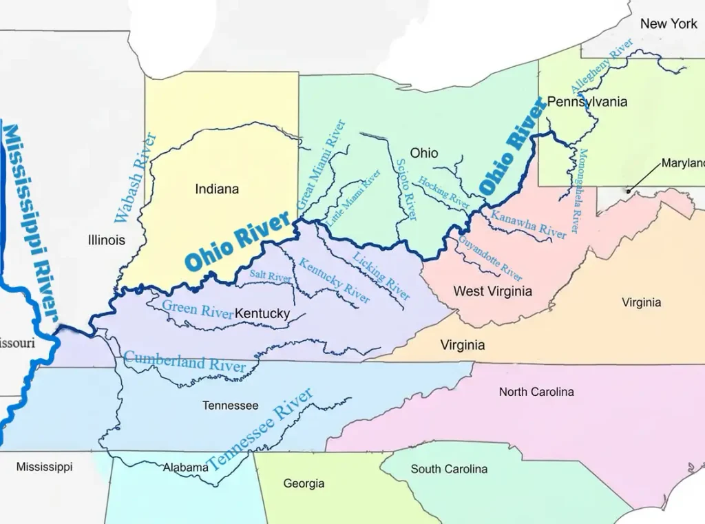
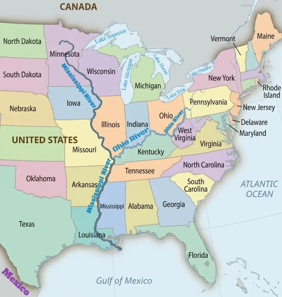
The Ohio River map with states shows the river’s 981-mile route from Pittsburgh, Pennsylvania, to Cairo, Illinois. Along the way, the river forms boundaries between several states and passes major cities such as Cincinnati, Louisville, and Evansville. At Cairo, the Ohio River joins the Mississippi River, connecting the Ohio Valley with the larger Mississippi River system.
Origin of Ohio River
The Ohio River originates at Point State Park in Pittsburgh, Pennsylvania, where the Allegheny and Monongahela rivers meet. This confluence, historically known as “The Point” or the “Three Rivers” area, marks the beginning of the Ohio River’s main channel. From here, the river flows westward and southwestward across the eastern and midwestern United States before reaching the Mississippi River at Cairo, Illinois.
The two rivers that form the Ohio River flow toward Pittsburgh from different directions. The Allegheny River flows south from western New York and Pennsylvania, while the Monongahela River flows north from northern West Virginia and southwestern Pennsylvania. Their meeting creates a single, larger waterway that carries water from an extensive upstream drainage network into the Ohio River basin.
The name Ohio is commonly traced to the Seneca word Ohi:yo’, often translated as “good river” or “great river.” The river became an important geographic route for Indigenous peoples and later European settlers, traders, and migrants moving through the interior of North America. Its location at the junction of the Allegheny and Monongahela rivers also helped Pittsburgh develop as a major transportation and industrial center.
Ohio River Route and Course
The Ohio River route extends 981 miles (1,579 km) from Pittsburgh, Pennsylvania, to Cairo, Illinois, where the river joins the Mississippi River. From its starting point, it follows a generally westward and southwestward course through the eastern and midwestern United States. Along the way, it forms parts of the boundaries between several states and passes major river cities, including Wheeling, Cincinnati, Louisville, Evansville, and Owensboro. Its route connects communities across the Ohio Valley and provides a major navigation corridor into the Mississippi River system.
Pennsylvania: The Starting Point
The Ohio River begins at Pittsburgh, Pennsylvania, where the Allegheny and Monongahela rivers meet. After forming at this confluence, it flows northwest for a short distance before turning westward. Pittsburgh developed at this strategic meeting point of waterways, which connected the Ohio River system with routes extending north through the Allegheny River and south through the Monongahela River. Pennsylvania is the river’s starting state; most of the remaining route forms state boundaries rather than passing through the interior of each state.
Ohio and West Virginia
After leaving Pennsylvania, the Ohio River flows southwest and forms much of the boundary between Ohio on its northern side and West Virginia on its southern side. Wheeling, West Virginia, lies along this stretch and became an important river and transportation center. Farther downstream, the river passes the area near Marietta, Ohio, one of the early settlements established along the Ohio River Valley. This section links communities on both banks while serving as a natural boundary between the two states.
Ohio and Kentucky
Farther west, the Ohio River forms a long boundary between southern Ohio and northern Kentucky. Cincinnati, Ohio, is one of the major cities along this stretch and developed into an important commercial center because of its position on the river. Downstream, the river reaches Louisville, Kentucky, where the historic Falls of the Ohio created a natural obstacle to navigation. Today, vessels can pass this area through the McAlpine Locks and Dam. The river continues to serve as a dividing line between communities in Ohio and Kentucky along this part of its route.
Indiana and Kentucky
Continuing westward, the Ohio River forms much of the boundary between southern Indiana and northern Kentucky. Evansville, Indiana, is a major city on the northern bank, while Owensboro, Kentucky, lies on the southern bank farther downstream. Ports and river facilities in this stretch support commercial navigation and connect local economies with the wider Ohio and Mississippi river networks. The river’s position along the state line has also shaped transportation links and settlement patterns on both sides.
Illinois and the Mississippi River
Near the end of its course, the Ohio River forms part of the boundary between Illinois to the north and Kentucky to the south. It reaches Cairo, Illinois, near the southern tip of the state, where it empties into the Mississippi River. This confluence brings the Ohio’s flow into the Mississippi system, which carries the combined waters south toward the Gulf of Mexico. The junction has long been geographically and historically important because it connects the Ohio Valley with one of the major north–south waterways of North America.
Mouth of Ohio River and Ohio River Delta
The mouth of the Ohio River is located near Cairo, Illinois, where the river joins the Mississippi River. After flowing 981 miles (1,579 km) from Pittsburgh, Pennsylvania, the Ohio reaches this junction and contributes its water to the Mississippi, which continues south toward the Gulf of Mexico. This confluence connects the Ohio River Valley with the larger Mississippi River drainage system and has long been important for river transportation and commerce.
The Ohio River is the largest tributary of the Mississippi River by discharge volume. At the confluence, the two rivers may appear different in color because they carry varying amounts of sediment, depending on rainfall and conditions across their watersheds. The meeting point lies just south of Cairo, where the surrounding landscape has been shaped by the movement of both rivers, flooding, and changes to their channels over time.
The Ohio River does not form a separate, prominent delta at its mouth. Instead, it empties into the Mississippi River as a tributary. A river delta generally develops where sediment accumulates at a river’s mouth, often where the river enters a lake or sea. The well-known Mississippi River Delta lies much farther downstream, where the Mississippi reaches the Gulf of Mexico. Therefore, when looking for the Ohio River delta on a map, the key geographic feature to identify is the Ohio–Mississippi confluence near Cairo, Illinois.
Tributaries of Ohio River
The Ohio River receives water from numerous tributaries that drain large parts of the eastern and midwestern United States. These rivers carry runoff from the Appalachian region, the central lowlands, and surrounding watersheds into the Ohio River, contributing to its flow before it joins the Mississippi River. Tributaries are commonly grouped into left-bank and right-bank tributaries, based on the banks seen while facing downstream toward the Mississippi River. The left bank is generally on the southern side of the Ohio River, while the right bank is generally on the northern side.
Left-Bank Tributaries of the Ohio River
The left-bank tributaries of the Ohio River enter from its southern side when facing downstream toward the Mississippi River. Many drain the Appalachian highlands and the states of West Virginia, Kentucky, and Tennessee. Arranged approximately from upstream to downstream, these rivers show how water from the Appalachian region and the American South enters the Ohio River along its course.
- Little Kanawha River: The Little Kanawha River is approximately 160 miles long and drains about 2,320 square miles of central West Virginia. It flows generally northwest through the Appalachian Plateau, passing communities such as Glenville and Elizabeth before reaching Parkersburg, where it joins the Ohio River. Its watershed includes forested hills, valleys, and communities shaped by the region’s natural resources. The river contributes to the flow of the upper Ohio River and forms part of West Virginia’s wider river network.
- Kanawha River: The Kanawha River’s main stem is approximately 97 miles long and drains about 12,200 square miles. It begins at Gauley Bridge, West Virginia, where the New and Gauley rivers meet, and flows northwest through the Kanawha Valley, passing Charleston and Montgomery. It joins the Ohio River at Point Pleasant, West Virginia. Although the Kanawha’s main channel is relatively short, its watershed extends across a much larger area through the New River system. The river valley is an important industrial and transportation corridor in West Virginia.
- Guyandotte River: The Guyandotte River is approximately 166 miles long and drains about 1,670 square miles of southern West Virginia. It flows northwest through the Appalachian Plateau, passing communities in the state’s coalfield region before reaching the Ohio River at Huntington, West Virginia. Its tributaries drain steep hillsides and narrow valleys, carrying runoff from the surrounding highlands into the Ohio River. The river is an important part of the drainage network in southern West Virginia.
- Big Sandy River: The Big Sandy River’s main stem is approximately 27 miles long and drains about 4,280 square miles through its wider watershed. It forms near Louisa, Kentucky, where the Levisa Fork and Tug Fork meet, and then follows part of the Kentucky–West Virginia border before joining the Ohio River at Catlettsburg, Kentucky. Its drainage basin extends into Kentucky, West Virginia, and Virginia. Although the main stem is short, the combined river system drains a substantial area of the central Appalachians and has historically provided a transportation corridor for communities in the region.
- Licking River: The Licking River is approximately 320 miles long and drains about 3,670 square miles of Kentucky. It originates in eastern Kentucky and flows generally northwest through uplands, farmland, and communities including Salyersville and Falmouth. The river joins the Ohio River near Newport and Covington, Kentucky, opposite Cincinnati, Ohio. Its basin links rural and forested landscapes in northeastern Kentucky with the densely populated Cincinnati metropolitan region and contributes runoff to the Ohio River.
- Kentucky River: The Kentucky River is approximately 255 miles long and drains about 6,970 square miles of central Kentucky. Its main stem forms in the eastern part of the state from the river’s principal forks and flows generally northwest, passing the Frankfort area. Along parts of its course, the river cuts through steep limestone palisades—rocky cliffs rising above the riverbanks—before crossing the Bluegrass region. It enters the Ohio River at Carrollton, Kentucky. The river is an important water resource for central Kentucky and passes through landscapes shaped by limestone geology, agriculture, and urban development.
- Salt River: The Salt River is approximately 125 miles long and drains about 2,890 square miles of central Kentucky. It flows generally northwest through rolling hills, farmland, and developed areas, including the wider regions around Shepherdsville and Taylorsville. The river joins the Ohio River near West Point, Kentucky, southwest of Louisville. Its watershed contributes runoff from central Kentucky and forms an important part of the state’s drainage network.
- Green River: The Green River is approximately 370 miles long and drains about 9,230 square miles of central and western Kentucky. It flows westward through the state, passing areas near Greensburg and Munfordville and receiving water from tributaries such as the Barren River. Its watershed contains extensive limestone terrain, where groundwater has shaped caves, springs, and other karst features. The river is closely associated with Mammoth Cave National Park, although the park’s underground drainage system is more complex than the surface river channel alone. The Green River joins the Ohio River near Spottsville, Kentucky, east of Henderson. Its basin supports diverse freshwater habitats, recreation, and other water-related activities.
- Cumberland River: The Cumberland River is approximately 693 miles long and drains about 17,920 square miles. It rises in the Appalachian region of southeastern Kentucky, flows into Tennessee, passes through the Nashville and Clarksville areas, and then turns northwest before returning to Kentucky. It joins the Ohio River near Smithland, Kentucky. The Cumberland’s extensive watershed includes reservoirs and managed waterways that support navigation, hydropower generation, flood management, recreation, and water supply.
- Tennessee River: The Tennessee River is approximately 652 miles long and drains about 40,910 square miles. It begins near Knoxville, Tennessee, where the Holston and French Broad rivers meet, and flows southwest through Tennessee and Alabama before turning north through Tennessee and Kentucky. Major cities along its route include Knoxville, Chattanooga, Huntsville, and Florence. The river joins the Ohio River at Paducah, Kentucky, and is the Ohio River’s largest tributary by discharge volume. Its extensive reservoir and navigation system supports hydropower generation, commercial transportation, water supply, flood management, and industry across its broad watershed.
Right-Bank Tributaries of the Ohio River
The right-bank tributaries enter the Ohio River from its northern side when facing downstream toward the Mississippi River. Many drain the glaciated plains, agricultural regions, and uplands of Pennsylvania, Ohio, Indiana, and Illinois. Arranged approximately from upstream to downstream, these rivers contribute water from the northern part of the Ohio River Basin and connect communities across the Midwest with the Ohio and Mississippi river systems.
- Beaver River: The Beaver River is approximately 21 miles long and drains about 3,130 square miles in western Pennsylvania and adjoining parts of Ohio. It forms at the confluence of the Mahoning and Shenango rivers near New Castle, Pennsylvania, and flows south through communities including Beaver Falls before reaching the Ohio River near Beaver, Pennsylvania. Although short, the river drains a much larger area through its two principal headwater rivers. Its watershed includes urban, industrial, agricultural, and forested landscapes in western Pennsylvania.
- Muskingum River: The Muskingum River is approximately 112 miles long and drains about 8,040 square miles of eastern and southeastern Ohio. It forms at Coshocton, where the Tuscarawas and Walhonding rivers meet, then flows generally south through communities including Zanesville before reaching Marietta. There, it joins the Ohio River near the West Virginia border. The Muskingum is one of Ohio’s major river systems, draining a broad area of the state and supporting recreation, water resources, and communities along its valley.
- Scioto River: The Scioto River is approximately 237 miles long and drains about 6,510 square miles of central and southern Ohio. It originates in northwestern Ohio and flows generally south through Columbus, the state capital, before continuing through Chillicothe and Portsmouth. It joins the Ohio River at Portsmouth, near the Kentucky border. The river drains agricultural land, urban areas, and smaller watersheds across central Ohio. Its basin is especially important because it includes the Columbus metropolitan region and connects Ohio’s interior with the Ohio River Valley.
- Little Miami River: The Little Miami River is approximately 111 miles long and drains about 1,670 square miles of southwestern Ohio. It flows generally southwest through rural landscapes and communities near the Cincinnati metropolitan area, including the Loveland region. The river joins the Ohio River east of Cincinnati, near the California neighborhood of the city. Much of its corridor is known for recreational trails, canoeing, and protected natural areas. The Little Miami is also designated as a state scenic river along substantial portions of its course.
- Great Miami River: The Great Miami River is approximately 161 miles long and drains about 5,400 square miles of southwestern Ohio and adjoining parts of Indiana. Its headwaters lie in western Ohio, and it flows generally south and southwest through communities including Sidney, Piqua, Dayton, and Hamilton. It reaches the Ohio River near the Indiana–Ohio border, west of Cincinnati. The river drains a largely agricultural region as well as several urban areas. Its watershed has played an important role in regional water supply, flood management, industry, and recreation.
- Wabash River: The Wabash River is approximately 503 miles long and drains about 33,100 square miles across Indiana, Illinois, and parts of neighboring states. It originates in western Ohio, flows westward into Indiana, and then turns generally south, forming much of the Indiana–Illinois boundary. Major communities along its course include Lafayette, Terre Haute, and Mount Carmel. The Wabash joins the Ohio River near the Illinois–Indiana–Kentucky region, close to New Haven, Illinois, and Uniontown, Kentucky. It is the largest northern tributary of the Ohio River by drainage area and contributes substantial flow to the lower Ohio River. Its watershed supports agriculture, wildlife habitats, and communities throughout the central Midwest.
Ohio River Basin and Watershed
The Ohio River Basin is a major drainage region in the eastern United States, covering approximately 204,000 square miles (528,000 square kilometers). Its watershed extends from New York to Alabama and from Pennsylvania to Illinois, spanning parts of the Appalachian region and the Midwest. Thousands of streams and rivers drain into the Ohio River system, which carries their combined flow along its 981-mile (1,579-km) course from the confluence of the Allegheny and Monongahela rivers in Pittsburgh, Pennsylvania, to the Mississippi River near Cairo, Illinois.
The basin can be described in three broad regions: the Upper Ohio, Middle Ohio, and Lower Ohio. These divisions help explain how the river and its tributaries drain different parts of the region, although official hydrological boundaries may differ from simple geographic descriptions.
Upper Ohio River Basin
The Upper Ohio region begins at Pittsburgh, Pennsylvania, where the Allegheny and Monongahela rivers meet to form the Ohio River. Its drainage network extends into western Pennsylvania, parts of New York, and surrounding areas of the Appalachian Plateau. Major tributaries in this wider region include the Beaver and Muskingum rivers, along with other streams draining the hills and valleys of Pennsylvania, Ohio, and West Virginia. The landscape includes forested uplands, developed river valleys, and industrial communities that have historically depended on the river for transportation and water supplies.
Middle Ohio River Basin
The Middle Ohio region includes a broad stretch of the river valley around parts of Ohio, West Virginia, Kentucky, and Indiana. Important cities along this stretch include Cincinnati and Louisville. Major tributaries such as the Scioto, Great Miami, Little Miami, Kanawha, Kentucky, and Green rivers drain agricultural land, urban areas, and upland watersheds into the Ohio River system. This region combines the industrial and commercial development of the Ohio Valley with extensive farmland and freshwater habitats. The river’s locks and dams also support commercial navigation through much of this central stretch.
Lower Ohio River Basin
The Lower Ohio region extends toward the Mississippi River confluence near Cairo, Illinois. The Wabash, Cumberland, and Tennessee river systems contribute substantial drainage to the lower portion of the Ohio River network. This region includes parts of Illinois, Indiana, Kentucky, and Tennessee, with landscapes ranging from agricultural plains to river-bottom wetlands. The Ohio River carries the combined runoff from its upstream tributaries through this area before joining the Mississippi River, making the lower river an important link between the Ohio Valley and the wider Mississippi drainage system.
Frequently Asked Questions About Ohio River
Where Does the Ohio River Start and End?
The Ohio River begins at the confluence of the Allegheny and Monongahela rivers in Pittsburgh, Pennsylvania. It flows 981 miles (1,579 km) southwest before joining the Mississippi River near Cairo, Illinois.
What States Does the Ohio River Flow Through?
The Ohio River flows through or forms boundaries along six states: Pennsylvania, Ohio, West Virginia, Kentucky, Indiana, and Illinois. Its wider watershed extends into additional states, including New York, Virginia, Tennessee, and Alabama.
What Is the Ohio River Known For?
The Ohio River is known for its role in American history, commerce, transportation, and regional water supply. It has supported settlement and trade across the Ohio Valley and remains an important shipping route connecting the Midwest with the Mississippi River system.
What Is the Deepest Point in the Ohio River?
The Ohio River reaches a reported maximum depth of approximately 130 feet near Louisville, Kentucky. Its depth varies considerably along its course, and locks and dams maintain navigation depths in much of the main channel.
What Are the Major Tributaries of the Ohio River?
Major tributaries include the Wabash, Muskingum, Scioto, Great Miami, Kanawha, Kentucky, Green, Cumberland, and Tennessee rivers. The Allegheny and Monongahela rivers form the Ohio River at Pittsburgh rather than joining it farther downstream.
Is the Ohio River Freshwater or Saltwater?
The Ohio River is a freshwater river. Its water comes from rainfall, runoff, groundwater, and tributaries draining the surrounding land. It eventually flows into the Mississippi River, which carries the combined water south toward the Gulf of Mexico.
Does the Ohio River Freeze in Winter?
Parts of the Ohio River can develop floating ice or freeze during severe winter weather, particularly near Pittsburgh and other upstream locations. The river does not consistently freeze over along its entire length because winter temperatures vary across the basin and dams and flowing water affect ice formation.
What State Owns Most of the Ohio River?
No single state can simply be said to own most of the Ohio River. River boundaries and jurisdiction depend on state boundaries and legal rulings. Kentucky historically claimed exclusive jurisdiction over much of the river, but U.S. Supreme Court decisions established shared jurisdiction with Ohio, Indiana, and Illinois in specified areas. West Virginia has jurisdiction along its border with Ohio under a different arrangement.